 Paikkatietohakemisto
Kansallinen
Type of resources
Available actions
Topics
Provided by
Years
Formats
Representation types
Update frequencies
status
Service types
Scale
Resolution
-
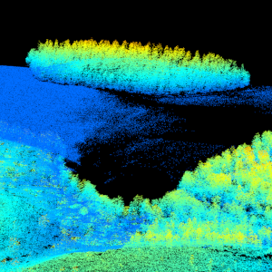
Laser scanning data refers to three-dimensional point-like data depicting the ground and objects on the ground. Each point is provided with x, y and z coordinate information. Laser scanning data is collected i.a. for updating elevation models, creating 3D geometries of buildings, mapping flood risks, and collecting information about forest resources. The terms of use must be approved to use laser scanning data.
-

Grid net for statistics 1 km x 1 km covers whole of Finland. The grid net includes all grid cells in Finland. The location reference of a grid cell is the coordinates of the bottom left corner of each grid cell. An identifier in accordance with national conventions (consecutive numbering) has also been produced for each grid cell. The Grid net for statistics 1 km x 1 km is the area division used in the production of statistics by 1 km x 1 km grid cells. For utilizing grid data auxiliary table of regional classifications are available: https://www.stat.fi/org/avoindata/paikkatietoaineistot/tilastoruudukko_1km_en.html. The general Terms of Use must be observed when using the data: https://tilastokeskus.fi/org/lainsaadanto/copyright_en.html. In addition to the national version, an INSPIRE information product is also available from the data.
-
Väestön terveys ja turvallisuus -tietotuottessa määritellään ympäristön laatuun välittömästi (esimerkiksi ilman pilaantuminen, kemikaalit, otsonikerroksen oheneminen, melu) tai välillisesti (esimerkiksi elintarvikkeet, muuntogeeniset organismit) yhteydessä olevien sairauksien (esimerkiksi allergiat, syövät, hengityselinsairaudet) maantieteellinen esiintyminen, tiedot, jotka osoittavat vaikutuksen terveyteen (esimerkiksi biologiset merkkiaineet, hedelmällisyyden väheneminen, epidemiat) tai ihmisten hyvinvointiin (esimerkiksi väsymys, stressi). Väestön terveys ja turvallisuus -tietotuotteiden aineistojen julkaisukanavana käytetään Terveyden ja hyvinvoinnin laitoksen tilasto- ja indikaattoripankki SOTKAnetiä. Palvelun kautta on saatavissa tietotuotteessa määritellyistä tiedoista - Sairaaloiden hoitojaksot ja -päivät sekä niiden keskimääräinen kesto - Polikliinisen hoidon potilaat - Terveysmenot - Koettu terveys - Painoindeksi - Tupakointi - Toimintakyky - Pitkäaikaissairaat erityiskorvattavien lääkkeiden oikeuksien perusteella - Kuolemansyyt ICD-10 -luokituksen pääryhmittäin Terveyden ja hyvinvoinnin laitoksen ylläpitämät kansalliset tilastot ja rekisterit väestön terveydestä ja hyvinvoinnista ovat pääasiallinen tietolähde. Syöpätietoja ylläpitää Terveyden ja hyvinvoinnin laitoksen puolesta Suomen Syöpäyhdistys. Tiedot osana tuottajien normaalia tilastotuotantoa ja sen tukitoimintaa.
-
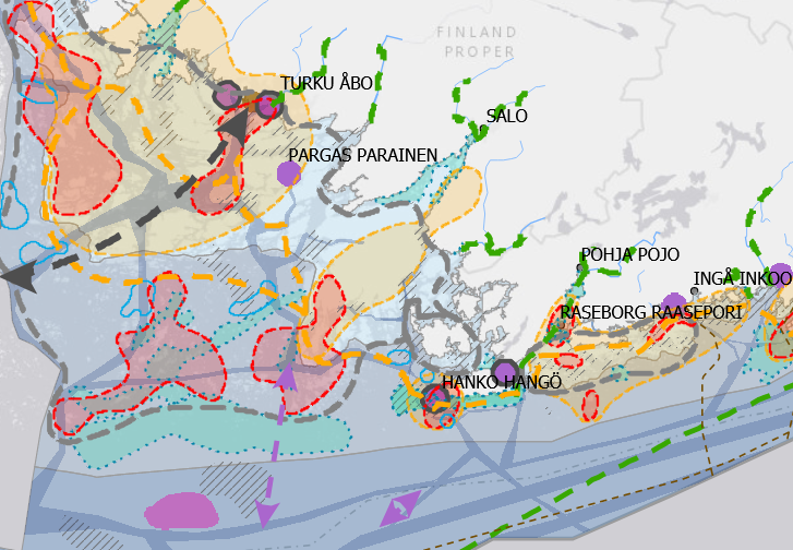
A maritime spatial plan is a strategic development document illustrated by a map. Map markings are used to show the values of marine areas and existing activities and potential future sites for new activities and their alternative placement in all of Finland’s marine areas. The plan covers the territorial waters and the Exclusive Economic Zone. The plan is not legally binding, but an assessment of its indirect and direct impacts and effectiveness forms part of the planning process. The administrative authorities of coastal regional councils approved the plan, prepared according to the Land Use and Building Act, between November and December 2020. The councils of coastal regions have prepared the maritime spatial plan in three different parts: Gulf of Finland (Helsinki-Uusimaa Regional Council and Regional Council of Kymenlaakso), Archipelago Sea and Southern Bothnian Sea (Regional Council of Southwest Finland and Regional Council of Satakunta), and Northern Bothnian Sea, Quark and Bothnian Bay (Regional Council of Ostrobothnia, Regional Council of Central Ostrobothnia, Council of Oulu Region and Regional Council of Lapland). The data is suitable for a general-level examination of Finnish marine areas. More information on maritime spatial plan: https://www.merialuesuunnitelma.fi.
-
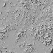
Hillshade (elevation model) is a raster dataset visualising the elevation of the terrain. There are five product versions available in which the pixel sizes are 2, 8, 32, 64, 128 and 512 metres. Pixel size 2 m has been produced of the dataset Elevation model 2 m. The other sizes have been produced of the dataset Elevation model 10 m. The material does not contain elevation values; it is a greyscale image that visualises the direction and steepness of hills. The product belongs to the open data of the National Land Survey of Finland.
-

Grid net for statistics 5 km x 5 km covers whole of Finland. The grid net includes all grid cells in Finland. The location reference of a grid cell is the coordinates of the bottom left corner of each grid cell. An identifier in accordance with national conventions (consecutive numbering) has also been produced for each grid cell. The Grid net for statistics 5 km x 5 km is the area division used in the production of statistics by 5 km x 5 km grid cells. For utilizing grid data auxiliary table of regional classifications are available: https://www.stat.fi/org/avoindata/paikkatietoaineistot/tilastoruudukko_5km_en.html. The general Terms of Use must be observed when using the data: https://tilastokeskus.fi/org/lainsaadanto/copyright_en.html. In addition to the national version, an INSPIRE information product is also available from the data.
-
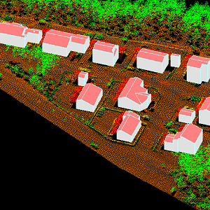
The 3D vectors for buildings are three-dimensional instances of the Building target category in the National Topographic Database (KMTK). The 3D vectors are produced with a high degree of automation from laser scanning data 5 p based on 2D vectors for buildings in KMTK. For the time being, data is available only from a few example areas, but the coverage will be extended to the whole of Finland as the laser scanning programme proceeds. The product belongs to the open data of the National Land Survey of Finland.
-
Laser scanning data refers to three-dimensional point-like data depicting the ground and objects on the ground. Each point is provided with x, y and z coordinate information. Laser scanning data is available from all of Finland. The product belongs to the open data of the National Land Survey of Finland. From 2020 onwards, laser scanning data according to the laser scanning programme will be produced. The product description of the 'Laser scanning data 5 p' according to the scanning programme is available: https://www.maanmittauslaitos.fi/en/maps-and-spatial-data/expert-users/product-descriptions/laser-scanning-data-5-p. A spaced-out open dataset will be created from the new Laser scanning data 5 p: https://www.maanmittauslaitos.fi/en/maps-and-spatial-data/expert-users/product-descriptions/laser-scanning-data-05-p. The characteristics of this dataset correspond to the Laser scanning data 2008–2019 dataset.
-
Laser scanning data refers to three-dimensional point-like data depicting the ground and objects on the ground. Each point is provided with x, y and z coordinate information. Laser scanning data 0.5 p has been spaced out from Laser scanning data 5 p's density of 5 p/m² to a density of 0.5 p/m². Laser scanning data 0.5 p is open data, and from 2020 onwards, it will be collected according to the national laser scanning programme (in Finnish): https://www.maanmittauslaitos.fi/laserkeilaus-ja-ilmakuvaus. For the time being, it is available only from certain parts of Finland. The product belongs to the open data of the National Land Survey of Finland. More information (in Finnish): https://www.maanmittauslaitos.fi/laserkeilausaineistot.
-
Elevation zones is a raster dataset that visualises elevation of the terrain. The product covers the whole of Finland. There are four product versions available in which the pixel sizes are 32, 64, 128 and 512 metres. The dataset does not contain elevation values; it is a colour image that visualises the height of the terrain above sea level as zones. The sea is shown in light blue in the elevation zone. The product Elevation zones is available as a version that covers the whole country and as versions that cover a certain area. The product belongs to the open data of the National Land Survey of Finland.