 Paikkatietohakemisto
annually
Type of resources
Topics
Keywords
Contact for the resource
Provided by
Years
Formats
Representation types
Update frequencies
Scale
-
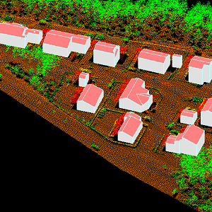
The 3D vectors for buildings are three-dimensional instances of the Building target category in the National Topographic Database (KMTK). The 3D vectors are produced with a high degree of automation from laser scanning data 5 p based on 2D vectors for buildings in KMTK. For the time being, data is available only from a few example areas, but the coverage will be extended to the whole of Finland as the laser scanning programme proceeds. The product belongs to the open data of the National Land Survey of Finland.
-
The data includes traffic volumes in Finland from 2012 to 2024. Data contains traffic volumes of all traffic and truck traffic.
-

Division into administrative areas (vector) is a dataset depicting the municipalities, regions, Economic development centres and the national border of Finland. The Division into administrative areas products in vector format contain the number codes of the municipalities, the names of the municipalities in both Finnish and Swedish as well as municipal boundaries and municipal geographical areas. In addition, the products include the corresponding information about the regions, the Economic development centres and the nation as well as a specification of the municipality's area into land and water area. The municipality's area is not included in the XML/GML and GeoPackage format. The dataset Municipal Division is produced in scales 1:10,000, 1:100,000, 1:250,000, 1:1,000,000 and 1:4,500,000. The data included in the dataset in scale 1:10,000 are taken from the Cadastre. Regarding other scales, municipal boundaries have been generalised to suit the scale in question. The product is a part of the open data of the National Land Survey.
-
National Land Survey's Topographic map in vector format is a dataset depicting the terrain of all of Finland. The most important elements are the road network, administrative borders, preservation areas, population centres, geographic names, waterways, land use and elevation. The largest scale level (1:100,000) of the Topographic map in vector format is produced by generalising from the Topographic database. Topographic map 1:250,000 is produced by generalising the dataset 1:100,000. Topographic map 1:1,000,000 is produced by generalising the dataset 1:250,000. Topographic map 1:4,500,000 is produced by generalising the dataset 1:1,000,000. The geographic names have been generalised from the geographic names in the Geographic Names Register to map names suited to the scale in question. The administrative borders in the Municipal Division of each scale are used as administrative borders. The product belongs to the open data of the National Land Survey of Finland.
-

Division into administrative areas (raster) is a dataset depicting the municipal Division of Finland. The dataset Municipal Division is produced in scales 1:10,000, 1:100,000, 1:250,000, 1:1,000,000 and 1:4,500,000. The data included in the dataset in scale 1:10,000 are taken from the Cadastre. Regarding other scales, municipal boundaries have been generalised to suit the scale in question. Division into administrative areas products in raster format include municipal boundaries only. The product is a part of the open data of the National Land Survey.
-
National Land Survey's geographic names are available as interfaces and files. Interfaces and file products comprise of place name products and map name products. The place name products include data about approximately 800,000 named places and their names in different languages. Data about place are among others place type, plane location and height above sea level, and data about names are among others the spelling that has been checked by the Institute for the Languages of Finland and language (Finnish, Swedish, Northern Sami, Inari Sami or Skolt Sami. In the place name products, every place and its name or names appear only once. The map name products contain the place names that have been selected for the National Land Survey's nine standard map products and information about the cartographical presentation of them. The information includes the location of the name on the map, for instance the coordinates of the left lower corner of the map text, the direction and bending of the text as well as typographical information, such as font type, size and colour. The name of a particular place, such as a river, can appear several times in the same map product. The product is a part of the open data of the National Land Survey.
-
Tasoristeysonnettomuudet-aineistossa esitetään tasoristeysten yhteydessä tapahtuneet onnettomuudet vuodesta 2000 vuoteen 2024. Aineistoa päivitetään kerran vuodessa. Aineistossa ei näy niiden tasoristeysten onnettomuuksia, jotka eivät ole enää käytössä. Lisäksi vuodesta 2021 alkaen aineistossa esitetään vain valtion tasoristeyksissä tapahtuneet onnettomuudet. Näin ollen yksityisradoilla tapahtuneita onnettomuuksia ei ole vuodesta 2021 alkaen enää mukana aineistossa. Edellä mainituista syistä onnettomuuksien vuosittaiset määrät saattavat erota siitä, mitä Väyläviraston verkkosivuille on kirjattu: https://vayla.fi/vaylista/aineistot/tilastot/ratatilastot/tasoristeysonnettomuudet
-
Kohteen alustavan stabiliteettilaskelman mukainen kokonaisvarmuus sortumista vastaan sallitulla akselipainolla alle 1,5. Aineisto päivittyy tarvittaessa.
-
Aineistossa on esitetty Suomen tieverkolla olevat nollapisteet ja nollapisteisiin mahdollisesti ohjaavat reitit. Aineistot on luotu Suomen Väylissä olevaa teemakarttaa "Eritasoliittymät ja nollapisteet" varten. Aineisto ei ole automaattisen päivityksen piirissä ja sitä päivitetään tarvittaessa.
-
Aineistoissa on esitetty Väyläviraston ratoja ja teitä koskevat korjausvelka-aineistot. Tietoihin sisältyvät seuraavat aineistot: - Maanteiden korjausvelka 2021 - Maanteiden korjausvelka 2022 - Maanteiden korjausvelka 2023 - Maanteiden korjausvelka 2024 - Maanteiden korjausvelka 2025 - Rataosuuksien korjausvelka 2021 - Rataosuuksien korjausvelka 2022 - Rataosuuksien korjausvelka 2023 - Rataosuuksien korjausvelka 2024 - Rataosuuksien korjausvelka 2025 Aineistojen joukkoon lisätään kerran vuodessa edellisen vuoden tiedot.