 Paikkatietohakemisto
continual
Type of resources
Topics
Keywords
Contact for the resource
Provided by
Years
Formats
Representation types
Update frequencies
status
Service types
Scale
-
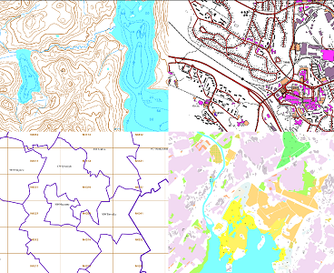
The themes of the Topographic database and Topographic map raster series (scale 1:10,000) have been compiled into seven theme entities, theme rasters, required by the Inspire directive: hydrography, elevation, traffic network, land use, land cover, place names and buildings. In addition to the above, the theme rasters also include the municipal division, road names and map sheet division as separate themes. The theme rasters have not been implemented according to the imaging technology defined in the Inspire directive. They will be produced later. The product belongs to the open data of the National Land Survey of Finland.
-

The Background map is a dataset product series in raster format that depicts the whole of Finland and that is meant for web use as a background material for thematic data. Its key objects are road names, roads and railways, buildings and constructions, administrative borders, geographical names, waterways, land use and addresses of buildings (from Ryhti/Finnish Environment Institute). The product belongs to the open data of the National Land Survey of Finland.
-
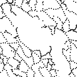
Control points and their coordinates and elevations define in practice the reference system for coordinates and elevations used in Finland. The NLS benchmark register contains information about nationwide control points and benchmarks. The marks are mainly horizontal and elevation control points in classes 1–3 measured by the National Land Survey of Finland. The product belongs to the open data of the National Land Survey of Finland.
-

The Topographic database is a dataset depicting the terrain of all of Finland. The key objects in the Topographic database are the road network, buildings and constructions, administrative borders, geographic names, land use, waterways and elevation. Aerial photographs, scanning data and data provided by other data providers are utilised in updating the Topographic database. The updating is done in close cooperation with the municipalities. Field checks in the terrain are also needed to some extent, mostly as regards the classification of features. The topographic database is used in the production of other map products and in various optimisation tasks. The product belongs to the open data of the National Land Survey of Finland.
-
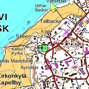
The Topographic map is a dataset depicting the terrain of all of Finland. The key elements in it are the road network, buildings and constructions, geographic names, waterways, land use and elevation. The more precise levels of the Topographic map consist of the same map objects and map symbols depicted in the same way as in the familiar Basic map. Basic map raster is applicable to be used, for instance, as a base map for planning land use or for excursion and outdoor recreational purposes in mobile devices and in various Internet services associated with nature. When going over to the more general datasets in the Topographic map, the number and visualisation of objects and map symbols changes. The generalised small-scale Topographic maps raster are applicable to be used as approach maps in e.g. mobile devices and Internet services. The product belongs to the open data of the National Land Survey of Finland.
-
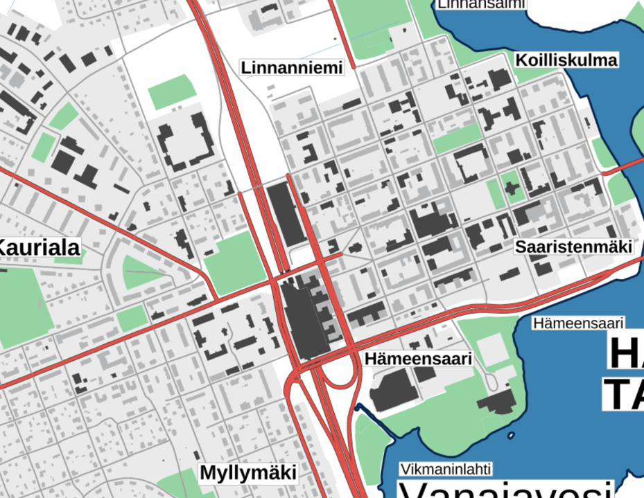
The Plain map series is a simple, plain and readable dataset product series in raster format that depicts the whole of Finland. The product is meant to be used as a background map whose character changes to a guide map in large scales. Impaired vision has been taken into account when designing the product. The key objects presented on the map are roads and railways, road names, buildings and constructions, administrative borders, waterways and other geographical names. The road network, public buildings and texts have been especially emphasised. The most usual limitations of colour vision have been taken into account in the use of colours. The product belongs to the open data of the National Land Survey of Finland.
-
KUVAUS: Tampereen kiinteistöt, määräalat, kaavayksiköt ja vuokratontit pisteinä ominaisuustietoineen. Aineisto ylläpidetään kuntarekisterissä. KATTAVUUS: Tampere PÄIVITYS: Jatkuvasti päivittyvä YLLÄPITOSOVELLUS: Facta KOORDINAATTIJÄRJESTELMÄ: Aineisto tallennetaan ETRS-GK24 (EPSG:3878) tasokoordinaattijärjestelmässä, saatavissa myös ETRS-TM35FIN (EPSG:3067) tasokoordinaattijärjestelmässä GEOMETRIA: pistemäinen SAATAVUUS: Aineisto on saatavilla WFS- ja WMS-rajapinnoilta, aineisto on tallennettu Oracle-tietokantaan. Aineisto on Oskari-karttapalvelussa julkaistu myös rasterimuodossa. JULKISUUS ja TIETOSUOJA: Julkinen KENTÄT: AINEISTO Onko kohde kiinteistö, määräala vai kaavayksikkö, ja kenties vuokratontti (vektorikarttatasossa näillä myös värikoodaus) KUNTA kolminumeroinen kuntanumero, Digi- ja väestötietoviraston ylläpitämä kooditus SIJAINTI kolminumeroinen sijaintialuenumero, joka voi olla kylän, asemakaava-alueella olevan kunnanosan, tai muun sellaisen alueen numero RYHMA nelinumeroinen ryhmäosa, joka tarkoittaa talon, asemakaava-alueella olevan korttelin, tai muun sellaisen alueen numeroa YKSIKKO nelinumeroinen yksikkönumero, joka tarkoittaa tilan numeroa, asemakaava-alueella olevan tontin numeroa, tai muuta vastaavaa numeroa C_TUNNUS_2 kiinteistötunnus, täydellisessä muodossa, muodostuu osista KUNTA-SIJAINTI-RYHMÄ-YKSIKKÖ C_TUNNUS kiinteistötunnus ilman etunollia Muut kuin kuntakoodi ovat kiinteistörekisterissä ylläpidettyjä. AINEISTOSTA VASTAAVA TAHO: Tampereen kaupunki, tekninen ylläpito Paikkatietoyksikkö, aineiston ylläpito Kiinteistönmuodostus
-
Tuusulan kunnan ulkoinen WFS-palvelu on WFS-rajapintapalvelu, jonka kautta on saatavilla samat aineistot kuin Tuusulan karttapalvelussa. Palvelu perustuu vastaaviin paikkatietoaineistoihin. Aineistoja hallinnoi Tuusulan kunnan paikkatieto. Palvelun käyttö on maksullista ja vaatii autentikoinnin eli tunnistautumisen käyttäjätunnuksen ja salasanan avulla. Käyttö vaatii sopimuksen tekemisen/käyttöluvan Tuusulan kunnalta.
-
Aineisto ei sovellu navigointikäyttöön. Vesiväylien turvalaitevioista julkaistaan kirjatut ja avoimet viat. Aineistossa näkyy turvalaitteen tiedot, vian tyyppi sekä kirjausaika. Aineisto päivittyy minuutin välein (päivitä näkymä, jotta saat uusimmat tiedot esille). Kauppamerenkulun väylien sekä matalaväylien turvalaiteviat on esitetty omilla tasoillaan.
-
KUVAUS: Tampereen määräalat pisteinä ominaisuustietoineen. Aineisto ylläpidetään kuntarekisterissä. KATTAVUUS: Tampere PÄIVITYS: Jatkuvasti päivittyvä YLLÄPITOSOVELLUS: Facta KOORDINAATTIJÄRJESTELMÄ: Aineisto tallennetaan ETRS-GK24 (EPSG:3878) tasokoordinaattijärjestelmässä, saatavissa myös ETRS-TM35FIN (EPSG:3067) tasokoordinaattijärjestelmässä GEOMETRIA: pistemäinen SAATAVUUS: Aineisto on tallennettu Oracle-tietokantaan. Aineisto on Oskari-karttapalvelussa julkaistu myös rasterimuodossa. JULKISUUS ja TIETOSUOJA: Julkinen KENTÄT: AINEISTO Onko kohde kiinteistö, määräala vai kaavayksikkö, ja kenties vuokratontti (vektorikarttatasossa näillä myös värikoodaus) KUNTA kolminumeroinen kuntanumero, Digi- ja väestötietoviraston ylläpitämä kooditus SIJAINTI kolminumeroinen sijaintialuenumero, joka voi olla kylän, asemakaava-alueella olevan kunnanosan, tai muun sellaisen alueen numero RYHMA nelinumeroinen ryhmäosa, joka tarkoittaa talon, asemakaava-alueella olevan korttelin, tai muun sellaisen alueen numeroa YKSIKKO nelinumeroinen yksikkönumero, joka tarkoittaa tilan numeroa, asemakaava-alueella olevan tontin numeroa, tai muuta vastaavaa numeroa C_TUNNUS_2 kiinteistötunnus, täydellisessä muodossa, muodostuu osista KUNTA-SIJAINTI-RYHMÄ-YKSIKKÖ C_TUNNUS kiinteistötunnus ilman etunollia Muut kuin kuntakoodi ovat kiinteistörekisterissä ylläpidettyjä. AINEISTOSTA VASTAAVA TAHO: Tampereen kaupunki, tekninen ylläpito Paikkatietoyksikkö, aineiston ylläpito Kiinteistönmuodostus