 Paikkatietohakemisto
2011
Type of resources
Available actions
Topics
Provided by
Years
Formats
Representation types
Update frequencies
Service types
Scale
Resolution
-

Luettelo ja kuvaus Kangasalan kunnan yleiskaavoista. Osaan kaavoista löytyy linkit kunnan www-sivulta.
-
Turun yliopiston merenkulkualan koulutus- ja tutkimuskeskuksen tuottama aineisto kattaa Turun ja Kotkan satamien merialueilla tehdyt vesistö-, kalasto- ja haitta-ainetutkimusraportit. Aineisto sisältää tutkimusraporttien tutkimusaluerajaukset. Aineistossa on yhdistetty Turun ja Kotkan merialueilla tehtyjen vesistö-, kalasto- ja haitta-ainetutkimuksien tutkimusalueet yhdeksi vektoriaineistoksi. Tutkimuksien PDF-dokumentit löytyvät NANNUT karttapalvelusta. Aineisto on katsottavissa Lounaistiedon karttapalvelusta https://karttapalvelu.lounaistieto.fi/
-
Turun yliopiston maantieteen ja geologian laitokselle laadittuun opinnäytetyöhön perustuva aineisto vapaa-ajan asumisen rakennustiheydestä Lounaistiedon toiminta-alueella.
-
Aineisto sisältää eduskuntavaalien tulokset Varsinais-Suomen vaalipiirissä vuonna 2011. Aineisto on tuotettu Varsinais-Suomen liitossa Tilastokeskuksen tietojen pohjalta.
-
Aineisto sisältää Lounaispaikan toiminta-alueella sijaitsevat tuulivoimalat.
-
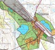
Nurmeksen yleiskaava-aineisto sisältää Höljäkän keskustan osayleiskaavan sekä Metsäkylä I:n osayleiskaavan ja edellisen osittaisen muutoksen (Sammaljärvi). Yleiskaavassa esitetään tavoitellun kehityksen periaatteet ja osoitetaan tarpeelliset alueet yksityiskohtaisen kaavoituksen ja muun suunnittelun sekä rakentamisen ja muun maankäytön perustaksi. Aineisto on tuotettu MapInfo/Tab - formaatissa. Kaavat ovat ladattavissa pdf-muodossa Lieksan ja Nurmeksen teknisen viraston verkkosivuilta. Nurmeksen kaupungin käyttämä aineistojen koordinaattijärjestelmä on EUREF-FIN (ETRS-GK29) ja korkeusjärjestelmä N2000. Aineistoa päivitetään mahdollisten kaavamuutosten mukaan.
-
The file presents ecological status of shallow inlets along the Swedish and Finnish Baltic Sea coast (excluding the Botninan Bay, the Quark and southern Scania County). The ecological status is based on submerged macrophytes and follows guidelines for biological quality elements in the European Union Water Framework Directive. The method was developed by Joakim Hansen (Stockholm University) during the project NANNUT (European Regional Development Fund, Central Baltic Interreg IVa, Archipelago and Islands). Macrophyte surveys were conducted in late July to early September 2001–2010 using the method of Persson & Johansson (2007). The classified inlets have been surveyed with a minimum of three line transects, which were located to represent most of the inlet area. A number of inlets have been surveyed during several years, other inlets just one year. The method for classification of ecological status is described in Hansen (2012), and full data is stored in the database 'GRUNDA' (2011).
-
Määrävuosin uusittava ortoilmakuvamosaiikki koko Keravan Kaupungin alueesta. Tällä hetkellä uusimmat kuvat ovat vuodelta 2009, maastoresoluutiolla 19cm. Kuvat ovat nähtävissä osoitteessa http://kartta.kuuma.fi/.
-
Turun yliopiston maantieteen ja geologian laitokselle laadittuun opinnäytetyöhön perustuva aineisto vapaa-ajan asumiseen rakennetusta rantaviivasta Lounaistiedon toiminta-alueella.
-
KUVAUS: Vesihuoltolain mukaiset vesihuoltolaitosten toiminta-alueet. KATTAVUUS: Tampere PÄIVITYS: Päivitetään yhdyskuntalautakunnan päätösten mukaan, käytännössä muutamien vuosien välein. YLLÄPITOSOVELLUS: Uusi aineisto toimitetaan paikkatietoyksikölle lautakunnan päätöksen jälkeen ja sillä korvataan vanha. KOORDINAATTIJÄRJESTELMÄ: Aineisto tallennetaan ETRS-GK24 (EPSG:3878) tasokoordinaattijärjestelmässä. GEOMETRIA: Aineisto on aluemaista SAATAVUUS: Aineisto on saatavilla WFS- ja WMS-rajapinnoilta, aineisto on tallennettu PostgreSQL/PostGIS-tietokantaan. JULKISUUS ja TIETOSUOJA: Aineisto on julkinen. KENTÄT: nimi Toiminta-alueen nimi tavoiteaik Tietokenttää ei ole käytetty huom Lisätietoa, esim. milloin toiminta-alueesta päätetty AINEISTOSTA VASTAAVA TAHO: Tampereen kaupunki, paikkatietoyksikkö sekä viheralueet ja hulevedet