 Paikkatietohakemisto
100000
Type of resources
Available actions
Topics
Keywords
Contact for the resource
Provided by
Years
Formats
Representation types
Update frequencies
status
Scale
-
The EMODnet (European Marine Observation and Data network) Geology project (http://www.emodnet-geology.eu/) collects and harmonizes marine geological data from the European sea areas to support decisionmaking and sustainable marine spatial planning. The partnership includes 39 marine organizations from 30 countries. The partners, mainly from the marine departments of the geological surveys of Europe (through the Association of European Geological Surveys- EuroGeoSurveys), have assembled marine geological information at a scale of 1:100 000 from all European sea areas (e.g. the White Sea, Baltic Sea, Barents Sea, the Iberian Coast, and the Mediterranean Sea within EU waters). This data includes the EMODnet seabed substrate map at a scale of 1:100 000 from the European marine areas. Traditionally, European countries have conducted their marine geological surveys according to their own national standards and classified substrates on the grounds of their national classification schemes. These national classifications are harmonized into a shared EMODnet schema using Folk's sediment triangle with a hierarchy of 16, 7 and 5 substrate classes. The data describes the seabed substrate from the uppermost 30 cm of the sediment column. The data has been generalized into a target scale (1:100 000). The smallest cartographic unit within the data is 0.05 km2 (5 hectares). Further information about the EMODnet-Geology project is available on the portal (http://www.emodnet-geology.eu/).
-

Division into administrative areas (raster) is a dataset depicting the municipal Division of Finland. The dataset Municipal Division is produced in scales 1:10,000, 1:100,000, 1:250,000, 1:1,000,000 and 1:4,500,000. The data included in the dataset in scale 1:10,000 are taken from the Cadastre. Regarding other scales, municipal boundaries have been generalised to suit the scale in question. Division into administrative areas products in raster format include municipal boundaries only. The product is a part of the open data of the National Land Survey.
-

The map sheet division is a system created for printing maps, which covers map sheet codes, map scales and map sheet sizes. Today, map sheet division is also used for other purposes. It is also possible to download other NLS datasets in addition to maps in accordance with map sheet division. The map sheet division TM35, which is based on the projected coordinate reference system ETRS-TM35FIN is in use today. Before 2007, a map sheet division that was based on the KKS coordinate reference system was used. The TM35 map sheet division consists of 7 different grid sizes, the smallest scale is 1:200,000 and the largest is 1:5000. An explanation of how the grids are further split into more detailed grids and the principles of map sheet numbering is on the National Land Survey website (in Finnish) https://www.maanmittauslaitos.fi/kartat-ja-paikkatieto/kartat/osta-kartta/nain-loydat-oikean-karttalehden. The attribute data of the grids include map sheet number, the area of a square on the grid, perimeter and the coordinates of the centre of the square. The map sheet division is available as a file in vector format and through our contract-based WMTS service in raster format. In addition, you can view it in the geoportal Paikkatietoikkuna. The product is a part of the open data of the National Land Survey.
-
National Land Survey's Topographic map in vector format is a dataset depicting the terrain of all of Finland. The most important elements are the road network, administrative borders, preservation areas, population centres, geographic names, waterways, land use and elevation. The largest scale level (1:100,000) of the Topographic map in vector format is produced by generalising from the Topographic database. Topographic map 1:250,000 is produced by generalising the dataset 1:100,000. Topographic map 1:1,000,000 is produced by generalising the dataset 1:250,000. Topographic map 1:4,500,000 is produced by generalising the dataset 1:1,000,000. The geographic names have been generalised from the geographic names in the Geographic Names Register to map names suited to the scale in question. The administrative borders in the Municipal Division of each scale are used as administrative borders. The product belongs to the open data of the National Land Survey of Finland.
-
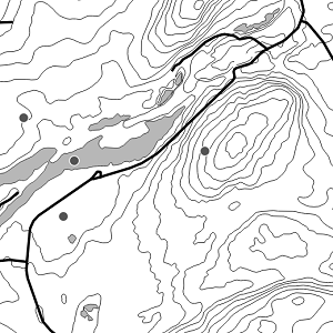
Seabed substrate 1:100 000 is one of the products produced in the EMODnet (European Marine Observation and Data network) Geology III EU project. Project provided seabed geological material from the European maritime areas. The EMODnet Geology III project (http://www.emodnet-geology.eu/) collects and harmonizes geological data from the European sea areas to support decision-making and sustainable marine spatial planning. The EMODnet Geology partnership has included 39 marine organizations from 30 countries. This data includes the EMODnet seabed substrate map at a scale of 1:100 000 from the Finnish marine areas. It is based on the data produced on a scale of 1:20 000 by the Geological Survey of Finland (GTK). The data has been harmonized and reclassified into five Folk substrate classes (clay + silt (mud), sandy clays, clayey sands, coarse sediments, mixed sediments) and bedrock. The data describes the seabed substrate from the uppermost 30 cm of the sediment column. The data have been generalized into a target scale (1:100 000). The smallest smallest cartographic unit within the data is 0.05 km2 (5 hectares). Further information about the EMODnet-Geology project III is available on the portal (http://www.emodnet-geology.eu/). Permission (AN17367) to publish the material was obtained from the Finnish Defence Office 29.9.2017.
-

Division into administrative areas (vector) is a dataset depicting the municipalities, regions, Economic development centres and the national border of Finland. The Division into administrative areas products in vector format contain the number codes of the municipalities, the names of the municipalities in both Finnish and Swedish as well as municipal boundaries and municipal geographical areas. In addition, the products include the corresponding information about the regions, the Economic development centres and the nation as well as a specification of the municipality's area into land and water area. The municipality's area is not included in the XML/GML and GeoPackage format. The dataset Municipal Division is produced in scales 1:10,000, 1:100,000, 1:250,000, 1:1,000,000 and 1:4,500,000. The data included in the dataset in scale 1:10,000 are taken from the Cadastre. Regarding other scales, municipal boundaries have been generalised to suit the scale in question. The product is a part of the open data of the National Land Survey.
-
The 1:100 000 scale bedrock map data of the Geological Survey of Finland (GTK) include material produced during 1948-2007 for the needs of the mapping of mineral resources, for the sustainable exploitation of aggregate resources and for scientific research. These data include lithological information as polygons, bedrock observation points and drilling sites as well as essential tectonic observations, and information on lithological primary structures, ore minerals and metamorphic index minerals. Some 1:100 000 map sheets give both stratigraphical information as well as lithological data. An explanatory text accompanies most map sheets.
-
Paavo - Open data by postal code area contain the following geographic data: 1) Paavo postal code areas 2) Paavo postal code areas (extended to sea areas) 3) Paavo statistical data (104 variables) combined with the postal code areas There are two different versions of the map data: extending to sea areas (2) mainly produced for statistics production, and the version produced from this for map visualisation cut with the coastline (1). The map data contain the surface areas of the postal code areas and the municipality codes defined for the postal code areas. Paavo statistical data (3) contain data on the population structure, the degree of education, the income of the inhabitants and households, the size of house-holds and life stage, buildings and dwellings, workplaces, and the main ac-tivities of the inhabitants. New data are updated annually in January. The data descriptions can be found in this link: https://stat.fi/en/services/statistical-data-services/statistical-databases/paavo The statistical data are also available in the PxWeb database: https://pxdata.stat.fi/PxWeb/pxweb/en/Postinumeroalueittainen_avoin_tieto/ The data are protected. Protected data are indicated with -1. The general Terms of Use must be observed when using the data: https://stat.fi/en/about-us/get-to-know-statistics-finland/legislation/terms-of-use
-
The Topographic map is a dataset depicting the terrain of all of Finland. The key elements in it are the road network, buildings and constructions, geographic names, waterways, land use and elevation. The more precise levels of the Topographic map consist of the same map objects and map symbols depicted in the same way as in the familiar Basic map. Basic map raster is applicable to be used, for instance, as a base map for planning land use or for excursion and outdoor recreational purposes in mobile devices and in various Internet services associated with nature. When going over to the more general datasets in the Topographic map, the number and visualisation of objects and map symbols changes. The generalised small-scale Topographic maps raster are applicable to be used as approach maps in e.g. mobile devices and Internet services. The product belongs to the open data of the National Land Survey of Finland.
-

Österbottens landskapsplan 2050 godkändes på landskapsfullmäktiges möte 7.4.2025 och trädde ikraft 2.7.2025 i enlighet med 201 § i lagen om områdesanvändning. Härmed upphävde Österbottens landskapsplan 2050 Österbottens landskapsplan 2040. Österbottens landskapsplan 2050 är en strategisk plan, där nationella målsättningar kombineras med landskapets egna målsättningar. Planen är en helhetslandskapsplan som omfattar hela landskapet Österbotten och behandlar alla de delområden i samhället som har en betydande inverkan på samhällsstrukturen och områdesanvändningen. Landskapsplanens mål är att Österbotten år 2050 ska vara en ledande region för hållbar utveckling, med bra livsmiljö, invånarna i centrum och ett blomstrande näringsliv. Målet med landskapsplanen är att Österbotten år 2050 ska vara ett föregångsområde för hållbar utveckling, med en god livsmiljö, där invånarna står i centrum och näringslivet blomstrar. Mer information om landskapsplanen finns på: https://www.obotnia.fi/sv/aluesuunnittelu/pohjanmaan-maakuntakaava-2050 Landskapsplanens material finns tillgängligt i vektorformat som ESRI File Geodatabase-material och via WFS-gränssnittstjänster samt i rasterformat via WMS-gränssnittet. Geodatamaterialet innehåller planområdets avgränsning, planobjekt och kodförteckningar. Planobjekten är indelade i kartlager för områdesreserveringar, delområden, punkter och linjer. Materialets attributdata innehåller bl.a. objektets namn, planbeteckningens namn och dess bokstavsförkortning. Via WMS-gränssnittet är landskapsplanens material tillgängligt med två olika visualiseringar: landskapets officiella visualisering och en enhetlig visualisering (HAME-datamodellen). HAME-visualiseringen baseras på de planbeteckningar som utvecklats och gemensamt överenskommits inom HAME-projektet (Harmoniserade landskapsplaner som e-tjänster). Mer information om HAME-projektet: http://www.syke.fi/hankkeet/hame