 Paikkatietohakemisto
2022
Type of resources
Available actions
Topics
Keywords
Contact for the resource
Provided by
Years
Formats
Representation types
status
Service types
Scale
Resolution
-
This dataset contains the ship accidents in the Baltic Sea during the period 1989 to end of 2023. It is constructed from the annual data collected by HELCOM Contracting Parties on ship accidents in the Baltic Sea and starting from 2019 from EMSA EMCIP Database extraction (for those Contracting Parties that are member of the EU). The accident data has been compiled by the HELCOM Secretariat and EMSA. According to the decision of the HELCOM SEA 2/2001 shipping accident data compilation will include only so-called conventional ships according to the Regulation 5, Annex I of MARPOL 73/78 - any oil tanker of 150 GT and above and any other ships of 400 GT and above which are engaged in voyages to ports or offshore terminals under the jurisdiction of other Parties to the Convention. According to the agreed procedure all accidents (including but not limited to grounding, collision with other vessel or contact with fixed structures (offshore installations, wrecks, etc.), disabled vessel (e.g. machinery and/or structure failure), fire, explosions, etc.), which took place in territorial seas or EEZ of the Contracting Party irrespectively if there was pollution or not, are reported. The dataset contains the following information: Unique_ID = An unique identifier consisting of 4 digit running number and the year of the accident Country Year Date = Date (dd/mm/yyyy) Time = Time of the accident (hh:mm) Location = Location of the accident (open sea / port / port approach, from 2019 -> open sea / port) Acc_Type = Type of accident Colli_Type = Type of collision / contact (with vessel / object) Acc_Detail = More information on the accident CauseDetai = Details on the accident cause Assistance = Assistance after the accident Offence = Offence against Rule Damage = Damage to the ship HumanEleme = Occurrence / Reason of human error IceCondit = Ice conditions CrewIceTra = Crew trained for ice conditions Pollution = Pollution (Yes/No) Pollu_m3 = Pollution in m3 Pollu_t = Pollution in tonnes Pollu_Type = Type of pollution RespAction = Response actions after the accident Cargo_Type = Type of cargo Ship1_Name = Ship 1 identification (Not published after 2018) Sh1_Categ = Ship 1 type (according to AIS category) Sh1_Type = Ship 1 more detail ship type category Sh1_Hull = Ship 1 hull construction Sh1Size_gt = Ship 1 GT Sh1Sizedwt = Ship 1 DWT Sh1Draug_m = Ship 1 draught in meters / category Cause_Sh1 = Cause of accidents from ship 1 Pilot_Sh1 = Presence of pilot on ship 1 Ship2_Name = Ship 2 identification (Not published after 2018) Sh2_Categ = Ship 2 type (according to AIS category) Sh2_Type = Ship 2 more detail ship type category Sh2_Hull = Ship 2 hull construction Sh2Size_gt = Ship 2 GT Sh2Sizedwt = Ship 2 DWT Sh2Draug_m = Ship 2 draught in meters / category Cause_Sh2 = Cause of accidents from ship 2 Pilot_Sh2 = Presence of pilot on ship 2 Add_Info = Additional information Latitude = Latitude (decimal degrees) Longitude = Longitude (decimal degrees) For more information about shipping accidents in the Baltic Sea, see the HELCOM annual reports: https://helcom.fi/helcom-at-work/publications/ https://helcom.fi/media/publications/HELCOM-report-on-Shipping-accidents-in-the-Baltic-Sea-2019-211207-FINAL.pdf
-
The data compiles seabed remote sensing situation since the 1960s. The data includes spatial data and metadata related to each survey line, mainly based on the data produced by the Geological Survey of Finland
-
This dataset contains borders of the HELCOM MPAs (former Baltic Sea Protected Areas (BSPAs). The dataset has been compiled from data submitted by HELCOM Contracting Parties. It includes the borders of designated HELCOM MPAs stored in the http://mpas.helcom.fi. The designation is based on the HELCOM Recommendation 15/5 (1994). The dataset displays all designated or managed MPAs as officially reported to HELCOM by the respective Contracting Party. The latest related HELCOM publication based on MPA related data is http://www.helcom.fi/Lists/Publications/BSEP148.pdf The dataset contains the following information: MPA_ID: Unique ID of the MPA as used in HELCOM Marine Protected Areas database Name: Name of the MPA Country: Country where MPA is located Site_link: Direct link to site's fact sheet in the http://mpas.helcom.fi where additional information is available MPA_status: Management status of the MPA Date_est: Establishment date of the MPA Year_est: Establishment year of the MPA
-
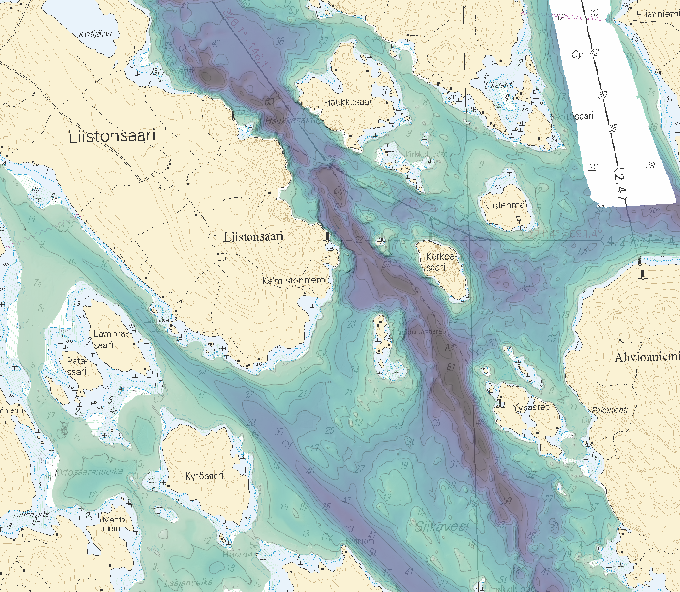
Ei toistaiseksi saatavilla. Liikenne- ja viestintävirasto Traficomin syvyysmittausaineistojen latauspalvelu on WCS-standardin mukainen latauspalvelu, jonka kautta on mahdollista ladata rasterimuodossa (GeoTIFF) julkisia syvyysmittausaineistoja sisävesiltä ja aineiston täydentyessä myös merialueelta talousvyöhykkeeltä. Palvelu on tarkoitettu WCS (Web Coverage Service) -standardia tukevien sovellusten käyttöön. Rasteriaineistot tarjotaan ETRS-TM35FIN (EPSG:3067) -projektiossa tiilitettyinä 10 x 10 km:n ruutuihin keskiarvopintamallina 2 x 2 m:n spatiaalisessa resoluutiossa. Palvelu perustuu Traficomin syvyysmittausaineistoon. Palvelussa oleva aineisto päivittyy syvyyspisterekisterin täydentyessä. Palvelun kautta saatavilla olevia aineistoja ei ole tarkoitettu navigointikäyttöön, eivätkä ne täytä asianmukaiselle merikartalle asetettuja vaatimuksia.
-
KUVAUS: Yleisellä alueella oleva lumesta muotoiltu ja jäädytetty mäki. Talviliukumäet toteutetaan vuosittain lumitilanteen mukaan. KATTAVUUS: Tampere PÄIVITYS: Aineiston ylläpito jatkuvaa YLLÄPITOSOVELLUS: Trimble Locus KOORDINAATTIJÄRJESTELMÄ: Aineisto tallennetaan ETRS-GK24 (EPSG:3878) tasokoordinaattijärjestelmässä. GEOMETRIA: Aineisto on pistemäistä. SAATAVUUS: Aineisto on saatavilla WFS- ja WMS-rajapinnoilta sekä kaupungin datapalvelusta, ja katsottavissa Oskari-karttapalvelussa sekä kansallisessa Paikkatietoikkunassa, aineisto on tallennettu SQL-tietokantaan. JULKISUUS JATIETOSUOJA: Aineisto on julkinen. KENTÄT: • Viheralueen nimi ja tunnus: Viheralueen virallinen nimi (kaavassa tai yhdyskuntalautakunnan päätös) tai virallisluontoinen nimi (liikunta-alueilla liikunta-alueen nimi) sekä karttalehtinumero ja järjestysnumero esim. 1989-013 • Viheralueen käyttöluokka: Esim. yleiset viheralueet, suojaviheralueet • Kunnossapitäjä: Alueen kunnossapitäjä • Alueurakka-alue: Kunnossapidon urakka-alue, jonka alueella talviliukumäki on AINEISTOSTA VASTAAVA TAHO: Tampereen kaupunki, viheralueet ja hulevedet -yksikkö
-
Kymenlaakson maakuntakaava (HAME) WMS-rajapintapalvelun kautta ovat saatavilla seuraavat karttatasot (suluissa tekninen nimi): Palvelun lähtöaineistoina on käytetty mm. Maanmittauslaitoksen Maastotietokantaa ja SYKE:n aineistoja. Aineistoja hallinnoi Kymenlaakson maakunta, palvelusta vastaa Lounaistieto. Palvelun käyttö on maksutonta eikä vaadi autentikointia eli tunnistautumista käyttäjätunnuksen ja salasanan avulla.
-
KUVAUS: Asemakaavoitetujen kaupungin omistamien puistojen ja suojaviheralueiden kunnossapitoluokitus. Viheralueet on jaettu erilaisiin kunnossapitoluokkiin alueen käyttötarkoituksen ja käyttäjien, luonnonolojen sekä viheralueen laatu- ja kustannustavoitteiden mukaan. Kunnossapitoluokitus ohjaa toiminnallisesti monipuolisen ja luonnonoloiltaan monimuotoisen viherverkon ylläpitoa. Samalla se tukee tasapainoisen ja kestävän kaupunkirakenteen tavoitetta. Kaupungin omistamat viheralueet on jaettu erilaisiin kunnossapitoluokkiin alueen käyttötarkoituksen ja käyttäjien, luonnonolojen sekä viheralueen laatu- ja kustannustavoitteiden mukaan. Kunnossapitoluokitus ohjaa toiminnallisesti monipuolisen ja luonnonoloiltaan monimuotoisen viherverkon ylläpitoa. Samalla se tukee tasapainoisen ja kestävän kaupunkirakenteen tavoitetta. Viheralueiden hoitoluokitus ja hoitotavoitteet perustuvat julkaisuun Viheralueiden hoitoluokitus 2007, Viherympäristöliitto ry:n julkaisu 36 Helsinki. Viheralueiden kunnossapitoluokitus RAMS 2020, Viherympäristöliitto ry:n julkaisu 67 (luokat päivitetään ja hoitoluokituksesta siirrytään kunnossapitoluokitukseet v. 2021 aikana) Lisätietoa: Viheralueiden kunnossapitoluokitus RAMS: https://www.vyl.fi/ohjeet/kunnossapitoluokitus/ KATTAVUUS: Tampere PÄIVITYS: Aineiston ylläpito jatkuvaa YLLÄPITOSOVELLUS: Trimble Locus KOORDINAATTIJÄRJESTELMÄ: Aineisto tallennetaan ETRS-GK24 (EPSG:3878) tasokoordinaattijärjestelmässä. GEOMETRIA: Aineisto on aluemaista. SAATAVUUS: Aineisto on saatavilla WFS- ja WMS-rajapinnoilta sekä kaupungin datapalvelusta, ja katsottavissa Oskari-karttapalvelussa sekä kansallisessa Paikkatietoikkunassa, aineisto on tallennettu SQL-tietokantaan. JULKISUUS JATIETOSUOJA: Aineisto on julkinen. KENTÄT: • Viheralueen nimi ja tunnus: Viheralueen virallinen nimi (kaavassa tai yhdyskuntalautakunnan päätös) tai virallisluontoinen nimi sekä karttalehtinumero ja järjestysnumero esim. 1989-013 • Viheralueosalaji: Kuvaa alueen käyttöä/tyyppiä esim. nurmi, perenna, leikkialue, pensas, kenttä, kuntoilualue • Viheralueen käyttöluokka: Esim. yleiset viheralueet, suojaviheralueet • Kunnossapitoluokka: alueen hoito tai kunnossapitoluokka, esim. R1, R2, R3, A1, A2 • Kunnossapitoluokka selite: Kunnossapitoluokan tarkempi selite esim. R1 Rakennettu arvoviheralue • Tilaaja: Alueen kunnossapidon tilaaja • Kunnossapitäjä: Alueen kunnossapitäjä • Pinta-ala m2: Pinta-ala neliömetreinä • Alueurakka-alue: Kunnossapidon urakka-alue, johon viheralue kuuluu AINEISTOSTA VASTAAVA TAHO: Tampereen kaupunki, viheralueet ja hulevedet -yksikkö
-
KUVAUS Tampereen lahokaviosammalselvitys on laadittu Tampereen kaupungin tilauksesta vuonna 2021. Selvityksen tavoitteena oli lahokaviosammalen yleisyyden ja suotuisan suojelutason arviointi Tampereella. Selvitys perustuu kantakaupungin yleiskaavan viherverkon alueella ja tietyillä Pohjois-Tampereen kohteilla tehtyihin, laajoihin maastokartoituksiin. Mahdollisesti kartoitettavat, lahokaviosammalelle soveltuvat alueet määriteltiin paikkatietomenetelmillä työn esiselvitysvaiheessa. Lajin asema erittäin uhanalaisena (EN), rauhoitettuna ja luontodirektiivin liitteen II(b) lajina velvoittaa huomioimaan lajin kasvupaikat muun muassa maankäytön suunnittelussa siten, että lajin suojelutaso ei vaarannu. KARTOITUSALUEET: Ne soveltuvat alueet, jotka sijoittuvat kantakaupungin yleiskaavan viherverkon alueelle. OSA-ALUERAJAT: Maastotöiden kohdentamista varten tehty osa-aluejako. SOVELTUVAT ALUEET: Esiselvityksessä tunnistettu lahokaviosammalelle mahdollisesti soveltuva alue. ERITYISEN SOVELTUVAT ALUEET: Esiselvityksessä tunnistettu lahokaviosammalelle mahdollisesti erittäin soveltuva alue. LOPULLISET HAVAINNOT: Maastotöiden aikana tehdyt havainnot. Aineistosta on erillinen kuvaus. YDINALUEET: Lajille tärkeät ydinalueet on tunnistettu ja rajattu kartoille jo maastotöiden yhteydessä lahokaviosammalen itujyväsryhmien ja itiöpesäkkeiden esiintyvyyden ja kasvupaikkojen ominaisuuksien perusteella. Lopulliset rajaukset on tehty myöhemmin paikkatieto-ohjelmalla havaintojen, itujyväsryhmien elinvoimaisuuden (runsausluokat 1-3) ja esiintymisalueen ominaispiirteiden (muun muassa kosteusolosuhteet, puuston rakenne ja lahopuujatkumo sekä maastonmuodot) perusteella. KATTAVUUS; PÄIVITYS; LUOTETTAVUUS Kattaa Tampereen lahokaviosammalselvityksen 2021 kartoitusalueiden havainnot. YLLÄPITOSOVELLUS; KOORDINAATISTOJÄRJESTELMÄ; GEOMETRIA; SAATAVUUS; JULKISUUS Aineisto tallennetaan ETRS-GK24 (EPSG:3878) tasokoordinaattijärjestelmässä. Aineisto on saatavilla WFS- ja WMS2-rajapinnoilta, aineisto on tallennettu PostgreSQL-tietokantaan. Aineisto tarkoitettu kaupungin sisäiseen käyttöön. YHTEYSHLÖ Ympäristönsuojeluyksikkö (ymparistonsuojelu@tampere.fi) ja yleiskaavoitus. POIKKILEIKKAUS Tallennettu vuoden 2021 aikana. KENTÄT NIMI (nimi) Ydinalueen nimi NUMERO (nro) Ydinalueen tunnunumero OSA_ALUE_NUMERO (osa_a_nro) Ydinalueen osa-aluenumero. Erotetaan pilkulla esim. 1,1. Sarake jätetään tyhjäksi, jos ei osa-aluetta. PINTA_ALA_HEHTAAREINA (p_ala_ha) Ydinalueen pinta-ala KASVUPAIKKATYYPPI (kp_tyyppi) Ydinalueen kasvupaikan tyyppi. Käytetään seuraavia vaihtoehtoja: karukko kuiva kuivahko tuore lehtomainen lehto Jos useita kasvupaikkatyyppejä, kirjataan kaikki esim: tuore, lehtomainen, lehto LAHOPUUMAARA (lahop_m3) Ydinalueen lahopuumäärä. Vaihtoehdot: 1 = <5m3 /ha 2 = 5-20m3 /ha 3 = >20m3 /ha PINTA_ALA_PISTEET (p_ala_p) Pinta-ala hehtaareissa (ha) mukaiset pisteet 1 piste: < 6ha 2 pistettä: 6-12 ha 3 pistettä: > 12 ha KASVUPAIKKOJEN_MAARA (ip_kp_p) Itiöpesäkkeiden kasvupaikkojen (esim. lahopuurunko / kanto) lukumäärän mukaiset pisteet 1 piste: 2 kasvupaikkaa 2 pistettä: 3-4 kasvupaikkaa 3 pistettä: > 4 kasvupaikkaa ITIOPESAKKEIDEN_MAARA (ip_lkm_p) Itiöpesäkkeiden kokonaislukumäärä ydinalueella -pisteet 1 piste: 1-10 itiöpesäkettä 2 pistettä: 11-30 itiöpesäkettä 3 pistettä: > 30 itiöpesäkettä ITUJYVASRYHMIEN_KASVUPAIKKOJEN_MAARA (ijr_kp_p) Itujyväsryhmien kasvupaikkojen kokonaislukumäärä ydinalueella -pisteet 0 pistettä: 0-5 kasvupaikkaa 1 piste: 6-49 kasvupaikkaa 2 pistettä: > 49 kasvupaikkaa YDINALUEET_LAHELLA (lah_ydin_p) Alle 1km:n päässä olevat lahokaviosammalen ydinalueet -pisteet 1 piste: 1 ydinalue 2 pistettä: 2 ydinaluetta 3 pistettä: > 2 ydinaluetta LUONNONSUOJELUALUEET_LAHELLA (lah_sl_p) Alle 500 metrin päässä olevat luonnonsuojelualueet -pisteet 1 piste: 1 luonnonsuojelualue 2 pistettä: 2 luonnonsuojelualuetta 3 pistettä: > 2 luonnonsuojelualuetta ELINYMPARISTON_RAKENNEPIIRTEET (elinymp_p) Elinympäristön rakennepiirteet -pisteet: lahopuusto ja metsärakenne 0 pistettä: Kohteen lahopuuston laatu tulee heikkenemään jatkossa merkittävästi. Käytännössä kohde, jossa kasvupaikat ovat vanhoilla kannoilla eikä uutta lahopuuta ole muodostumassa lähivuosikymmeninä. 1 pistettä: Metsänrakenne ja lahopuujatkumo kohtalaisen hyviä lajille. On odotettavissa, että lahopuustoa syntyy merkittävästi lisää, jos kohteen annetaan kehittyä rauhassa. 2 pistettä: Lahopuun määrä ja jatkumo on erinomainen ja tilanne pysyy samana tai paranee jatkossa. Usein kyseessä on suojelualue tai muu erityisen laadukas ja vakaa kohde. KARTOITUKSET_TARKKUUS (tark_p) 0 pistettä: Kohde on hyvin tutkittu. Suurin osa kaikista potentiaalisista kasvupaikoista (kasvupaikka=erillinen lahopuuyksikkö kuten maapuurunko, runko tai muu lahopuukappale) on tutkittu sekä itiöpesäkkeiden että itujyväsryhmien osalta. 1 piste: Tarkasti tutkittu kohde sekä itujyväsryhmien että itiöpesäkkeiden osalta, mutta silti arviolta alle puolet kaikista potentiaalisista kasvupaikoista tutkittu. 2 pistettä: Hyvin tarkka itiöpesäkkeiden etsintä tai osittainen itujyväsryhmät huomioiva kartoitus. Alle 10% potentiaalisista kasvupaikoista tutkittu. 3 pistettä: Melko tarkka itiöpesäkkeiden etsintä tai yleispiirteinen nopea kartoitus, jossa sekä itiöpesäkkeitä että itujyväsryhmiä etsittiin. 4 pistettä: Suurpiirteinen itiöpesäkkeiden / itujyväsryhmä -runkojen etsintä laajalla alueella tai vain yksittäishavainto pienehköllä kohteella. MAASTON_KULUMINEN (kulum_p) Maaston kuluminen virkistyskäytön takia 0 pistettä: Maaston kuluminen ja lahopuiden vaurioituminen ei ole kohteella ongelma tai se koskee vain yksittäisiä runkoja laajalla alueella. 1 piste: Lievää kulumista koko alueella tai raskasta kulumista pienellä osalla aluetta. 2 pistettä: Virkistyskäyttö vaikuttaa oleellisesti kohteen laatuun ja lahopuustoon. Mekaaniset vauriot potentiaalisille tai tunnistetuille kasvupaikoille ovat merkittävä uhka esiintymälle tällä hetkellä tai tulevaisuudessa. KOKONAISPISTEMAARA (kok_p) Ydinalueen pisteytyksen kriteerikohtaisten pisteiden summa. Kokonaispistemäärään ei lasketa lahopuumäärä (lahop_m3) - sarakkeen pisteitä. LISAYS_PVM (lisays_pvm) Ydinalueen lisäyspäivämäärä. TIETOLAHDE (tietolahde) Selvityksen Donna-ID-numero tai muu viite raporttiin tai muuhun tietolähteeseen.
-
Juna- ja metroasemien ajallinen saavutettavuus kävellen sekä pyöräillen kevyenliikenteen reittejä pitkin. Saavutettavuusvyöhykkeet on laskettu 5, 10 ja 15 min aikajänteelle. Laskenta on aloitettu asemien/laiturialueiden sisäänkäyntipisteistä. Kävelynopeudeksi on määritelty 5,2 km/h ja pyöräilynopeudeksi 14 km/h. Mukana on kaikki Helsingin seudun ja Siuntion juna- sekä metroasemat, joita on yhteensä 83 kpl. Aineisto on Esrin shapefile-muodossa ja koordinaatisto on ETRS-GK25 (EPSG:3879). Aineistoa on päivitetty vuonna 2022. Aineisto ensimmäisen kerran 2016, jolloin toteutus pohjautui Elinvoimaiset Asemanseudut Helsingin seudulla ja Uudellamaalla – projektin (ELIAS) työpaketti 2:n lopputuotteeseen. ELIAS oli HSY:n, Uudenmaan liiton sekä Ympäristöministeriön kanssa yhteistyössä toteutettava projekti, minkä tavoitteina oli asemanseutuja koskevan tietopohjan parantaminen, asemanseutujen potentiaalin tehokkaampi hyödyntäminen sekä niiden toimivuuden ja houkuttelevuuden kehittäminen osana uudentyyppistä kaupunkikehitystä ja vähähiilistä yhteiskuntaa. ELIAS-projektin työpaketti 2 toteutettiin vuoden 2015 aikana. Aineisto löytyy osoitteesta: hsy.fi/avoindata sekä http://kartta.hsy.fi/. Lisätietoja antaa avoindata@hsy.fi.
-
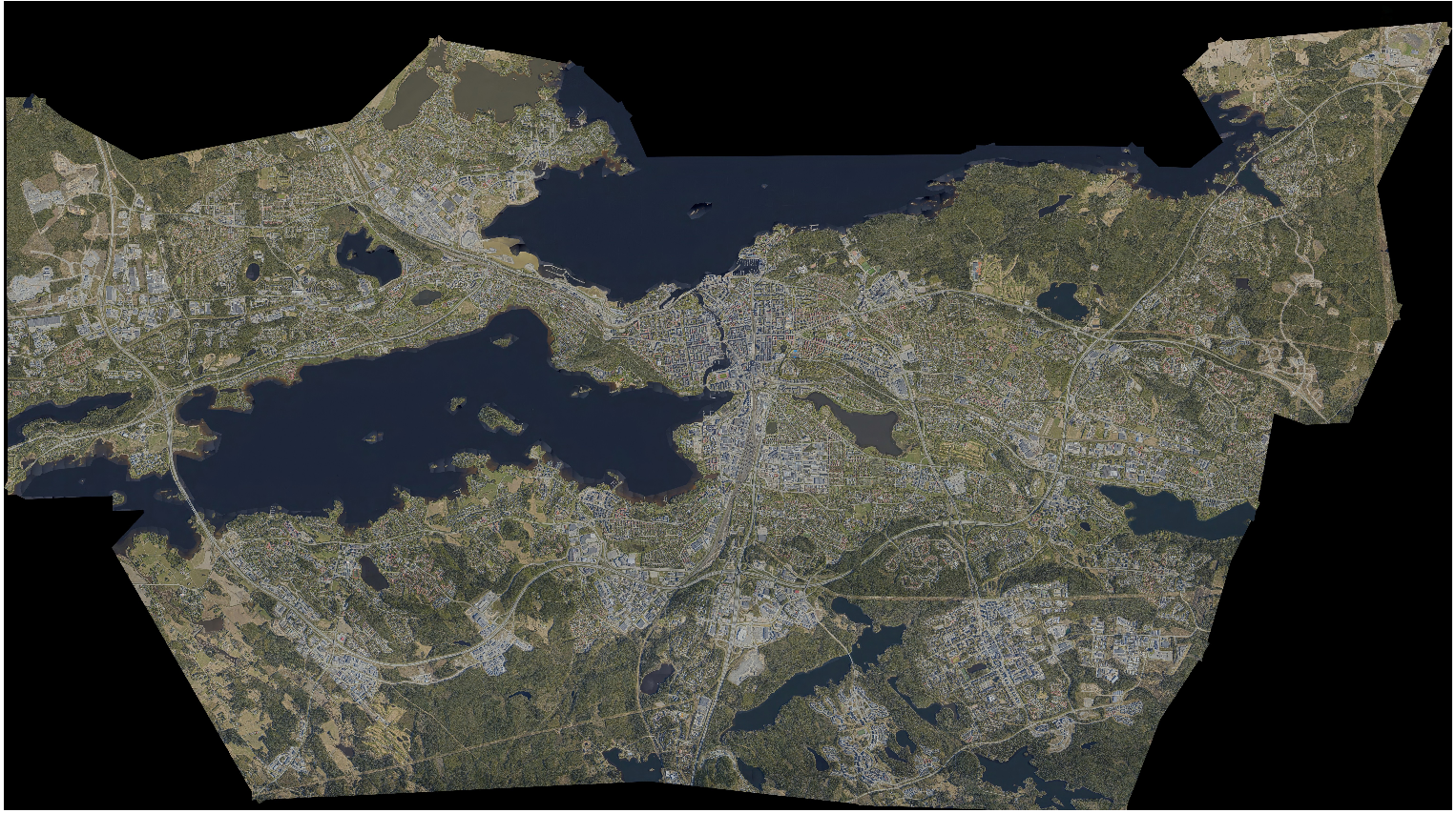
Tampereen kantakaupungin ilmakuva vuodelta 2022. Aineisto on värillisistä digitaalisista ilmakuvista orto-oikaistu kuva-aineisto. Kuvaus kattaa Tampereen kantakaupungin alueen, sekä osittain ympäryskuntia Pirkkalaa ja Nokiaa. Kuvaus on tehty 16.5-21.5.2022 aikana. Aineisto on saatavilla sekä ETRS-GK24 (EPSG:3878), että TM35FIN (EPSG:3067) tasokoordinaattijärjestelmissä. ETRS-GK24 on kuvauksen alkuperäinen koordinaatisto. Aineisto on katseltavissa Tampereen karttapalvelussa (https://kartat.tampere.fi/oskari/ ) ja on käytettävissä WMS, sekä WMTS-rajapintapalveluista, sekä ladattavissa tiedostojen latauspalvelusta (https://kartat.tampere.fi/oskari/filedl ). Karttapalvelusta ja rajapintapalveluista jaettujen aineistojen maastoresoluutio on 12.5 senttimetriä. Tiedostojen latauspalvelusta ladattavat GeoTIFF kuvien maastoresoluutio on 10.0 senttimetriä, sekä koordinaattijärjestelmä on ETSRS-GK24. Kuvauksen alkuperäinen maastoresoluutio (GSD) on 5.0 senttimetriä. Tässä tarkkuudessa kuvaus on saatavilla ECW-formaatissa Tampereen verkkolevyltä. Aineistosta vastaava yksikkö: Paikkatietoyksikkö sekä Infra/Paikkatietoyksikkö