 Paikkatietohakemisto
asNeeded
Type of resources
Available actions
Topics
Keywords
Contact for the resource
Provided by
Years
Formats
Representation types
Update frequencies
status
Service types
Scale
Resolution
-
The Arctic SDI Gazetteer Service is a service that contains authoritative place names data from the arctic area. The service can be used for searching place names and performing reverse geocoding. The service contains about 2.87 million place name locations with about 3.15 million place names. It contains data from following sources: * Canada (Natural Resources Canada, updated: 02/2018) * Denmark (including Greenland) (SDFE, updated: 05/2017) * Finland (National Land Survey of Finland, updated: 04/2017) * GEBCO Undersea feature names gazetteer (updated: 04/2019) * Iceland (National Land Survey of Iceland, updated: 08/2017) * Norway (Norwegian Mapping Authority, updated: 08/2017) * Russia (Russian Mapping Agency, updated: 04/2019) * Sweden (Swedish National Mapping Agency, updated: 05/2017) * USA (US Geological Survey, updated: 05/2017)
-
NLS-FI INSPIRE Download Service (WFS) for Geographical Names Theme is an INSPIRE compliant direct access Web Feature Service. It contains the following INSPIRE feature types: NamedPlace. The service is based on the Geographic Names Register of the National Land Survey of Finland. The dataset is administrated by the National Land Survey of Finland.
-
NLS-FI INSPIRE Download Service (WFS) for Buildings/Point is an INSPIRE compliant direct access Web Feature Service. It contains the following INSPIRE feature types: Building The service is based on the NLS-FI INSPIRE Buildings Theme Dataset. The dataset is administrated by the National Land Survey of Finland. The service contains all features from the dataset that are modelled as points.
-
NLS-FI INSPIRE Download Service (WFS) for Cadastral Parcels Theme is an INSPIRE compliant direct access Web Feature Service. It contains the following INSPIRE feature types: BasicPropertyUnit, CadastralParcel, CadastralBoundary. The service is based on the NLS-FI INSPIRE Cadastral Parcels dataset. The dataset is administrated by the National Land Survey of Finland.
-
NLS-FI INSPIRE Download Service (WFS) for Hydrography Theme is an INSPIRE compliant direct access Web Feature Service. It contains the following INSPIRE feature types: Dam Or Weir, Land-water Boundary, Rapids, Shoreline Construction, Standing Water, Watercourse. The service is based on the NLS-FI INSPIRE Hydrography Physical Waters dataset. The dataset is administrated by the National Land Survey of Finland.
-
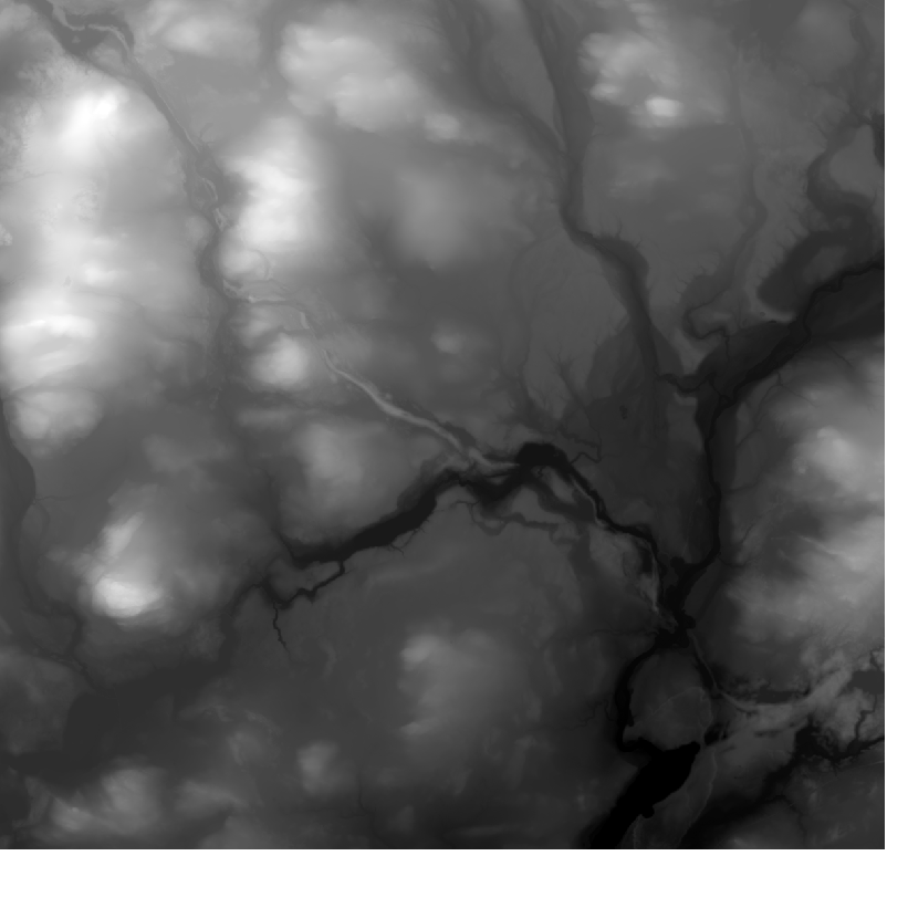
Elevation model 10 m depicts the elevation of the ground surface of the whole of Finland in relation to sea level. Its grid size is 10 m x 10 m and the accuracy of elevation data 1.4 metres. The product belongs to the open data of the National Land Survey of Finland.
-
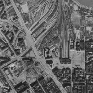
An aerial photograph is a photograph of the terrain taken from an aeroplane. The images are vertical photographs applicable to be used in mapping. The aerial photographs are reprocessed into dimensionally accurate images called orthophotos. Aerial photographs are available since the 1930s, depending on the area. Aerial photographs are available in black and white, colour and false colour. The size and accuracy of aerial photos depend on the camera, photography scale and altitude or ground sample distance (GSD). The product belongs to the open data of the National Land Survey of Finland. Aerial photographs can be ordered by pieces that cover a certain area. The latest orthophotos based on the aerial photographs can be downloaded free of charge from the File service of open data.
-
NLS-FI INSPIRE Download Service (WFS) for Administrative Units Theme is an INSPIRE compliant direct access Web Feature Service. It contains the following INSPIRE feature types: AdministrativeUnit, AdministrativeBoundary, Baseline, MaritimeZone, MaritimeBoundary. The service is based on the NLS-FI INSPIRE Administrative Units dataset. The dataset is administrated by the National Land Survey of Finland.
-
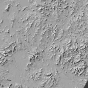
Hillshade (elevation model) is a raster dataset visualising the elevation of the terrain. There are five product versions available in which the pixel sizes are 2, 8, 32, 64, 128 and 512 metres. Pixel size 2 m has been produced of the dataset Elevation model 2 m. The other sizes have been produced of the dataset Elevation model 10 m. The material does not contain elevation values; it is a greyscale image that visualises the direction and steepness of hills. The product belongs to the open data of the National Land Survey of Finland.
-
NLS-FI INSPIRE Download Service (WFS) for Buildings/Polygon is an INSPIRE compliant direct access Web Feature Service. It contains the following INSPIRE feature types: Building The service is based on the NLS-FI INSPIRE Buildings Theme Dataset. The dataset is administrated by the National Land Survey of Finland. The service contains all features from the dataset that are modelled as polygons.