 Paikkatietohakemisto
Finland
Type of resources
Available actions
Topics
Keywords
Contact for the resource
Provided by
Years
Formats
Representation types
Update frequencies
status
Service types
Scale
-
The Finnish Uniform Coordinate System (in Finnish Yhtenäiskoordinaatisto, YKJ) has been used in biological observation mapping since the 1970s. Based on YKJ, Finland is divided in square-shaped areas, the size of which are determined according to the needs of the study. The area division used in national biomonitoring is 10 km x 10 km squares, but in some cases 1 km x 1 km and 100 m x 100 m YKJ squares are also used. This data set includes XY-lines that form square grid in four scales according to Unified Coordinate System (100 m - 100 km), with identifiers describing each square.
-
NLS-FI INSPIRE Download Service (OGC API Features) for Hydrography Theme contains the following INSPIRE feature types: Dam Or Weir, Land-water Boundary, Rapids, Shoreline Construction, Standing Water, Watercourse. The service is based on the NLS-FI INSPIRE Hydrography Physical Waters dataset. The dataset is administrated by the National Land Survey of Finland.
-
The 1:250 000 data on the soft and hard areas of the seabed supplements the seabed substrate data produced by the Geological Survey of Finland (GTK) for areas for which actual survey data is unavailable. The data covers two categories; hard and soft seabed areas. The substrate types categorised as hard seabed areas cover types ranging from gravel to boulders and exposed rock, and the substrate types for soft seabed areas cover types from silt to sand. The model is based on the marine geological survey data of GTK, the substrate observations made by the Finnish Environment Institute (SYKE) and Metsähallitus, and on the environment variable data produced by the Finnish Inventory Programme for the Underwater Marine Environment, VELMU, particularly on depth and seabed openness models. The data has undergone statistical evaluation and the ultimate model is based on expert estimates and modelling. At its most precise, the data is at a scale of 1:250 000 and the areas with a size less than 0.3 square kilometres have been removed. The substrate type information pertaining to restricted areas has been removed from the final data. A permit (AK15246) for publishing data with a similar scale, i.e. the EMODnet data, was received from the Defence Command of the Finnish Defence Forces on 28 July 2014.
-
LUOMUS WFS is an API to the geospatial information provided by the Finnish Museum of Natural History. The use of the service is free and doesn't require authentication.
-
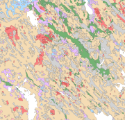
The Superficial deposits of Finland 1:200 000 (sediment polygons) contains data produced from the whole of Finland during the period 2002-2009. The data set can be used in regional planning, in military defence, in soil mapping (EU) and in joint mapping projects in various areas. The mapping scale has been 1:50 000-1:200 000. In compiling the medium-scale data set, generalised 1:20 000, 1:50 000 and 1:100 000 superficial deposits maps have been used and a new map product at a scale of 1:200 000 that is based on interpretation and field mapping. The minimum size of the sediment polygons is about six hectares. Exceptions are glaciofluvial, marginal till and hummocky moraine deposits, which are presented in the data set as areas with a surface area greater than two hectares. The blanketing peat overburden has been described in the new map product as a peat-covered area (0-0.3 m of peat), thin peat (0.3-0.6 m of peat) and thick peat (over 0.6 m of peat). Peat-covered areas, stone fields and uncovered bedrock areas have been added to the new production map by generalising the corresponding polygons in the terrain database of the National Land Survey of Finland (NLS). In connection with the generation of new production map, field observations have been gathered on the overburden thickness and the stratigraphic sequence at a depth of one metre as well as on rock exposures. Coordinate reference system of the Superficial deposits of Finland 1:200 000 (sediment polygons) was transformed in March 2013. The transformation from Finnish National Grid Coordinate System (Kartastokoordinaattijärjestelmä, KKJ) Uniform Coordinate Frame to ETRS-TM35FIN projection was done by using the three-dimensional transformation in accordance with the recommendations for the public administration JHS154.
-
The map compiles seabed samples since 1985 onwards. The data includes geographic data and metadata related to each sample, mainly based on the data produced by the Geological Survey of Finland
-
Seabed substrate 1:100 000 is one of the products produced in the EMODnet (European Marine Observation and Data network) Geology III EU project. Project provided seabed geological material from the European maritime areas. The EMODnet Geology III project (http://www.emodnet-geology.eu/) collects and harmonizes geological data from the European sea areas to support decision-making and sustainable marine spatial planning. The EMODnet Geology partnership has included 39 marine organizations from 30 countries. This data includes the EMODnet seabed substrate map at a scale of 1:100 000 from the Finnish marine areas. It is based on the data produced on a scale of 1:20 000 by the Geological Survey of Finland (GTK). The data has been harmonized and reclassified into five Folk substrate classes (clay + silt (mud), sandy clays, clayey sands, coarse sediments, mixed sediments) and bedrock. The data describes the seabed substrate from the uppermost 30 cm of the sediment column. The data have been generalized into a target scale (1:100 000). The smallest smallest cartographic unit within the data is 0.05 km2 (5 hectares). Further information about the EMODnet-Geology project III is available on the portal (http://www.emodnet-geology.eu/). Permission (AN17367) to publish the material was obtained from the Finnish Defence Office 29.9.2017.
-
Seabed substrate 1:250 000 is one of the products produced in the EMODnet (European Marine Observation and Data network) Geology EU project. Project provided seabed geological material from the European maritime areas. The EMODnet Geology project (http://www.emodnet-geology.eu/) collects and harmonizes geological data from the European sea areas to support decision-making and sustainable marine spatial planning. The EMODnet Geology partnership has included 36 marine organizations from 30 countries. This data includes the EMODnet seabed substrate map at a scale of 1:250 000 from the Finnish marine areas. It is based on the data produced on a scale of 1:20 000 by the Geological Survey of Finland (GTK), which does not cover the whole Finnish marine area yet. The seabed substrate data will be updated with a new interpreted data on a yearly basis.The data has been harmonized and reclassified into five Folk substrate classes (mud, sandy clays, clayey sands, coarse sediments, mixed sediments) and bedrock. The data describes the seabed substrate from the uppermost 30 cm of the sediment column. The data have been generalized into a target scale (1:250 000). The smallest smallest cartographic unit within the data is 0.3 km2 (30 hectares). Further information about the EMODnet-Geology project is available on the portal (http://www.emodnet-geology.eu/). Permission (AK15246) to publish the material was obtained from the Finnish Defence Office 28.07.2014
-
The Rock Geochemical Database of Finland data set describes the concentrations of major and trace elements in the bedrock of Finland. In all, 6544 samples were analysed for the total and partial concentrations of 57 elements using several different methods (XRF, ICP-MS, ICP-AES, GFAAS). The samples were taken during 1990-1995 with a mini-drill from rock that was as unaltered as possible. The sampling density varies between one sample per 30 km2 and one sample per 120 km2. The chemical analyses of the data were performed during 1992-2001. The reproducibility of the analytical results and the analytical drift were estimated using 375 duplicate sample pairs. The lowest reliable concentration was determined for each element and analytical method. In addition to the chemical concentrations, the database contains spatial data and several geological attributes for each sample. The data set and its manual were published in 2007 and they are available via the web site of the Geological Survey of Finland (GTK).
-
The data compiles seabed remote sensing situation since the 1960s. The data includes spatial data and metadata related to each survey line, mainly based on the data produced by the Geological Survey of Finland