2019
Type of resources
Available actions
Topics
Provided by
Years
Formats
Representation types
Update frequencies
Service types
Scale
Resolution
-
Kauniaisten kaupungin ylläpitämä osoiteaineisto. Jatkuva ylläpito tietokannassa, irroitus ja toimitus sopimuksen mukaan.
-
The raw materials of forest chips are small-diameter trees from thinning fellings and logging residues and stumps from final fellings. The harvesting potential consists of biomass that would be available after technical and economic constraints. Such constraints include, e.g., minimum removal of energywood per hectare, site fertility and recovery rate. Note that the techno-economic potential is usually higher than the actual availability, which depends on forest owners’ willingness to sell and competitive situation. The harvesting potentials were estimated using the sample plots of the 12th national forest inventory (NFI12) measured in the years 2014–2018. First, a large number of sound and sustainable management schedules for five consecutive ten-year periods were simulated for each sample plot using a large-scale Finnish forest planning system known as MELA (Siitonen et al. 1996; Hirvelä et al. 2017; http://mela2.metla.fi/mela/tupa/index-en.php). MELA simulations consisted of natural processes and human actions. The ingrowth, growth, and mortality of trees were predicted based on a set of distance-independent tree-level statistical models (e.g. Hynynen et al. 2002) included in MELA and the simulation of the stand (sample plot)-level management actions was based on the current Finnish silvicultural guidelines (Äijälä et al. 2014) and the guidelines for harvesting of energy wood (Koistinen et al. 2016). Future potentials were assumed to materialize when the industrial roundwood fellings followed the level of maximum sustained yield (79 mill. m3 in this calculation). The maximum sustained yield was defined such that the net present value calculated with a 4% discount rate was maximized subject to non-declining periodic industrial roundwood and energy wood removals and net incomes, and subject to the saw log removal remaining at least at the level of the first period. There were no constraints concerning tree species selection, cutting methods, age classes, or the growth/drain ratio in order to efficiently utilize the dynamics of forest structure. The potential for energywood from thinnings was calculated separately for all the energywood from thinnings (Stemwood for energy from thinnings) and for material that does not fulfill the size-requirements for pulpwood (Stemwood for energy from thinnings (smaller than pulpwood-sized trees)). Note that the decision whether pulpwood-sized thinning wood is directed to energy or industrial use, is based on the optimisation by MELA. The minimum top diameter of pulpwood in the calculation was 6.3 cm for pine (Pinus sylvestris) and 6.5 cm for spruce (Picea abies) and broadleaved species (mainly Betula pendula, B. pubescens, Populus tremula, Alnus incana, A. glutinosa and Salix spp.). The minimum length of a pulpwood log was assumed at 2.0 m. Energywood could be harvested as whole trees or as delimbed. The dry-matter loss in the supply chain was assumed at 5%. The potentials for logging residues and stumps were calculated as follows: The crown biomass removals of clear fellings were obtained from MELA. According to harvesting guidelines for energywood (Koistinen et al. 2016) mineral soils classified as sub-xeric (or weaker) and peatlands with corresponding low nutrient levels were left out from the potentials. Next, technical recovery rates were applied (70% for logging residues and 82-84% for stumps) (Koistinen et al. 2016; Muinonen et al. 2013). Finally, a dry-matter loss of 20% and 5% was assumed for residues and stumps, respectively. The techno-economical harvesting potentials were first calculated for nineteen Finnish regions and then distributed on a raster grid at 1 km × 1 km resolution by weighting with Multi-Source NFI biomasses as described by Anttila et al. (2018). The potentials represent time period 2026-2035 and are presented as average annual potentials in solid cubic metres over bark. References Äijälä O, Koistinen A, Sved J, Vanhatalo K, Väisänen P. 2014. Metsänhoidon suositukset. [Guidelines for sustainable forest management]. Metsätalouden kehittämiskeskus Tapion julkaisuja. Anttila P., Nivala V., Salminen O., Hurskainen M., Kärki J., Lindroos T.J. & Asikainen A. 2018. Regional balance of forest chip supply and demand in Finland in 2030. Silva Fennica vol. 52 no. 2 article id 9902. 20 s. https://doi.org/10.14214/sf.9902 Hirvelä, H., Härkönen, K., Lempinen, R., Salminen, O. 2017. MELA2016 Reference Manual. Natural Resources Institute Finland (Luke). 547 p. Hynynen J, Ojansuu R, Hökkä H, Salminen H, Siipilehto J, Haapala P. 2002. Models for predicting the stand development – description of biological processes in MELA system. The Finnish Forest Research Institute Research Papers. 835. Koistinen A, Luiro J, Vanhatalo K. 2016. Metsänhoidon suositukset energiapuun korjuuseen, työopas. [Guidelines for sustainable harvesting of energy wood]. Tapion julkaisuja. Muinonen E., Anttila P., Heinonen J., Mustonen J. 2013. Estimating the bioenergy potential of forest chips from final fellings in Central Finland based on biomass maps and spatially explicit constraints. Silva Fennica 47(4) article 1022. https://doi.org/10.14214/sf.1022. Siitonen M, Härkönen K, Hirvelä H, Jämsä J, Kilpeläinen H, Salminen O et al. 1996. MELA Handbook. 622. 951-40-1543-6.
-
Aineisto sisältää Vihdin kunnan ylläpitämät rakennusten osoitteet. Aineisto tuotetaan osana luparakentamista sekä osoitetietojen ylläpitoa. Aineisto päivittyy kunnan tietokannasta päivittäin. Ylläpidon tasokoordinaatistona on ETRS-GK24 (EPSG:3878).
-
Sijaintiraidetunnus on raiteelle annettu yksilöivä tunnus. Sijaintiraidetunnus on pääsääntöisesti sama kuin raiteistokaaviossa näkyvä raidenumero, jonka eteen on lisätty liikennepaikan lyhenne. Esim. HKI 001 = sama kuin Helsingin raiteistokaavion raide 001. Sijaintiraidetunnus annetaan liikennepaikkojen raiteiden lisäksi myös linjaraiteille. Yksiraiteisella linjalla linjan ratanumeron perään lisätään tieto merkittävien liikennepaikkojen välistä, esim. 006. Useampiraiteisella linjalla perään lisätään tieto raiteesta. Raidetieto ilmaistaan ilmansuunnilla, ja kolme- tai useampiraiteisella lisätään myös tieto "keskiraide". Esim. 001 HKI-KE IKR = Itäinen keskiraide ja 001 HKI-KE IsR = Itäisin raide. Sijaintiraide on osa rataosoitteistusta. Aineisto kattaa Väyläviraston omistamat rautatiet. Aineiston lähdejärjestelmä on Ratainfratietojen hallintajärjestelmän ratakohteiden hallintasovellus (RATKO).
-
Vesityspisteistä ilmoitetaan sijaintiin liittyen sijaintiraidetunnus ja ratakilometrisijainti. Vesityspisteet kuuluvat ratapihan palveluihin ja varusteisiin. Aineisto kattaa Väyläviraston omistamat rautatiet. Aineiston lähdejärjestelmä on Ratainfratietojen hallintajärjestelmän ratakohteiden hallintasovellus (RATKO).
-
Kurikan opaskartta on digitaalinen karttatuote, joka on saatavissa julkisena palveluna kaupungin verkkosivujen kautta. Se kattaa Kurikan kunnan alueen. Opaskartassa kuvataan katuverkosto ja osoitenumerot sekä maastonimistöä, maankäyttöä ja rakennuksia ja niihin liittyvää tarkentavaa nimistöä. Karttatasoilla on myös myytävät tontit sekä ajantasaiset asemakaavat kaikkien kolmen taajaman osalta. Se toimii kaupungin osoitekarttana. Kartta skaalautuu portaattomasti siten, että se näyttää suuremmilla mittakaavatasoilla enemmän kohteita. Karttaa ylläpidetään jatkuvasti ja katuverkko ja osoitteisto on ajan tasalla. Kartasta voi tulostaa otteita. Vanhaa opaskarttaa on vielä saatavilla painettuna karttana. Uuden paperikartan painamisesta ei ole tehty päätöstä. Aineiston koordinaattijärjestelmä on ETRS-GK22. Korkeusjärjestelmä N2000.
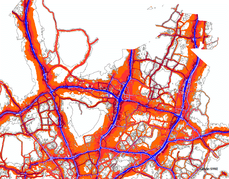
-
Helsingin kaupungin opaskartta on esitystavaltaan yleistetty opastava karttatuote, jonka ylläpitomittakaava on 1:10 000. Kartan alue kattaa koko Helsingin kaupungin maa-alueen ja osan merialueesta. Kartta sisältää mm. seuraavat tiedot: nimistö, kadut, tiet ja rautatieyhteydet, julkiset rakennukset, kerrostaloalueet, pientaloalueet, teollisuusalueet, metsä- ja pelto-alueet sekä kunnan rajat. Lisäksi kartassa on esitetty kaupunginosien ja osa-alueiden nimet sekä joitakin nähtävyyksiä. Aineistoa päivitetään jatkuvasti ja sitä ylläpidetään sähköisesti vektorimuodossa. Siitä tuotetaan sekä sähköisiä että painettuja karttatuotteita. Kartan hakuruudusto on yhtenäinen Espoon ja Vantaan opaskarttojen kanssa. Aineisto on saatavilla WMS ja WMTS-rajapintapalvelusta tasonimillä Opaskartta_Helsinki (myös WMTS) Opaskartta_Helsinki_harmaa Opaskartta_Helsinki_harvanimi Opaskartta_Helsinki_harvanimi_harmaa Opaskartta_Helsinki_4m Opaskartta_Helsinki_4m_harmaa
-
The raw materials of forest chips in Biomass Atlas are small-diameter trees from first thinning fellings and logging residues and stumps from final fellings. The harvesting potential consists of biomass that would be available after technical and economic constraints. Such constraints include, e.g., minimum removal of energywood per hectare, site fertility and recovery rate. Note that the techno-economic potential is usually higher than the actual availability, which depends on forest owners’ willingness to sell and competitive situation. The harvesting potentials were estimated using the sample plots of the 11th and 12th national forest inventory (NFI11 and NFI12) measured in the years 2013–2017. First, a large number of sound and sustainable management schedules for five consecutive ten-year periods were simulated for each sample plot using a large-scale Finnish forest planning system known as MELA (Siitonen et al. 1996; Hirvelä et al. 2017). MELA simulations consisted of natural processes and human actions. The ingrowth, growth, and mortality of trees were predicted based on a set of distance-independent tree-level statistical models (e.g. Hynynen et al. 2002) included in MELA and the simulation of the stand (sample plot)-level management actions was based on the current Finnish silvicultural guidelines (Äijälä et al. 2014) and the guidelines for harvesting of energy wood (Koistinen et al. 2016). Future potentials were assumed to materialize when the industrial roundwood fellings followed the level of maximum sustainable removals (80.7 mill. m3 in this calculation). The maximum sustainable removals were defined such that the net present value calculated with a 4% discount rate was maximized subject to non-declining periodic industrial roundwood and energy wood removals and net incomes, and subject to the saw log removal remaining at least at the level of the first period. There were no constraints concerning tree species selection, cutting methods, age classes, or the growth/drain ratio in order to efficiently utilize the dynamics of forest structure. The potential for energywood from first thinnings was calculated separately for all the wood from first thinnings (Small-diameter trees from first thinnings) and for material that does not fulfill the size-requirements for pulpwood (Small-diameter trees from first thinnings, smaller than pulpwood). The minimum top diameter of pulpwood in the calculation was 6.3 cm for pine (Pinus sylvestris) and 6.5 cm for spruce (Picea abies) and broadleaved species (mainly Betula pendula, B. pubescens, Populus tremula, Alnus incana, A. glutinosa and Salix spp.). The minimum length of a pulpwood log was assumed at 2.0 m. The potentials do not include branches. The potentials for logging residues and stumps were calculated as follows: The biomass removals of clear fellings were obtained from MELA. According to harvesting guidelines for energywood (Koistinen et al. 2016) mineral soils classified as sub-xeric (or weaker) and peatlands with corresponding low nutrient levels were left out from the potentials. Finally, technical recovery rates were applied (70% for logging residues and 82-84% for stumps) (Koistinen et al. 2016; Muinonen et al. 2013) The techno-economical harvesting potentials were first calculated for nineteen Finnish regions and then distributed on a raster grid at 1 km × 1 km resolution by weighting with Multi-Source NFI biomasses as described by Anttila et al. (2018). The potentials represent time period 2025-2034 and are presented as average annual potentials in solid cubic metres over bark. References Äijälä O, Koistinen A, Sved J, Vanhatalo K, Väisänen P. 2014. Metsänhoidon suositukset. [Guidelines for sustainable forest management]. Metsätalouden kehittämiskeskus Tapion julkaisuja. Anttila P., Nivala V., Salminen O., Hurskainen M., Kärki J., Lindroos T.J. & Asikainen A. 2018. Regional balance of forest chip supply and demand in Finland in 2030. Silva Fennica vol. 52 no. 2 article id 9902. 20 s. https://doi.org/10.14214/sf.9902 Hirvelä, H., Härkönen, K., Lempinen, R., Salminen, O. 2017. MELA2016 Reference Manual. Natural Resources Institute Finland (Luke). 547 p. Hynynen J, Ojansuu R, Hökkä H, Salminen H, Siipilehto J, Haapala P. 2002. Models for predicting the stand development – description of biological processes in MELA system. The Finnish Forest Research Institute Research Papers. 835. Koistinen A, Luiro J, Vanhatalo K. 2016. Metsänhoidon suositukset energiapuun korjuuseen, työopas. [Guidelines for sustainable harvesting of energy wood]. Tapion julkaisuja. Muinonen E., Anttila P., Heinonen J., Mustonen J. 2013. Estimating the bioenergy potential of forest chips from final fellings in Central Finland based on biomass maps and spatially explicit constraints. Silva Fennica 47(4) article 1022. https://doi.org/10.14214/sf.1022. Siitonen M, Härkönen K, Hirvelä H, Jämsä J, Kilpeläinen H, Salminen O et al. 1996. MELA Handbook. 622. 951-40-1543-6.
-
Satakunnan rakennusperintö -inventoinnin päivitys on tehty vuosina 2003–2005. Luettelon pohjana on ollut vuosina 1987–88 tehty inventointi, joka on julkaistu Satakunnan rakennusperinne -kirjassa vuonna 1990. Inventoinnissa on koottu kohde- ja aluetiedot Satakunnan maakunnallisesti merkittävistä kulttuuriympäristöistä ja rakennusperinnöstä.
-
Helsingin kaupungin WFS-palvelu on standardin mukainen WFS-rajapintapalvelu, jonka kautta voi käyttää kaupungin ylläpitämiä kartta -ja paikkatietoaineistoja vektorimuodossa. Aineistoja hallinnoi ja palvelua ylläpitää Helsingin kaupungin kaupunkimittauspalvelut. Helsingin kaupungin avoimen datan WFS-palvelun osoite on https://kartta.hel.fi/ws/geoserver/avoindata/wfs. WFS-rajapinta sisältää seuraavat Inspire-aineistot ja niitä vastaavat karttatasot Inspire-aineisto WFS-tasonimi Ajantasa-asemakaava Kaavahakemisto_kaava_voimassa Ajantasa-asemakaava Kaavahakemisto_KHn_nimenmuutoskaava_voimassa Ajantasa-asemakaava Kaavahakemisto_maanalainenkaava_voimassa Ajantasa-asemakaava Kaavahakemisto_nimenmuutoskaava_voimassa Osoitteet Helsinki_osoiteluettelo Rakennukset Rakennukset_alue Rakennukset Rakennukset_alue_rekisteritiedot Rakennukset Rakennukset_piste_rekisteritiedot Rakennuskieltokartta Rakennuskieltoalue_asemakaavan_laatimiseksi Rakennuskieltokartta Rakennuskieltoalue_yleiskaavan_laatimiseksi Yleiskaavat Osayleiskaavahakemisto_alueet
Paikkatietohakemisto