 Paikkatietohakemisto
Proterozoic
Type of resources
Available actions
Topics
Keywords
Contact for the resource
Provided by
Formats
Representation types
Update frequencies
status
Scale
-
The database consists of three components: "Published age determination”, ”Published Sm-Nd isotope data" and "Pb isotope data on galena". The "Published age determination" database is based on age determinations, which comprise predominantly U-Pb zircon data produced at the Geological Survey of Finland since 1960’s. For igneous rocks the age register contains radiometric ages mostly interpreted as primary ages. The information given consists of location data, rock type, method, mineral analyzed, age results, comments and references. "Published Sm-Nd isotope data" comprise Sm-Nd data procuded at GTK since 1981, which mostly are used to constrain the origin of crust. "Pb isotope data on galena" gives results produced at GTK since 1970's, and include also previously unpublished data.
-
The Rock Geochemical Database of Finland data set describes the concentrations of major and trace elements in the bedrock of Finland. In all, 6544 samples were analysed for the total and partial concentrations of 57 elements using several different methods (XRF, ICP-MS, ICP-AES, GFAAS). The samples were taken during 1990-1995 with a mini-drill from rock that was as unaltered as possible. The sampling density varies between one sample per 30 km2 and one sample per 120 km2. The chemical analyses of the data were performed during 1992-2001. The reproducibility of the analytical results and the analytical drift were estimated using 375 duplicate sample pairs. The lowest reliable concentration was determined for each element and analytical method. In addition to the chemical concentrations, the database contains spatial data and several geological attributes for each sample. The data set and its manual were published in 2007 and they are available via the web site of the Geological Survey of Finland (GTK).
-
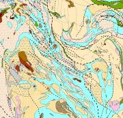
Bedrock of Finland 1:200 000 is a unified bedrock map dataset covering the whole Finland. It has been compiled by generalising the scale-free bedrock map feature dataset. The dataset consists of a lithological/stratigraphic geological unit polygon layer and linear layers, in which faults, diverse overprinting lines and dykes are represented. The dataset also includes an origin of the data and a quality estimation of the data polygon layers. The stratigraphic geological unit polygon layer includes lithological coding, geological time period and hierarchical lithostratigraphical or lithodemic classification as attributes in accordance with the Finnish database for stratigrafic geological units (Finstrati). The line layers have their own hierarchical classification. The data are at 1:200 000 scale, which indicates that the main part of the scale-free data have been generalised to correspond to a product at a scale of 1:200 000. Those areas where the source data is coarser than 1:200 000 have not been generalised. Coordinate reference system of the dataset was transformed in March 2013. The transformation from Finnish National Grid Coordinate System (Kartastokoordinaattijärjestelmä, KKJ) Uniform Coordinate Frame to ETRS-TM35FIN projection was done by using the three-dimensional transformation in accordance with the recommendations for the public administration JHS154.
-
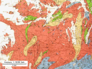
The 1:100 000 scale bedrock map data of the Geological Survey of Finland (GTK) include material produced during 1948-2007 for the needs of the mapping of mineral resources, for the sustainable exploitation of aggregate resources and for scientific research. These data include lithological information as polygons, bedrock observation points and drilling sites as well as essential tectonic observations, and information on lithological primary structures, ore minerals and metamorphic index minerals. Some 1:100 000 map sheets give both stratigraphical information as well as lithological data. An explanatory text accompanies most map sheets.
-
The GTK’s Mineral Deposit database contains all mineral deposits, occurrences and prospects in Finland. Structure of the new database was created in 2012 and it is based on global geostan-dards (GeoSciML and EarthResourceML) and classifications related to them. The database is in Oracle, data products are extracted from the primary database. During 2013 GTK’s separate mineral deposit databases (Au, Zn, Ni, PGE, U, Cu, Industrial minerals, FODD, old ore deposit database) were combined into a single entity. New database contains extensive amount of information about mineral occurrence feature along with its associated commodities, exploration activities, holding history, mineral resource and re-serve estimates, mining activity, production and geology (genetic type, host and wall rocks, min-erals, metamorphism, alteration, age, texture, structure etc.) Database will be updated whenever new data (e.g. resource estimate) is available or new deposit is found. Entries contain references to all published literature and other primary sources of data. Also figures (maps, cross sections, photographs etc.) can be linked to mineral deposit data. Data is based on all public information on the deposits available including published literature, archive reports, press releases, companies’ web pages, and interviews of exploration geologists. Database contains 33 linked tables with 216 data fields. Detailed description of the tables and fields can be found in separate document. (http://tupa/metaviite/MDD_FieldDescription.pdf) The data products extracted from the database are available on Mineral Deposits and Exploration map service (http://gtkdata.gtk.fi/MDaE/index.html) and from Hakku -service (http://hakku.gtk.fi).