 Paikkatietohakemisto
2017
Type of resources
Available actions
Topics
Keywords
Contact for the resource
Provided by
Years
Formats
Representation types
Update frequencies
Service types
Scale
Resolution
-
The Arctic SDI Gazetteer Service is a service that contains authoritative place names data from the arctic area. The service can be used for searching place names and performing reverse geocoding. The service contains about 2.87 million place name locations with about 3.15 million place names. It contains data from following sources: * Canada (Natural Resources Canada, updated: 02/2018) * Denmark (including Greenland) (SDFE, updated: 05/2017) * Finland (National Land Survey of Finland, updated: 04/2017) * GEBCO Undersea feature names gazetteer (updated: 04/2019) * Iceland (National Land Survey of Iceland, updated: 08/2017) * Norway (Norwegian Mapping Authority, updated: 08/2017) * Russia (Russian Mapping Agency, updated: 04/2019) * Sweden (Swedish National Mapping Agency, updated: 05/2017) * USA (US Geological Survey, updated: 05/2017)
-
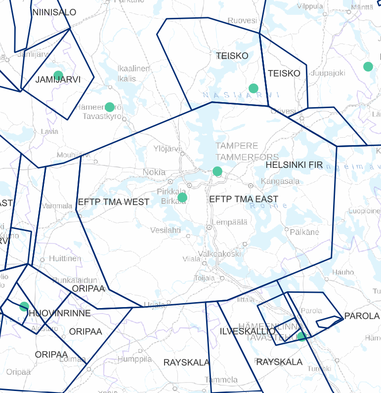
Air traffic network-product is a link-knot routing dataset compliant with INSPIRE requirements. It includes f.ex. flight routes and aerodromes. Data shall not be used for operational flight activities or flight planning. INSPIRE Air Traffic Network-product includes spatial information of air traffic network in accordance with the INSPIRE Directive. The data has been retrieved from the EAD database maintained by Eurocontrol. Information is updated regularly but is not constantly up to date. Data can be used for purposes that are in accordance with the INSPIRE Directive, but shall not be used for operational flight activities or flight planning. ANS Finland www.ais.fi –site provides information for operational flight activities or flight planning
-
This dataset represents the density of all IMO registered ships operating in the Baltic Sea. Density is defined as the number of ships crossing a 1 x 1km grid cell. It is based on HELCOM AIS (Automatic Identification System) data. The HELCOM AIS network hosts all the AIS signals received by the Baltic Sea States since 2005. The AIS Explorer allows to compare density maps of different ship types per month: http://maps.helcom.fi/website/AISexplorer/ The data was processed to produce density maps and traffic statistics. All scripts are available in GitHub: https://github.com/helcomsecretariat. The production of these maps have been carried out 2016-2017 through the HELCOM project on the assessment of maritime activities in the Baltic Sea. The underlying AIS data processing work has been co-financed by EU projects Baltic Scope (2015-2017 EASME/EMFF/2014/1.2.1.5) and Baltic Lines (2016-2019, Interreg Baltic Sea Region). In addition, the Ministry of the Environment of Finland supported the work with a special contribution in view of the use of the results in the HOLAS II process.
-
Biomassa-atlaksen yritystoiminnan jätetiedot kuvaavat ympäristölupavelvollisten yritysten vuosittain tuottamien biohajoavien jätteiden määriä 1 km ruutuaineistona. Aineisto perustuu ympäristöhallinnon valvonta- ja kuormitustietojärjestelmään (VAHTI) kirjattuihin asiakaskohtaisiin jätetietoihin, joita on jatkokäsitelty Suomen ympäristökeskuksessa. Tiedot koskevat vuotta 2015. Jätemäärät (t/v) on ilmoitettu kansallisen jäteluokituksen mukaisiin kuusinumeroisiin EWC- jäteluokkiin. Luokitus perustuu valtioneuvoston asetukseen jätteistä (179/2012, liite 4). EWC-jäteluokkakoodi (EWC=European waste code) on muotoa xx.yy.zz, jossa neljä ensimmäistä numeroa kuvaavat jätteen alkuperätoimintaa ja sen alatoimialoja ja kaksi viimeistä numeroa jätteen laatua. Kansallisessa jäteluokituksessa on toimialaluokkia kaikkiaan 20. VAHTIssa on lisäksi lietteille käytössä kirjaintarkenne A-G, joka ilmaisee lietteen käsittelytavan. VAHTI-tietojärjestelmässä asiakaskohtaiset jätetiedot kirjataan kolmeen eri jätevirtaan: lähtevä ja tuleva jätevirta sekä varastotilanne. Biomassa-atlaksen yritystoiminnan jätemäärätiedot perustuvat VAHTI-asiakkaiden lähtevään jätevirtaan kirjattuihin, biohajoavia jätejakeita koskeviin määrätietoihin (t/v). VAHTI-tietojärjestelmä ei mahdollista jätemäärien aukotonta tasetarkastelua, sillä se on pääasiallisesti kehitetty viranomaisten valvontatehtävää, ei tilastointia varten. Tämän vuoksi Biomassa-atlaksen yritystoiminnan jätemääristä on poistettu jätteenkäsittelylaitoksilta lähtevät jätemäärät. Osa jätteenkäsittelylaitoksilta lähtevistä jätemääristä tulee jo kertaalleen kirjatuksi VAHTIssa muiden yritysten lähteviin jätteisiin, ja näin ollen ne olisivat osittain päällekkäistä tietoa. Käytännössä osa yritystoiminnan jätteistä kulkee jätteenkäsittelylaitosten, kuten kuljetus- ja keräystoimintaa harjoittavien yritysten kautta hyödyntämiseen ja osa suoraan varsinaisiin jätteen käsittely-/hyödyntämispaikkoihin. Biomassa-atlaksessa yritystoiminnan jätetiedot on VAHTIn EWC-jäteluokkakoodien perusteella jaoteltu viiteen pääluokkaan: 1) eläin- ja kasvijäte, 2) liete, 3) paperi- ja pahvijäte, 4) puujäte ja 5) sekajäte. Pääluokkien lisäksi määrätiedot jakautuvat vielä tarkemmin 62 alaluokkaan. Jäteluokitus on esitetty Biomassa-atlaksen verkkosivulla. Tiedot päivitetään Biomassa-atlakseen kerran vuodessa. Viimeisin päivitys koskee vuotta 2015. Jätemäärätiedoista ei käy ilmi yksittäisen jätteentuottajan nimi. Yritysten biohajoavien jätteiden ja laskennallisesti tuotettujen yhdyskuntien biohajoavien jätteiden määrätietoja ei pidä tarkastella kartalla samanaikaisesti, koska osa tiedoista on päällekkäistä. Laskennallisiin biohajoaviin yhdyskuntajätteisiin sisältyy myös yritysten yhdyskuntajätteen kaltainen biohajoava jäte, jota esimerkiksi on toimistoista peräisin oleva paperi- ja pahvijäte ja henkilöstöruokaloista peräisin oleva biojäte.
-
Iisalmen kiinteistörekisterikartta sisältää valtakunnallisen kiinteistörekisterin mukaiset kiinteistörajat ja kiinteistötunnukset. Aineistoa ylläpitää Iisalmen kaupungin tonttipalvelut ja maanmittauslaitos.
-
Harjavallan kaupungin Karttapalvelu on WMS-rajapintapalvelu, jonka kautta on katseltavissa seuraavat karttatasot: Vesihuollon toiminta-alueet, Yleiskaavayhdistelmä, Asemakaavayhdistelmä, Pohjakartta, Virastokartta, Osoitekartta. Palvelu perustuu Harjavallan kaupungin hallinnoimiin aineistoihin. Palvelun käyttö on maksutonta ja ei vaadi autentikointia eli tunnistautumista käyttäjätunnuksen ja salasanan avulla.
-
Iisalmen ajantasa-asemakaava on koostekartta hyväksytyistä ja lainvoiman saaneista asemakaavoista. Aineisto on tuotettu lainvoimaisten asemakaavojen pohjalta ja sitä ylläpidetään Oracle- tietokannassa Trimble Locus- järjestelmässä. Kuvaustekniikan mittakaava 1:1000. Päivitys ja ylläpito jatkuvaa.
-
Kangasalan kantakartta WFS-palveluna on WFS-rajapintapalvelu, jonka kautta on saatavilla seuraavat karttatasot (suluissa tekninen nimi): Kangasalan kunnan kantakartta(Opaskartta). Palvelu perustuu Kangasalan kantakartta -aineistoon. Aineistoja hallinnoi Kangasalan kaupunki. Palvelun käyttö on maksutonta eikä vaadi autentikointia eli tunnistautumista käyttäjätunnuksen ja salasanan avulla.
-
Syken Avoin tieto-palvelussa on Atom-syöte, jonka kautta on ladattavissa Syken INSPIRE-direktiivin liitteeseen I , II ja III kuuluvat tietotuotteet.Palvelu perustuu Avoin tieto-palvelussa ladattavana oleviin paikkatietoaineistoihin. Aineistoja hallinnoi Suomen ympäristökeskus.Palvelun käyttö on maksutonta eikä vaadi autentikointia eli tunnistautumista käyttäjätunnuksen ja salasanan avulla.Aineistot kuuluvat Syken avoimiin aineistoihin (CC BY 4.0).
-
Vantaan kaupungin paikannuspalvelu on rest-rajapintapalvelu, jonka kautta on saatavilla osoite- ja kiinteistörekisteristä tuotetut paikannustiedot pistemäisinä ETRS-GK25FIN (EPSG:3879) koordinaatteina esitettynä. Data palautetaan JSON-muodossa. Palvelua voi käyttää sekä geokoodaukseen eli sijainnin hakemiseen osoitteelle tai kiinteistölle, että käänteiseen geokoodaukseen, eli lähimmän osoitteen tai kiinteistön hakemiseen sijainnin perusteella. Aineistoja hallinnoi Vantaan kaupunki. Palvelun käyttö on maksutonta eikä vaadi autentikointia eli tunnistautumista käyttäjätunnuksen ja salasanan avulla.