From 1 - 10 / 19
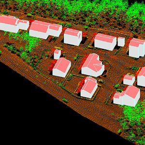
  • The 3D vectors for buildings are three-dimensional instances of the Building target category in the National Topographic Database (KMTK). The 3D vectors are produced with a high degree of automation from laser scanning data 5 p based on 2D vectors for buildings in KMTK. For the time being, data is available only from a few example areas, but the coverage will be extended to the whole of Finland as the laser scanning programme proceeds. The product belongs to the open data of the National Land Survey of Finland.

  • NLS-FI INSPIRE View Service for Buildings Theme is an INSPIRE compliant Web Map Service. It contains the following harmonized INSPIRE map layers: Building. The service is based on the NLS-FI INSPIRE Buildings Dataset. The dataset is administrated by the National Land Survey of Finland.

  • Categories  

    Please note that this dataset is deprecated from 30 May 2025 onwards. For more information, please check https://www.maanmittauslaitos.fi/en/service-messages/changes-inspire-services-concerning-buildings-and-addresses DVV INSPIRE Buildings Theme Dataset is a dataset depicting the Buildings covering the whole of Finland. It contains the following INSPIRE feature types: Buildings The elements are updated weekly. The dataset is based on "Väestötietojärjestelmän rakennus- ja huoneistotiedot" by the Digital and Population Data Services Agency (Digi- ja väestötietovirasto). Id-attribute indicates the permanent building number for buildings (VTJ-PRT). The dataset is available via the DVV INSPIRE Download Service (WFS) for Buildings Theme and it can be viewed via the DVV INSPIRE View Service (WMS) for Buildings.

  • NLS-FI INSPIRE Download Service (WFS) for Buildings/Polygon is an INSPIRE compliant direct access Web Feature Service. It contains the following INSPIRE feature types: Building The service is based on the NLS-FI INSPIRE Buildings Theme Dataset. The dataset is administrated by the National Land Survey of Finland. The service contains all features from the dataset that are modelled as polygons.

  • Categories  

    NLS-FI INSPIRE Buildings Theme Dataset is a dataset depicting the Buildings covering the whole of Finland. It contains the following INSPIRE feature types: Building The elements are updated weekly. The dataset is based on the NLS Topographic database: http://www.paikkatietohakemisto.fi/geonetwork/srv/en/main.home?uuid=cfe54093-aa87-46e2-bfa2-a20def7b036f. Id-attribute indicates the topographic database id for features (mtk-id). The dataset is available via the NLS-FI INSPIRE Download Service (WFS) for Buildings Theme and it can be viewed via the NLS-FI INSPIRE View Service (WMS) for Buildings.

  • NLS-FI INSPIRE Download Service (WFS) for Buildings/Point is an INSPIRE compliant direct access Web Feature Service. It contains the following INSPIRE feature types: Building The service is based on the NLS-FI INSPIRE Buildings Theme Dataset. The dataset is administrated by the National Land Survey of Finland. The service contains all features from the dataset that are modelled as points.

  • Aineisto sisältää päivittäistavarakauppojen ja oppilaitosten etäisyysvyöhykkeet sekä taajamien ja asemakaavoitetun alueen lievealueet. Aineistoista on saatavilla uusin vuosi. Lisätietoja: https://geoportal.ymparisto.fi/meta/julkinen/dokumentit/Etaisyysvyohykkeet.pdf

  • Aineisto sisältä lailla rakennusperinnön suojelemisesta ja sitä edeltäneellä rakennussuojelulailla suojellut kohteet ja alueet. Aineisto sisältää myös vireillä olevat sekä hylätyn päätöksen saaneet kohteet ja alueet. Aineistossa voi olla puutteita johtuen mahdollisista digitointi- ja tulkintavirheistä. Aineisto on osa ELY-keskusten tuottamia kuntakaavoituksen ja kulttuuriympäristön paikkatietoja (GISALU). Aineisto kuuluu SYKEn avoimiin aineistoihin (CC BY 4.0). Ajallinen ja sijainnillinen kattavuus vaihtelee ELY-keskuksittain. Aineisto ei kata Ahvenanmaata. Käyttötarkoitus: Tuetaan maankäyttö- ja rakennuslain tehtävien suorittamista sekä kulttuuriympäristön vaalimista ja ympäristötietoisuutta. Lisätietoja: https://geoportal.ymparisto.fi/meta/julkinen/dokumentit/GISALU.pdf

  • Paavo - Open data by postal code area contain the following geographic data: 1) Paavo postal code areas 2) Paavo postal code areas (extended to sea areas) 3) Paavo statistical data (104 variables) combined with the postal code areas There are two different versions of the map data: extending to sea areas mainly produced for statistics production, and the version produced from this for map visualisation cut with the coastline. The map data contain the surface areas of the postal code areas and the municipality codes defined for the postal code areas. The statistical data contain data on the population structure, the degree of education, the income of the inhabitants and households, the size of house-holds and life stage, buildings and dwellings, workplaces, and the main ac-tivities of the inhabitants. The statistical data are also available in the PxWeb database: https://pxdata.stat.fi/PxWeb/pxweb/en/Postinumeroalueittainen_avoin_tieto/ The data are protected. Protected data are indicated with -1. New data are updated annually in January. The data descriptions can be found in this link: http://tilastokeskus.fi/tup/paavo/paavon_aineistokuvaukset_en.html. The general Terms of Use must be observed when using the data: http://tilastokeskus.fi/org/lainsaadanto/copyright_en.html.

  • Rakennetun ympäristön tietojärjestelmä, Ryhti, kokoaa yhteen rakentamisen ja alueidenkäytön tiedot valtakunnallisesti. Tiedot syntyvät kuntien ja maakuntien liittojen perustyössä, ja ne toimitetaan valtakunnalliseen tietojärjestelmään ensisijaisesti rajapinnan kautta. Järjestelmään toimitettavat rakentamisen tiedot ovat rakentamislupa, purkamislupa, maisematyölupa ja poikkeamispäätös. Tietojen mukana toimitetaan kohteiden osoitteet. Lisäksi järjestelmässä ylläpidetään rakennuksen omistajan yhteystietoa useammasta eri lähteestä, näistä ei kuitenkaan muodostu julkisesti luotettavaa rekisteriä rakennusten omistajista. Rakentamisen tiedot ovat valtakunnallisesti saatavilla rakennetun ympäristön tietojärjestelmästä. Ennen rakennetun ympäristön tietojärjestelmän käyttöönottoa syntyneet rakennustiedot on saatu rakennetun ympäristön tietojärjestelmään Digi- ja väestötietojärjestelmän väestötietojärjestelmästä. Siirtymäajan (2025-2028) ajan kunnat voivat toimittaa rakentamisen luvituksen tiedot vielä väestötietojärjestelmään, josta ne välitetään rakennetun ympäristön tietojärjestelmään. Rakennetun ympäristön tietojärjestelmän rakennustietojen tietosisältö kuvataan yhteentoimivuusalustalla: https://tietomallit.suomi.fi/model/raklu. Väestötietojärjestelmästä peräisin olevilla rakennustiedoilla on vain osa tietosisällöstä. Aineisto on saatavilla eri palveluiden kautta. Viranomaisasiakkaille on tarjolla perustieto- ja muutostietopalvelu sekä yksittäisen kohteen kyselyrajapinta. Avoimena tietona on tarjolla OGC API Features-rajapinnat valmiista rakennuksista, hankerakennuksista sekä osoitteista. Avoin tieto on saatavilla myös Ryhti-karttapalvelusta. Muut kuin avoimet tietotuotteet edellyttävät tietolupaa ja/tai käyttösopimusta. Näistä tietotuotteista saa lisätietoja osoitteesta ryhti@syke.fi. Avoimen OGC API Features -rajapinnan ja karttapalvelussa käytössä olevien tietojen tietosisältö: https://geoportal.ymparisto.fi/meta/julkinen/dokumentit/Ryhti_rakennustiedot.pdf Lisätietoja Ryhti-järjestelmästä: https://ryhti.syke.fi/ Aineisto kuuluu SYKEn avoimiin aineistoihin (CC BY 4.0) avoimen tietosisällön osalta. ************************************************** Datasystemet för den byggda miljön Ryhti samlar uppgifter om byggande och områdesanvändning på riksnivå. Uppgifterna uppstår i kommunernas och landskapsförbundens grundläggande arbete och skickas till det riksomfattande datasystemet i första hand via gränssnittet. De uppgifter om byggande som ska skicks till systemet är bygglov, rivningslov, tillstånd för miljöåtgärder och undantagsbeslut. Adresser till objekten skickas tillsammans med uppgifterna. I systemet upprätthålls dessutom kontaktuppgifter till en byggnads ägare från flera olika källor, men dessa utgör dock inte ett offentligt tillförlitligt register över byggnadernas ägare. Uppgifterna om byggande är nationellt tillgängliga i datasystemet för den byggda miljön. Byggnadsuppgifter som uppkommit innan datasystemet för den byggda miljön togs i bruk har hämtats till datasystemet för den byggda miljön från befolkningsdatasystemet hos Myndigheten för digitalisering och befolkningsdata. Under övergångsperioden (2025–2028) kan kommunerna ännu skicka uppgifterna om bygglov till befolkningsdatasystemet, varifrån de förmedlas till datasystemet för den byggda miljön. Datainnehållet i byggnadsuppgifterna i Datasystemet för den byggda miljön beskrivs på interoperabilitetsplattformen: https://tietomallit.suomi.fi/model/raklu. Byggnadsuppgifter från befolkningsdatasystemet innehåller endast en del av datainnehållet. Materialet finns tillgängligt via olika tjänster. För myndighetskunder erbjuds den grundläggande informationstjänsten och ändringsdatatjänsten samt ett förfrågningsgränssnitt för ett enskilt objekt. Som öppen information erbjuds gränssnitten OGC API Features för färdiga byggnader, projektbyggnader och adresser. Öppen information finns också tillgänglig i Ryhti-karttjänsten. Andra än öppna dataprodukter förutsätter datatillstånd och/eller användningsavtal. Mer information om dessa dataprodukter fås på adressen ryhti@syke.fi. Datainnehållet i det öppna gränssnittet OGC API Features och de uppgifter som används i karttjänsten: https://geoportal.ymparisto.fi/meta/julkinen/dokumentit/Ryhti_rakennustiedot.pdf (på finska) Mer information om Ryhti-systemet: https://ryhti.syke.fi/sv/ Materialet hör till Finlands miljöcentrals öppna material (CC BY 4.0), för den del som omfattar öppet material. ********************************************************* The purpose of Ryhti, the Built Environment Information System, is to collect construction and land use data at a national scale. This data is generated as part of the basic tasks of municipalities and regional councils, and it is submitted to the national information system primarily via an API. The construction data submitted to the system includes building permits, demolition permits, landscaping permits, and deviation decisions. The data includes the address of each site. In addition, the system maintains the contact information of building owners, obtained from several different sources. However, the system does not constitute a publicly reliable register of building owners. The Built Environment Information System serves as a national-level construction data repository. Any construction data created prior to the introduction of the Built Environment Information System has been retrieved from the Population Information System, which is maintained by the Digital and Population Data Services Agency. During the transition period (2025–2028), municipalities may submit their construction permit data to the Population Information System, which will then forward it to the Built Environment Information System. The building data content in the Built Environment Information System is described in more detail on the interoperability platform: https://tietomallit.suomi.fi/model/raklu. The building data from the Population Information System only contains part of the data content. The dataset is available through different services. Official customers can use a basic data and modified data service, as well as a query API for individual sites. Open data on completed buildings, project buildings, and addresses is available via OGC API Features interfaces. Open data is also available in the Ryhti map service. Non-open data products require a data access permit and/or user agreement. For more information about these data products, send an email to ryhti@syke.fi. Data content of the open OGC API Features interface and the data used in the map service: https://geoportal.ymparisto.fi/meta/julkinen/dokumentit/Ryhti_rakennustiedot.pdf (available in Finnish) More information about the Ryhti system: https://ryhti.syke.fi/en The open data content of the dataset is part of SYKE’s open data (CC BY 4.0).