Paikkatietohakemisto
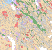
Superficial deposits of Finland 1:200 000 (sediment polygons)
The Superficial deposits of Finland 1:200 000 (sediment polygons) contains data produced from the whole of Finland during the period 2002-2009. The data set can be used in regional planning, in military defence, in soil mapping (EU) and in joint mapping projects in various areas. The mapping scale has been 1:50 000-1:200 000. In compiling the medium-scale data set, generalised 1:20 000, 1:50 000 and 1:100 000 superficial deposits maps have been used and a new map product at a scale of 1:200 000 that is based on interpretation and field mapping. The minimum size of the sediment polygons is about six hectares. Exceptions are glaciofluvial, marginal till and hummocky moraine deposits, which are presented in the data set as areas with a surface area greater than two hectares. The blanketing peat overburden has been described in the new map product as a peat-covered area (0-0.3 m of peat), thin peat (0.3-0.6 m of peat) and thick peat (over 0.6 m of peat). Peat-covered areas, stone fields and uncovered bedrock areas have been added to the new production map by generalising the corresponding polygons in the terrain database of the National Land Survey of Finland (NLS). In connection with the generation of new production map, field observations have been gathered on the overburden thickness and the stratigraphic sequence at a depth of one metre as well as on rock exposures.
Coordinate reference system of the Superficial deposits of Finland 1:200 000 (sediment polygons) was transformed in March 2013. The transformation from Finnish National Grid Coordinate System (Kartastokoordinaattijärjestelmä, KKJ) Uniform Coordinate Frame to ETRS-TM35FIN projection was done by using the three-dimensional transformation in accordance with the recommendations for the public administration JHS154.
Simple
- Alternate title
-
Maaperän yleiskartta
- Date (Publication)
- 2010-01-01
- Presentation form
- digitalGeographicInfo
- Purpose
-
The Superficial deposits of Finland 1:200 000 (sediment polygons) is suitable for use at a general scale (medium scale) in land-use planning, in the mapping and inventory of the natural resources of land areas, in environmental management, in agriculture and forestry and in education as well as in scientific and applied research. The scale of use of the map data set is 1:100 000-1:250 000.
- Credit
-
Maa- ja elintarviketalouden tutkimuskeskus
- Credit
-
Maanmittauslaitos
- Credit
-
Metsäntutkimuslaitos
- Status
- Completed
- Point of contact
-
Organisation name Individual name Electronic mail address Role Geological Survey of Finland
Owner
-
Geosanasto
-
-
Soils
-
Outcrops
-
Bedrock
-
Sediments
-
Coarse-grained materials
-
Fine-grained materials
-
Clay
-
Gyttja
-
Organic sediments
-
Peat
-
Water
-
- Place
-
-
Finland
-
Finland
-
- Discipline
-
-
Geologic maps
-
Surficial geology maps
-
Geologic maps
-
Surficial geology maps
-
-
GEMET - INSPIRE themes, version 1.0
-
-
Geology
-
-
Paikkatietohakemiston asiasanasto
-
-
Not-Inspire
-
avoindata.fi
-
- Temporal
-
-
Quaternary
-
- Access constraints
- Other restrictions
- Other constraints
- no limitations to public access
- Use constraints
- Other restrictions
- Other constraints
- Attribution 4.0 International (CC BY 4.0)
- Spatial representation type
- Vector
- Denominator
- 200000
- Language
- Finnish
- Topic category
-
- Geoscientific information
))
- Reference system identifier
- EPSG / ETRS89 / ETRS-TM35FIN (EPSG:3067) / 7.4
- Topology level
- Geometry only
- Distribution format
-
Name Version ESRI file gdb
10.1
- OnLine resource
-
Protocol Linkage Name WWW:LINK-1.0-http--link
http://hakku.gtk.fi/fi/locations/search?location_id=3 WWW:LINK-1.0-http--link
http://gtkdata.gtk.fi/Maankamara/index.html Maankamara
- File identifier
- ade1283b-0e69-4166-a52a-261d04f32cd0 XML
- Metadata language
- Finnish
- Character set
- 8859 Part 15
- Hierarchy level
- Dataset
- Hierarchy level name
-
Maaperä 1:200 000 (maalajit)
- Date stamp
- 2024-02-19T15:08:34
- Metadata author
-
Organisation name Individual name Electronic mail address Role Geological Survey of Finland
Point of contact
- Other language
-
Language Character encoding English 8859 Part 15 Finnish UTF8