 Paikkatietohakemisto
200000
Type of resources
Available actions
Topics
Keywords
Contact for the resource
Provided by
Years
Formats
Representation types
Update frequencies
status
Scale
-
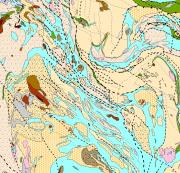
Bedrock of Finland 1:200 000 is a unified bedrock map dataset covering the whole Finland. It has been compiled by generalising the scale-free bedrock map feature dataset. The dataset consists of a lithological/stratigraphic geological unit polygon layer and linear layers, in which faults, diverse overprinting lines and dykes are represented. The dataset also includes an origin of the data and a quality estimation of the data polygon layers. The stratigraphic geological unit polygon layer includes lithological coding, geological time period and hierarchical lithostratigraphical or lithodemic classification as attributes in accordance with the Finnish database for stratigrafic geological units (Finstrati). The line layers have their own hierarchical classification. The data are at 1:200 000 scale, which indicates that the main part of the scale-free data have been generalised to correspond to a product at a scale of 1:200 000. Those areas where the source data is coarser than 1:200 000 have not been generalised. Coordinate reference system of the dataset was transformed in March 2013. The transformation from Finnish National Grid Coordinate System (Kartastokoordinaattijärjestelmä, KKJ) Uniform Coordinate Frame to ETRS-TM35FIN projection was done by using the three-dimensional transformation in accordance with the recommendations for the public administration JHS154.
-
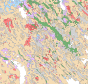
The Superficial deposits of Finland 1:200 000 (sediment polygons) contains data produced from the whole of Finland during the period 2002-2009. The data set can be used in regional planning, in military defence, in soil mapping (EU) and in joint mapping projects in various areas. The mapping scale has been 1:50 000-1:200 000. In compiling the medium-scale data set, generalised 1:20 000, 1:50 000 and 1:100 000 superficial deposits maps have been used and a new map product at a scale of 1:200 000 that is based on interpretation and field mapping. The minimum size of the sediment polygons is about six hectares. Exceptions are glaciofluvial, marginal till and hummocky moraine deposits, which are presented in the data set as areas with a surface area greater than two hectares. The blanketing peat overburden has been described in the new map product as a peat-covered area (0-0.3 m of peat), thin peat (0.3-0.6 m of peat) and thick peat (over 0.6 m of peat). Peat-covered areas, stone fields and uncovered bedrock areas have been added to the new production map by generalising the corresponding polygons in the terrain database of the National Land Survey of Finland (NLS). In connection with the generation of new production map, field observations have been gathered on the overburden thickness and the stratigraphic sequence at a depth of one metre as well as on rock exposures. Coordinate reference system of the Superficial deposits of Finland 1:200 000 (sediment polygons) was transformed in March 2013. The transformation from Finnish National Grid Coordinate System (Kartastokoordinaattijärjestelmä, KKJ) Uniform Coordinate Frame to ETRS-TM35FIN projection was done by using the three-dimensional transformation in accordance with the recommendations for the public administration JHS154.
-

The map sheet division is a system created for printing maps, which covers map sheet codes, map scales and map sheet sizes. Today, map sheet division is also used for other purposes. It is also possible to download other NLS datasets in addition to maps in accordance with map sheet division. The map sheet division TM35, which is based on the projected coordinate reference system ETRS-TM35FIN is in use today. Before 2007, a map sheet division that was based on the KKS coordinate reference system was used. The TM35 map sheet division consists of 7 different grid sizes, the smallest scale is 1:200,000 and the largest is 1:5000. An explanation of how the grids are further split into more detailed grids and the principles of map sheet numbering is on the National Land Survey website (in Finnish) https://www.maanmittauslaitos.fi/kartat-ja-paikkatieto/kartat/osta-kartta/nain-loydat-oikean-karttalehden. The attribute data of the grids include map sheet number, the area of a square on the grid, perimeter and the coordinates of the centre of the square. The map sheet division is available as a file in vector format and through our contract-based WMTS service in raster format. In addition, you can view it in the geoportal Paikkatietoikkuna. The product is a part of the open data of the National Land Survey.
-
Karttataso kuvaa Itämeren ekosysteemin tilaa kokonaisvaltaisesti perustuen HELCOM HOLAS luokittelutyökaluun. Kokonaisvaltainen luokitus perustuu kolmeen temaattiseen arviointiin: Biodiversiteetti tilan arviointityökalu (BEAT), kemikaalitilan arviointityökalu (CHASE) ja rehevöitymistilan luokittelutyökalu (HEAT). Interpoloitu kartta on tuotettu kolmessa vaiheessa: 1) Rannikkoalueen arviointiyksiöt ovat interpoloitu 2) Avomerialueet ovat interpoloitu ja 3) Rannikko- ja avomerialueet ovat yhdistetty käyttäen pehmennys (smooth) funktiota. Tarkempaa tietoa arvioinnin tuottamisesta saa julkaisusta:http://www.helcom.fi/stc/files/Publications/Proceedings/bsep122.pdf Data on ladattavissa HELCOM Map and Data Service:n kautta osoitteesta: http://maps.helcom.fi/website/mapservice/index.html.
-
Etelä-Pohjanmaan maakuntakaava 2050 on kokonaismaakuntakaava, joka sisältää kaikki alueidenkäytön teemat eli aluerakenteen, liikenteen, teknisen huollon verkostojen, viherrakenteen, luonnonvarojen, energiatuotannon ja kulttuuriympäristöjen teemat sekä alueelliset kehittämisperiaatteet. Etelä-Pohjanmaan maakuntakaava 2050 on hyväksytty maakuntavaltuustossa 16.9.2024 ja kuulutettu maankäyttö- ja rakennuslain 201 §:n mukaisesti voimaan maakuntahallituksen päätöksellä 20.12.2024. Maakuntakaava on laadittu mittakaavassa 1:200 000. Kaava on tässä aineistossa visualisoitu ns. HAME-mallin mukaan, joka poikkeaa hyväksytyn ja voimaan kuulutetun maakuntakaavan visualisoinnista (epliitto.fi/aluesuunnittelu-ja-liikenne/etela-pohjanmaan-maakuntakaava-2050/). Visualisointi perustuu HAME-hankkeessa (Harmonisoidut maakuntakaavat e-palveluiksi) kehitettyihin ja yhteisesti sovittuihin maakuntakaavamerkintöihin. Lisätiedot HAME-tietomallista: https://www.lounaistieto.fi/maakuntakaavat/
-
Karttataso kuvaa Itämeren laivaliikennettä perustuen AIS (Automatic Identification System) järjestelmään. Kartassa esitetty laivaliikenne on kuukausittainen keskiarvo laskettuna vuodelle 2011. Pistemäinen AIS-tiheysaineisto on muutettu 2500x2500 m resoluution rasteriaineistoksi. Data on ladattavissa rasterimuodossa HELCOM Map and Data Service:n kautta osoitteesta: http://maps.helcom.fi/website/mapservice/index.html.
-
Karttataso kuvaa Itämeren kemikaali tilaa perustuen HELCOM CHASE luokittelutyökaluun. Interpoloitu kartta on tuotettu kolmessa vaiheessa: 1) Rannikkoalueen arviointiyksiöt ovat interpoloitu 2) Avomerialueet ovat interpoloitu ja 3) Rannikko- ja avomerialueet ovat yhdistetty käyttäen pehmennys (smooth) funktiota. Kartan tuottamiseen käytetty lähtöaineisto on peräisin monitorointidataan vuosilta 1999-2007 eri kemikaalien, radionuklidi cesium-137:n pitoisuuksiin sekä tiettyihin biologisiin indikaattoreihin. Tarkempaa tietoa arvioinnin tuottamisesta saa julkaisuista: http://www.helcom.fi/stc/files/Publications/Proceedings/bsep120B.pdf http://www.helcom.fi/stc/files/Publications/Proceedings/bsep122.pdf Data on ladattavissa HELCOM Map and Data Service:n kautta osoitteesta: http://maps.helcom.fi/website/mapservice/index.html.
-
Karttataso kuvaa Itämeren biodiversiteetin tilaa perustuen HELCOM BEAT luokittelutyökaluun. Interpoloitu kartta on tuotettu kolmessa vaiheessa: 1) Rannikkoalueen arviointiyksiöt ovat interpoloitu 2) Avomerialueet ovat interpoloitu ja 3) Rannikko- ja avomerialueet ovat yhdistetty käyttäen pehmennys (smooth) funktiota. Tarkempaa tietoa arvioinnin tuottamisesta saa julkaisuista: http://www.helcom.fi/stc/files/Publications/Proceedings/bsep116B.pdf http://www.helcom.fi/stc/files/Publications/Proceedings/bsep122.pdf Data on ladattavissa HELCOM Map and Data Service:n kautta osoitteesta: http://maps.helcom.fi/website/mapservice/index.html.
-
Karttataso kuvaa Itämeren ympäristöpaineiden aiheuttamia vaikutuksia indeksinä (HELCOM BSII). Kartta perustuu 52 eri karttaan ihmistoiminnan tuottamasta ympäristöpaineesta. Aktiviteettien luokittelu perustuu EU:n meristrategiadirektiivin Liitteen 3, Taulukon 2 mukaiseen jakoon. Eri ympäistöpaineiden aiheuttamien vaikutusten voimakkuus meriympäristön 14 eri komponenttiin (valoisa ja valoton vesikerros, hiekka-, muta- ja kovat pohjat, meriajokasniityt, simpukkayhteisöt, turskan lisääntymis- ja poikastuotantoalueet, merilintujen talvehtimisalueet, hylkeiden ja pyöriäisten levinneisyysalueet) luokiteltiin asiantuntija-arvioiden perusteella. Lisätietoa aineistosta ja menetelmästä löytyy: http://www.helcom.fi/stc/files/Publications/Proceedings/bsep125.pdf Karttadata on ladattavissa HELCOM Map and Data Service:n kautta osoitteesta: http://maps.helcom.fi/website/mapservice/index.html
-
Aineisto sisältää Pohjois-Savon voimassa olevat maakuntakaavat. Aineiston on tuottanut Pohjois-Savon liitto. Pohjois-Savossa on voimassa kaavamerkintöjä kolmesta maakuntakaavasta: Kuopion seudun maakuntakaava (2008) Siilinjärven Yaran T/Ek 13.800 ja T/kem 13.803 merkintöjen osalta, Pohjois-Savon maakuntakaavan 2040, 1. vaihe (2019) päivityksin sekä Pohjois-Savon maakuntakaavan 2040, 2. vaihe (2025). Lisätietoja: maakuntasuunnittelija Mikko Rummukainen, 044 714 2655, mikko.rummukainen@pohjois-savo.fi. Aineisto on visualisoitu HAME-tietomallin mukaan, joka poikkeaa vahvistettujen maakuntakaavojen visualisoinnista. HAME-visualisointi perustuu HAME-hankkeessa (Harmonisoidut maakuntakaavat e-palveluiksi) kehitettyihin ja yhteisesti sovittuihin maakuntakaavamerkintöihin. Lisätietoa HAME-hankkeesta: http://www.syke.fi/hankkeet/hame