 Paikkatietohakemisto
Bedrock
Type of resources
Available actions
Topics
Keywords
Contact for the resource
Provided by
Formats
Representation types
Update frequencies
status
Scale
-
The database consists of three components: "Published age determination”, ”Published Sm-Nd isotope data" and "Pb isotope data on galena". The "Published age determination" database is based on age determinations, which comprise predominantly U-Pb zircon data produced at the Geological Survey of Finland since 1960’s. For igneous rocks the age register contains radiometric ages mostly interpreted as primary ages. The information given consists of location data, rock type, method, mineral analyzed, age results, comments and references. "Published Sm-Nd isotope data" comprise Sm-Nd data procuded at GTK since 1981, which mostly are used to constrain the origin of crust. "Pb isotope data on galena" gives results produced at GTK since 1970's, and include also previously unpublished data.
-
The Rock Geochemical Database of Finland data set describes the concentrations of major and trace elements in the bedrock of Finland. In all, 6544 samples were analysed for the total and partial concentrations of 57 elements using several different methods (XRF, ICP-MS, ICP-AES, GFAAS). The samples were taken during 1990-1995 with a mini-drill from rock that was as unaltered as possible. The sampling density varies between one sample per 30 km2 and one sample per 120 km2. The chemical analyses of the data were performed during 1992-2001. The reproducibility of the analytical results and the analytical drift were estimated using 375 duplicate sample pairs. The lowest reliable concentration was determined for each element and analytical method. In addition to the chemical concentrations, the database contains spatial data and several geological attributes for each sample. The data set and its manual were published in 2007 and they are available via the web site of the Geological Survey of Finland (GTK).
-
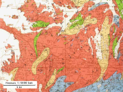
The 1:100 000 scale bedrock map data of the Geological Survey of Finland (GTK) include material produced during 1948-2007 for the needs of the mapping of mineral resources, for the sustainable exploitation of aggregate resources and for scientific research. These data include lithological information as polygons, bedrock observation points and drilling sites as well as essential tectonic observations, and information on lithological primary structures, ore minerals and metamorphic index minerals. Some 1:100 000 map sheets give both stratigraphical information as well as lithological data. An explanatory text accompanies most map sheets.
-
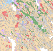
Bedrock of Finland 1:200 000 is a unified bedrock map dataset covering the whole Finland. It has been compiled by generalising the scale-free bedrock map feature dataset. The dataset consists of a lithological/stratigraphic geological unit polygon layer and linear layers, in which faults, diverse overprinting lines and dykes are represented. The dataset also includes an origin of the data and a quality estimation of the data polygon layers. The stratigraphic geological unit polygon layer includes lithological coding, geological time period and hierarchical lithostratigraphical or lithodemic classification as attributes in accordance with the Finnish database for stratigrafic geological units (Finstrati). The line layers have their own hierarchical classification. The data are at 1:200 000 scale, which indicates that the main part of the scale-free data have been generalised to correspond to a product at a scale of 1:200 000. Those areas where the source data is coarser than 1:200 000 have not been generalised. Coordinate reference system of the dataset was transformed in March 2013. The transformation from Finnish National Grid Coordinate System (Kartastokoordinaattijärjestelmä, KKJ) Uniform Coordinate Frame to ETRS-TM35FIN projection was done by using the three-dimensional transformation in accordance with the recommendations for the public administration JHS154.
-
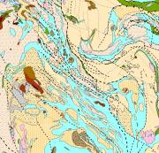
The Superficial deposits of Finland 1:200 000 (sediment polygons) contains data produced from the whole of Finland during the period 2002-2009. The data set can be used in regional planning, in military defence, in soil mapping (EU) and in joint mapping projects in various areas. The mapping scale has been 1:50 000-1:200 000. In compiling the medium-scale data set, generalised 1:20 000, 1:50 000 and 1:100 000 superficial deposits maps have been used and a new map product at a scale of 1:200 000 that is based on interpretation and field mapping. The minimum size of the sediment polygons is about six hectares. Exceptions are glaciofluvial, marginal till and hummocky moraine deposits, which are presented in the data set as areas with a surface area greater than two hectares. The blanketing peat overburden has been described in the new map product as a peat-covered area (0-0.3 m of peat), thin peat (0.3-0.6 m of peat) and thick peat (over 0.6 m of peat). Peat-covered areas, stone fields and uncovered bedrock areas have been added to the new production map by generalising the corresponding polygons in the terrain database of the National Land Survey of Finland (NLS). In connection with the generation of new production map, field observations have been gathered on the overburden thickness and the stratigraphic sequence at a depth of one metre as well as on rock exposures. Coordinate reference system of the Superficial deposits of Finland 1:200 000 (sediment polygons) was transformed in March 2013. The transformation from Finnish National Grid Coordinate System (Kartastokoordinaattijärjestelmä, KKJ) Uniform Coordinate Frame to ETRS-TM35FIN projection was done by using the three-dimensional transformation in accordance with the recommendations for the public administration JHS154.
-
The Superficial deposits of Finland 1:1 000 000 is based on 'Quaternary Deposits of Finland and Northwestern Part of Russian Federation and their Resources (Sheet 1, Western part)' mapping data. This data is also based on the 1984 map 'Quaternary Deposits of Finland' (1:1 000 000) in the “Geologia” (Geology) folio of the Atlas of Finland, 5th edition (123-126, 1990). Joint scientific and technical planning for the map of the 'Quaternary Deposits of Finland and Northwestern Part of Russian Federation and their Resources' was begun in 1987 while work on the map started in 1988. No field mapping was done for the map, rather the 1:1 000 000 Quaternary map printed in 1984 was supplemented with new data partly obtained from rock aggregate studies and partly from information on superficial deposits gathered in other superficial mapping projects. The map 'Quaternary Deposits of Finland and Northwestern Part of Russian Federation and their Resources' was printed in 1993. The map shows the superficial deposits with colours and symbols and these are classed according to their mode of geological development. The deposit classes are as follows: pre-Quaternary bedrock exposures (no Quaternary layers); boulder field, physically weathered bedrock; gravelly and sandy till; silty till; clayey till; hummocky moraine ; moraine complex; esker, delta, sandur, sorted marginal formation; interlobate formation (esker); till-covered esker / other till-covered gravel and sand deposit; gravel and sand deposit peripheral to eskers; littoral gravel and sand deposit; fluvial deposit; homogeneous clay and silt deposit; layered (varved) clay and silt deposit; peat deposit. Additionally, drumlins, end moraines, aeolian deposits, and sites of gravel, sand, clay and peat extraction as well as gold panning areas have been indicated with symbols. The data set was converted to a digital format to meet the needs of the OneGeology-Europe Project for a printed map in 2009. This data did not include drumlins, end moraines, aeolian deposits, and more important sites for the exploitation of superficial deposits (sites of gravel, sand, clay and peat extraction as well as gold panning areas). In accordance with the 1984 Quaternary map (1:1 000 000) the minimum size of the deposit polygon is generally one square kilometre. In nature the size of superficial sedimentary deposits is usually smaller than one square kilometre and therefore the most common deposit type in the area is shown in the polygon. In places, deposits smaller than a square kilometre that are significant from a superficial perspective have been noted. As a rule, the narrowest point of the deposit polygon was 0.5 km and in important cases, for example on eskers, 0.3 km. As an exception, the size of small eskers has been exaggerated. Coordinate reference system of the Superficial deposits of Finland 1:1 000 000 was transformed in October 2013. The transformation from Finnish National Grid Coordinate System (Kartastokoordinaattijärjestelmä, KKJ) Uniform Coordinate Frame to ETRS-TM35FIN projection was done by using the three-dimensional transformation in accordance with the recommendations for the public administration JHS154. The water layer which were used in the OneGeology-Europe project was replaced in 2015 with the more accurate water layer of the Topographic database 1:55 0000-1:500 000 (DVE3) from ICT Agency HALTIK.