 Paikkatietohakemisto
Waterbodies
Type of resources
Topics
Keywords
Contact for the resource
Provided by
Formats
Representation types
Update frequencies
Service types
Scale
-
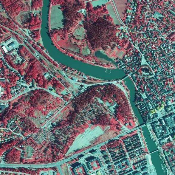
NLS Orthophotos are an aerial photo dataset covering the whole of Finland. An orthophoto is a combination of several individual aerial photos. The geometry of the orthophotos corresponds to a map. The aerial photo data set in orthophoto format is available as - the most recent data set consisting of the most recent aerial photos available. The most recent data is usually 1–3 years old. - old aerial photos, consisting of data sets that are older than the most recent data set. The oldest aerial photos were taken in the 1930s. New data is added to the data set continuously. NLS Orthophotos are updated every 3 years (in Northern Lapland 12 years). Different versions of orthophoto products: - Ortophoto - Ortophoto, false colour - Ortophoto, forest ortho - Ortophoto, natural disasters In addition, there is an index map available presenting the year, when the newest photo was taken in each square. The product belongs to the open data of the National Land Survey of Finland.
-
Palvelu tarjoaa tietoja muun muassa liikenneverkoista, rakennuksista ja rakenteista, hallintorajoista, nimistöstä, maankäytöstä, vesistöistä ja korkeussuhteista. Aineistolähteenä on Maanmittauslaitoksen Maastotietokanta, jonka kohteita pidetään jatkuvasti ajan tasalla. Aineistot ovat Maanmittauslaitoksen avoimen tietoaineiston Nimeä CC 4.0 -lisenssin alaisia. Palvelu tarjotaan avoimena rajapintana, jonka käyttö on maksutonta. Käyttäjä tunnistetaan API-avaimella. Lue lisää Maanmittauslaitoksen avoimen rajapinnan käyttöehdoista ja API-avaimen luomisesta ja käyttämisestä. https://www.maanmittauslaitos.fi/rajapinnat/api-avaimen-ohje
-

The Topographic database is a dataset depicting the terrain of all of Finland. The key objects in the Topographic database are the road network, buildings and constructions, administrative borders, geographic names, land use, waterways and elevation. Aerial photographs, scanning data and data provided by other data providers are utilised in updating the Topographic database. The updating is done in close cooperation with the municipalities. Field checks in the terrain are also needed to some extent, mostly as regards the classification of features. The topographic database is used in the production of other map products and in various optimisation tasks. The product belongs to the open data of the National Land Survey of Finland.