 Paikkatietohakemisto
Gyttja
Type of resources
Topics
Keywords
Contact for the resource
Provided by
Formats
Representation types
Update frequencies
status
Scale
-
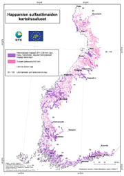
The data on acid sulfate soils in 1:250 000 scale contains material generated since 2009 on the existence and properties of sulfate soils on the Finnish coastal areas and their drainage basins roughly up to the highest shoreline of the ancient Litorina Sea. The data contains the following levels: - Acid sulfate soils, 1:250 000 maps o Probability of the existence of acid sulfate soils o Probability of the existence of coarse-grained acid sulfate soils - Acid sulfate soils, profile points on 1:250 000 maps - Acid sulfate soils, survey points on 1:250 000 maps - Acid sulfate soils, profile point fact sheets on 1:250 000 maps The data gives a general outlook on the properties and occurrence of acid sulfate soils. The regional existence of sulfate soils is presented as a regional map plane using a four-tiered probability classification: high, moderate, low and very low. These classifications are complemented with regional planar data on whether the acid sulfate soil is coarse-grained, since its properties are significantly different from typical fine-grained sulfate soils. The drilling point (profile points and survey points) observations and analysis data are presented as point-like data on the map and as profile point fact sheets linked to points The survey data can be utilised, for example, in the planning and execution of land use and water management as required by environmental protection and land use. The survey scale is 1:20 000 – 1:50 000. The observation point density is 1–2 / 2 km² on average, and the minimum area of the region-like pattern is usually 6 hectares. The surveys collected data on the lithostratigraphy, existence of sulfide and the depth where found, and the soil pH values. The survey depth is three metres. The laboratory analyses included the determination of elements with the ICP-OES method and pH incubation. The data is published in GTK’s Acid Sulfate Soils map service.
-
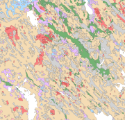
The Superficial deposits of Finland 1:200 000 (sediment polygons) contains data produced from the whole of Finland during the period 2002-2009. The data set can be used in regional planning, in military defence, in soil mapping (EU) and in joint mapping projects in various areas. The mapping scale has been 1:50 000-1:200 000. In compiling the medium-scale data set, generalised 1:20 000, 1:50 000 and 1:100 000 superficial deposits maps have been used and a new map product at a scale of 1:200 000 that is based on interpretation and field mapping. The minimum size of the sediment polygons is about six hectares. Exceptions are glaciofluvial, marginal till and hummocky moraine deposits, which are presented in the data set as areas with a surface area greater than two hectares. The blanketing peat overburden has been described in the new map product as a peat-covered area (0-0.3 m of peat), thin peat (0.3-0.6 m of peat) and thick peat (over 0.6 m of peat). Peat-covered areas, stone fields and uncovered bedrock areas have been added to the new production map by generalising the corresponding polygons in the terrain database of the National Land Survey of Finland (NLS). In connection with the generation of new production map, field observations have been gathered on the overburden thickness and the stratigraphic sequence at a depth of one metre as well as on rock exposures. Coordinate reference system of the Superficial deposits of Finland 1:200 000 (sediment polygons) was transformed in March 2013. The transformation from Finnish National Grid Coordinate System (Kartastokoordinaattijärjestelmä, KKJ) Uniform Coordinate Frame to ETRS-TM35FIN projection was done by using the three-dimensional transformation in accordance with the recommendations for the public administration JHS154.