 Paikkatietohakemisto
Human health and safety
Type of resources
Available actions
Topics
Keywords
Contact for the resource
Provided by
Years
Formats
Representation types
Service types
Scale
-
This dataset contains points of information describing the location and size of spills of mineral oil observed during aerial surveillance flights by HELCOM Contracting Parties during 1998-2023. The data covers detections from fixed-wing aircraft only. Since 2014 Contracting Parties have also reported spills of other substances and unknown substances. The purpose of the regional aerial surveillance is to detect spills of oil and other harmful substances and thus prevent violations of the existing regulations on prevention of pollution from ships. Such illegal spills are a form of pollution which threatens the marine environment of the Baltic Sea area. Further information on detected spills in the Baltic Sea area and HELCOM aerial surveillance activities can be found at http://www.helcom.fi/baltic-sea-trends/maritime/illegal-spills/ and https://helcom.fi/action-areas/response-to-spills/aerial-surveillance/ The dataset contains the following information: Country Year Spill_ID = A unique code which will enable each individual spill to be individually identified FlightType = The type of flight the detection was made during: National = "N", CEPCO = "C", Super CEPCO = "SC", Tour d’Horizon = “TDH” Date = The date of the detection (dd.mm.yyyy) Time_UTC = The time of the detection in UTC (hh:mm) Wind_speed = The wind speed at the time of the detection (m/s) Wind_direc = The wind direction in degrees at the time of the detection (degrees) Latitude = The latitude of the detection (decimal degrees, WGS84) Longitude = The longitude of the detection (decimal degrees, WGS84) Length__km = The length of the detection (km) Width__km = The width of the detection (km) Area__km2_ = The area of the detection (km2) Spill_cat = Spill/pollution category: Mineral Oil = “Oil", Other Substance = "Other substance" , "Unknown substance" = “Unknown” EstimVol_m = If Spill_cat="Oil", then estimated min. volume of oil spill. Volume of the detection confirmed/observed as mineral oil as calculated using the Bonn Agreement Oil Appearance Code using the lower figure (BAOAC minimum) in m3. Vol_Category = Category of the detection: <0,1m3 = “1”, <0,1-1m3 = “2”, 1-10 m3 = “3”, 10-100 m3 = “4”, >100 m3 = “5” Type_substance = If Spill_cat="Other substance" or "Unknown. Product name or type of OS or GAR substances that could be identified (in case of known polluter, or via visual identification - cf. BAOAC Atlas). - Examples for OS: vegetable oils (palm oil sun flower oil, soya oil etc.), fish oil, molasses, various chemicals (methanol, biodiesels/FAME, toluene, paraffines etc.); Examples of GAR: solid cargo residues (e.g. coal residues), plastics, fish nets, … OR "Unknown" (in case the type of substance could not be identified) Polluter = Type of polluter source: Offshore Installation = “Rig”, Vessel = “Ship”, Other Polluter or source (e.g. land based source) = “Other”, Unknown = “Unknwon” (in case of an “orphan” spill that cannot be linked to a polluter) Remarks = Any additional information to inform on particular situations Description of marine litter sightings
-
This dataset contains the ship accidents in the Baltic Sea during the period 1989 to end of 2023. It is constructed from the annual data collected by HELCOM Contracting Parties on ship accidents in the Baltic Sea and starting from 2019 from EMSA EMCIP Database extraction (for those Contracting Parties that are member of the EU). The accident data has been compiled by the HELCOM Secretariat and EMSA. According to the decision of the HELCOM SEA 2/2001 shipping accident data compilation will include only so-called conventional ships according to the Regulation 5, Annex I of MARPOL 73/78 - any oil tanker of 150 GT and above and any other ships of 400 GT and above which are engaged in voyages to ports or offshore terminals under the jurisdiction of other Parties to the Convention. According to the agreed procedure all accidents (including but not limited to grounding, collision with other vessel or contact with fixed structures (offshore installations, wrecks, etc.), disabled vessel (e.g. machinery and/or structure failure), fire, explosions, etc.), which took place in territorial seas or EEZ of the Contracting Party irrespectively if there was pollution or not, are reported. The dataset contains the following information: Unique_ID = An unique identifier consisting of 4 digit running number and the year of the accident Country Year Date = Date (dd/mm/yyyy) Time = Time of the accident (hh:mm) Location = Location of the accident (open sea / port / port approach, from 2019 -> open sea / port) Acc_Type = Type of accident Colli_Type = Type of collision / contact (with vessel / object) Acc_Detail = More information on the accident CauseDetai = Details on the accident cause Assistance = Assistance after the accident Offence = Offence against Rule Damage = Damage to the ship HumanEleme = Occurrence / Reason of human error IceCondit = Ice conditions CrewIceTra = Crew trained for ice conditions Pollution = Pollution (Yes/No) Pollu_m3 = Pollution in m3 Pollu_t = Pollution in tonnes Pollu_Type = Type of pollution RespAction = Response actions after the accident Cargo_Type = Type of cargo Ship1_Name = Ship 1 identification (Not published after 2018) Sh1_Categ = Ship 1 type (according to AIS category) Sh1_Type = Ship 1 more detail ship type category Sh1_Hull = Ship 1 hull construction Sh1Size_gt = Ship 1 GT Sh1Sizedwt = Ship 1 DWT Sh1Draug_m = Ship 1 draught in meters / category Cause_Sh1 = Cause of accidents from ship 1 Pilot_Sh1 = Presence of pilot on ship 1 Ship2_Name = Ship 2 identification (Not published after 2018) Sh2_Categ = Ship 2 type (according to AIS category) Sh2_Type = Ship 2 more detail ship type category Sh2_Hull = Ship 2 hull construction Sh2Size_gt = Ship 2 GT Sh2Sizedwt = Ship 2 DWT Sh2Draug_m = Ship 2 draught in meters / category Cause_Sh2 = Cause of accidents from ship 2 Pilot_Sh2 = Presence of pilot on ship 2 Add_Info = Additional information Latitude = Latitude (decimal degrees) Longitude = Longitude (decimal degrees) For more information about shipping accidents in the Baltic Sea, see the HELCOM annual reports: https://helcom.fi/helcom-at-work/publications/ https://helcom.fi/media/publications/HELCOM-report-on-Shipping-accidents-in-the-Baltic-Sea-2019-211207-FINAL.pdf
-

Vuoden 2007 EU:n ympäristömeludirektiivin mukaisen meluselvityksen melualueet. Aineisto kuuluu SYKEn avoimiin aineistoihin (CC BY 4.0). Käyttötarkoitus: EU-raportointiin ja meluntorjunnan tueksi. Lisätietoja: https://geoportal.ymparisto.fi/meta/julkinen/dokumentit/EuMeluselvitykset2007.pdf This SYKE’s dataset can be used according to open data license (CC BY 4.0). The Environmental noise maps dataset contains environmental noise maps from 2007. The database is based on the noise assessment report given to the EU in accordance to the Environmental Noise Directive (2002/49/EC). The dataset is used for reporting on environmental noise and to support noise abatement.
-
Vuoden 2012 EU:n ympäristömeludirektiivin mukaisen meluselvityksen melualueet. Aineisto kuuluu SYKEn avoimiin aineistoihin (CC BY 4.0). Käyttötarkoitus: EU-raportointiin ja meluntorjunnan tueksi. Lisätietoja: https://geoportal.ymparisto.fi/meta/julkinen/Dokumentit/EUmeluselvitykset2012.pdf The Environmental noise maps datase contains environmental noise maps from 2012. The database is based on the noise assessment report given to the EU in accordance to the Environmental Noise Directive (2002/49/EC). This SYKE’s dataset can be used according to open data license (CC BY 4.0). The dataset is used for reporting on environmental noise and to support noise abatement.
-
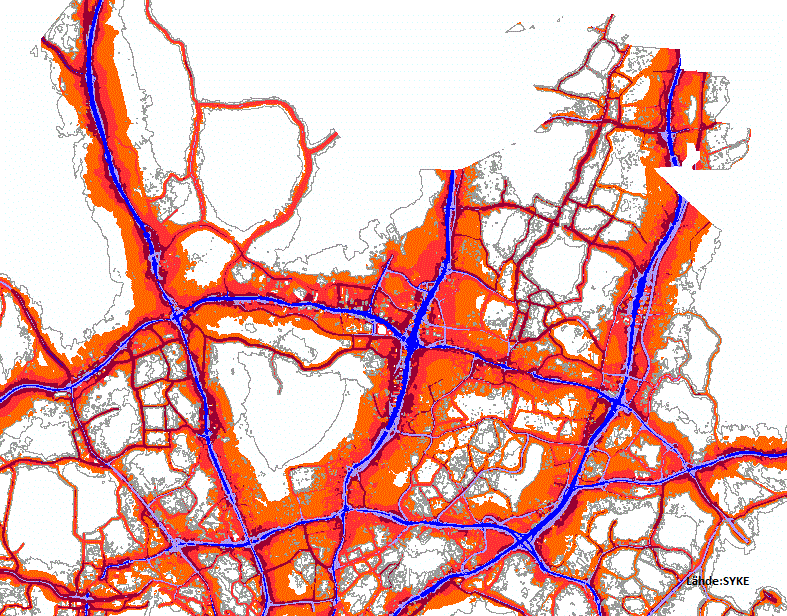
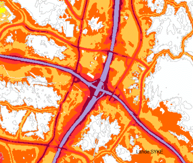
Vuoden 2017 EU:n ympäristömeludirektiivin mukaisen meluselvityksen melualueet on tuotettu yhdistämällä kuntien, Väyläviraston ja Finavian toimittamat aineistot EEA:n ohjeiden mukaisesti. Aineisto sisältää katujen ja teiden, maanteiden, raitioliikenteen ja lentokentän melulähteet ja meluvyöhykkeet. Aineistossa on pistemäistä, viivamaista ja aluemaista tietoa. Aineisto kuuluu SYKEn avoimiin aineistoihin (CC BY 4.0). Käyttötarkoitus: EU-raportointiin ja meluntorjunnan tueksi. Lisätietoja: https://geoportal.ymparisto.fi/meta/julkinen/Dokumentit/EUmeluselvitykset2017.pdf --- The Environmental noise maps dataset contains environmental noise maps from 2017 have been produced by combining the data provided by the municipalities, the Finnish Transport Agency and Finavia in accordance with EEA guidelines. The dataset includes noise sources and strategic noise maps for streets and roads, roads, railroads and airports. The data includes points, lines and polygons. Syke applies Creative Commons By 4.0 International license for open datasets.
-
Vuoden 2022 EU:n ympäristömeludirektiivin mukaisen meluselvityksen melualueet on tuotettu yhdistämällä kuntien, Väyläviraston ja Finavian toimittamat aineistot EEA:n ohjeiden mukaisesti. Lisätietoja (englanniksi) https://www.eionet.europa.eu/reportnet/docs/noise/guidelines/ Aineisto sisältää katujen ja teiden, maanteiden, rautateiden ja lentokentän melulähteet ja meluvyöhykkeet. Aineistossa on pistemäistä, viivamaista ja aluemaista tietoa. Aineisto kuuluu SYKEn avoimiin aineistoihin (CC BY 4.0). Aineistosta on julkaistu INSPIRE-tietotuote. Käyttötarkoitus: EU-raportointiin ja meluntorjunnan tueksi. --- The Environmental noise maps dataset contains environmental noise maps from 2022 have been produced by combining the data provided by the municipalities, the Finnish Transport Agency and Finavia in accordance with EEA guidelines, more information https://www.eionet.europa.eu/reportnet/docs/noise/guidelines/ The dataset includes noise sources and strategic noise maps for streets and roads, railways and airports. The data includes points, lines and polygons. Syke applies Creative Commons By 4.0 International license for open datasets. INSPIRE compatible dataset has been published.
-

Paikkatietohakemisto is a national metadata discovery service.