 Paikkatietohakemisto
Lithostratigraphy
Type of resources
Topics
Keywords
Provided by
Representation types
Update frequencies
status
Scale
-
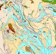
Bedrock of Finland 1:200 000 is a unified bedrock map dataset covering the whole Finland. It has been compiled by generalising the scale-free bedrock map feature dataset. The dataset consists of a lithological/stratigraphic geological unit polygon layer and linear layers, in which faults, diverse overprinting lines and dykes are represented. The dataset also includes an origin of the data and a quality estimation of the data polygon layers. The stratigraphic geological unit polygon layer includes lithological coding, geological time period and hierarchical lithostratigraphical or lithodemic classification as attributes in accordance with the Finnish database for stratigrafic geological units (Finstrati). The line layers have their own hierarchical classification. The data are at 1:200 000 scale, which indicates that the main part of the scale-free data have been generalised to correspond to a product at a scale of 1:200 000. Those areas where the source data is coarser than 1:200 000 have not been generalised. Coordinate reference system of the dataset was transformed in March 2013. The transformation from Finnish National Grid Coordinate System (Kartastokoordinaattijärjestelmä, KKJ) Uniform Coordinate Frame to ETRS-TM35FIN projection was done by using the three-dimensional transformation in accordance with the recommendations for the public administration JHS154.