 Paikkatietohakemisto
Tiff
Type of resources
Topics
Keywords
Contact for the resource
Provided by
Years
Formats
Representation types
Update frequencies
Scale
-
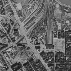
An aerial photograph is a photograph of the terrain taken from an aeroplane. The images are vertical photographs applicable to be used in mapping. The aerial photographs are reprocessed into dimensionally accurate images called orthophotos. Aerial photographs are available since the 1930s, depending on the area. Aerial photographs are available in black and white, colour and false colour. The size and accuracy of aerial photos depend on the camera, photography scale and altitude or ground sample distance (GSD). The product belongs to the open data of the National Land Survey of Finland. Aerial photographs can be ordered by pieces that cover a certain area. The latest orthophotos based on the aerial photographs can be downloaded free of charge from the File service of open data.
-
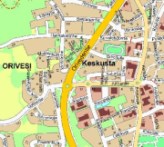
Opaskartta on yleistetty karttatuote, jonka ylläpitomittakaava on 1:10000. Opaskartat kattavat Oriveden kaupungin alueen: taajamasta on tarkempi karttatuote. Sisältää tiet (nimet ja osoitenumeroita), vesistöt, rakennetut alueet ja julkiset palvelut. Päivitetään harvoin.