 Paikkatietohakemisto
5000
Type of resources
Available actions
Topics
Keywords
Contact for the resource
Provided by
Years
Formats
Representation types
Update frequencies
status
Scale
Resolution
-
Agricultural parcel containing spatial data The agricultural parcels are a year-by-year data set containing the agricultural parcels in the annual aid application. A agricultural parcel is defined as a continuous area of a single reference parcel where a single crop, a mixture of crops or a mixture of crops is grown, set aside or used for a specific purpose. A reference parcel may have one or more agricultural parcels. A agricultural parcel may belong to only one reference parcel. The boundaries of the agricultural parcels, and hence their areas, may vary from year to year within the reference plot. The aim of the definition of valuable data sets (EU) 2023/138 has been to ensure that the most socially potential public data are reusable. The Food Authority is concerned with the theme Spatial data: reference parcels and agricultural parcels From the 2023 data onwards, the Food Authority will add attribute information to the published data as follows: Agricultural parcel containing spatial data - Organic production New field in the data set LUOMUVILJELY = Organic production: 1=absent or 0=no More information: https://www.ruokavirasto.fi/globalassets/tuet/maatalous/oppaat/hakuoppaat/peltotukiopas/peltotukien-hakuopas-2024.pdf
-
-
-

Grid net for statistics 5 km x 5 km covers whole of Finland. The grid net includes all grid cells in Finland. The location reference of a grid cell is the coordinates of the bottom left corner of each grid cell. An identifier in accordance with national conventions (consecutive numbering) has also been produced for each grid cell. The Grid net for statistics 5 km x 5 km is the area division used in the production of statistics by 5 km x 5 km grid cells. For utilizing grid data auxiliary table of regional classifications are available: https://www.stat.fi/org/avoindata/paikkatietoaineistot/tilastoruudukko_5km_en.html. The general Terms of Use must be observed when using the data: https://tilastokeskus.fi/org/lainsaadanto/copyright_en.html. In addition to the national version, an INSPIRE information product is also available from the data.
-
-
-
The EMODnet (European Marine Observation and Data network) Geology project collects and harmonizes marine geological data from the European sea areas to support decision making and sustainable marine spatial planning. The partnership includes 39 marine organizations from 30 countries. The partners, mainly from the marine departments of the geological surveys of Europe (through the Association of European Geological Surveys-EuroGeoSurveys), have assembled marine geological information at various scales from all European sea areas (e.g. the White Sea, Baltic Sea, Barents Sea, the Iberian Coast, and the Mediterranean Sea within EU waters). This multiscale dataset includes EMODnet seabed substrate maps at a scale of 1:1 500, 1:5 000, 1:10 000, 1:15 000, 1:20 000, 1:25 000, 1:30 000, 1:45 000, 1: 50 000, 1:60 000, 1:70 000 from the European marine areas. Traditionally, European countries have conducted their marine geological surveys according to their own national standards and classified substrates on the grounds of their national classification schemes. These national classifications are harmonised into a shared EMODnet schema using Folk's sediment triangle with a hierarchy of 16, 7 and 5 substrate classes. The data describes the seabed substrate from the uppermost 30 cm of the sediment column. Further information about the EMODnet Geology project is available on the portal (http://www.emodnet-geology.eu/).
-
Harvester Seasons is a service designed to help with estimating evolving trafficability conditions in forested terrain based on weather and model forecast information. The full service is currently provided for the geographical area of Finland.
-
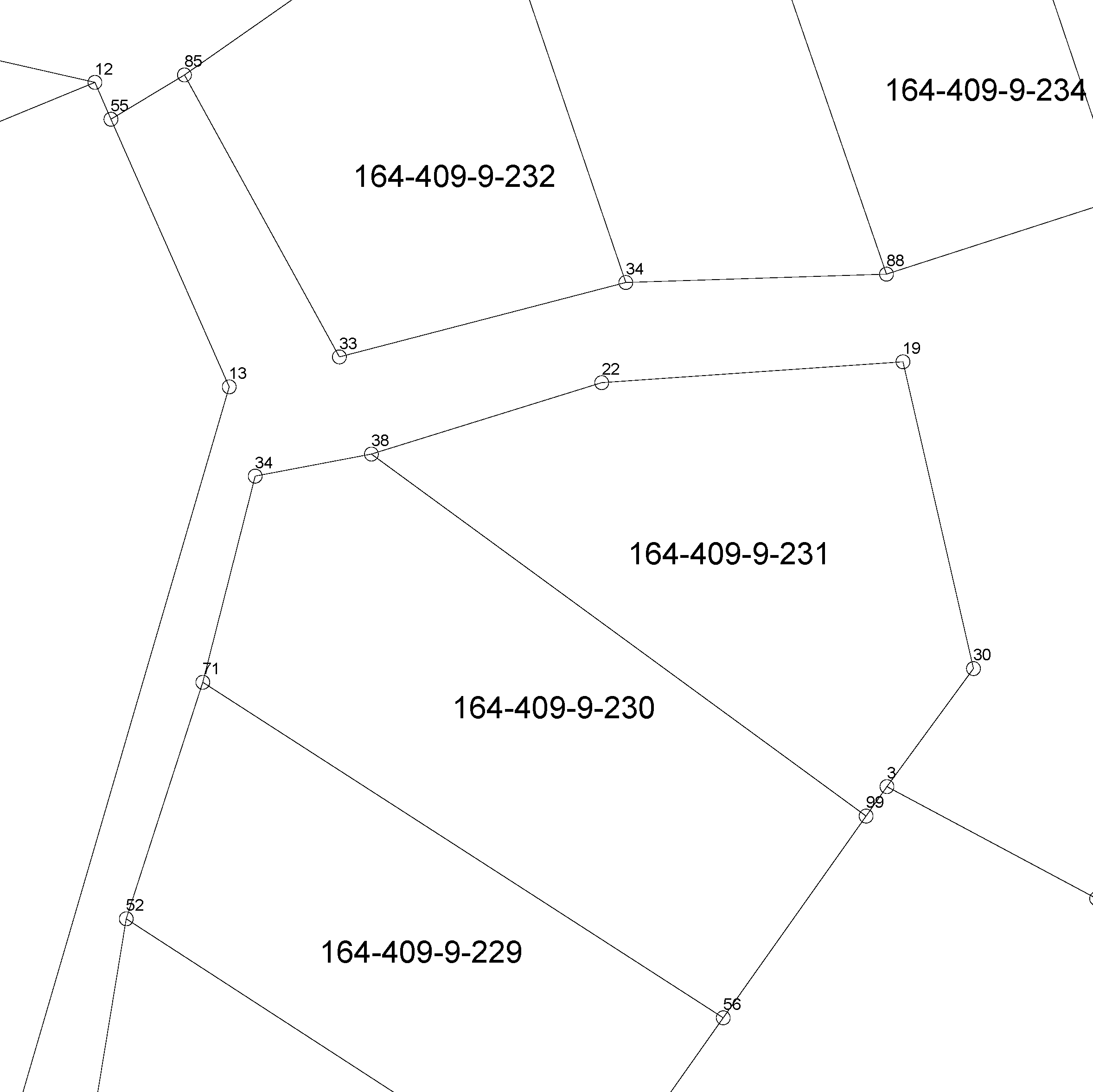
The location of the real property unit is shown on the cadastral index map. On the map, there are property and other register unit boundaries and property identifiers. The product is a part of the open data of the National Land Survey. Further information (in Finnish): http://www.maanmittauslaitos.fi/kiinteistot/asiantuntevalle-kayttajalle/kiinteistotiedot-ja-niiden-hankinta
-