 Paikkatietohakemisto
2017
Type of resources
Available actions
Topics
Keywords
Contact for the resource
Provided by
Years
Formats
Representation types
Update frequencies
Service types
Scale
Resolution
-
The Arctic SDI Gazetteer Service is a service that contains authoritative place names data from the arctic area. The service can be used for searching place names and performing reverse geocoding. The service contains about 2.87 million place name locations with about 3.15 million place names. It contains data from following sources: * Canada (Natural Resources Canada, updated: 02/2018) * Denmark (including Greenland) (SDFE, updated: 05/2017) * Finland (National Land Survey of Finland, updated: 04/2017) * GEBCO Undersea feature names gazetteer (updated: 04/2019) * Iceland (National Land Survey of Iceland, updated: 08/2017) * Norway (Norwegian Mapping Authority, updated: 08/2017) * Russia (Russian Mapping Agency, updated: 04/2019) * Sweden (Swedish National Mapping Agency, updated: 05/2017) * USA (US Geological Survey, updated: 05/2017)
-
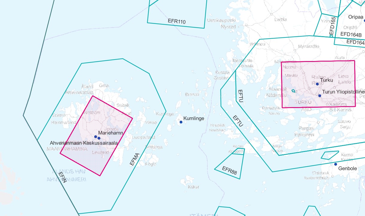
Air traffic network-product is a link-knot routing dataset compliant with INSPIRE requirements. It includes f.ex. flight routes and aerodromes. Data shall not be used for operational flight activities or flight planning. INSPIRE Air Traffic Network-product includes spatial information of air traffic network in accordance with the INSPIRE Directive. The data has been retrieved from the EAD database maintained by Eurocontrol. Information is updated regularly but is not constantly up to date. Data can be used for purposes that are in accordance with the INSPIRE Directive, but shall not be used for operational flight activities or flight planning. ANS Finland www.ais.fi –site provides information for operational flight activities or flight planning Available layers Aerodrome Node: Node located at the aerodrome reference point of an airport/heliport, which is used to represent it in a simplified way.DEFINITION Aerodrome Reference Point (ARP): The designated geographical location of an aerodrome, located near the initial or planned geometric centre of the aerodrome and normally remaining where originally established [AIXM3.3].DEFINITION Airport/heliport: A defined area on land or water (including any buildings, installations and equipment) intended to be used either wholly or in part for the arrival, departure and surface movement of aircraft/helicopters [AIXM5.0]. Air Route Link: A portion of a route to be flown usually without an intermediate stop, as defined by two consecutive significant points Air Space Area: A defined volume in the air, described as horizontal projection with vertical limits. Designated Point: A geographical location not marked by the site of a radio navigation aid, used in defining an ATS route, the flight path of an aircraft or for other navigation or ATS purposes. Instrument Approach Procedure: A series of predetermined manoeuvres by reference to flight instruments with specified protection from obstacles from the initial approach fix, or where applicable, from the beginning of a defined arrival route to a point from which a landing can be completed and thereafter, if a landing is not completed, to a position at which holding or en route obstacle clearance criteria apply. Navaid: One or more Navaid Equipments providing navigation services.DEFINITION Navaid equipment: A physical navaid equipment like VOR, DME, localizer, TACAN or etc. Procedure Link: A series of predetermined manoeuvres with specified protection from obstacles. Runway Area: A defined rectangular area on a land aerodrome/heliport prepared for the landing and take-off of aircraft. Runway Centerline Point: An operationally significant position on the center line of a runway direction. Standard Instrument Arrival: A designated instrument flight rule (IFR) arrival route linking a significant point, normally on an ATS route, with a point from which a published instrument approach procedure can be commenced. Standard Instrument Departure: A designated instrument flight rule (IFR) departure route linking the aerodrome or a specific runway of the aerodrome with a specified significant point, normally on a designated ATS route, at which the en-route phase of a flight commences. Surface Composition: Runway surface material CTR (Not INSPIRE): A control zone (CTR) is a block of Controlled Airspace extending from the surface of the earth to a specified upper limit.
-
Virtain kaupungin (Virrat) ajantasa-asemakaava on koostekartta hyväksytyistä ja lainvoiman saaneista asemakaavoista. Aineisto on tuotettu lainvoimaisten asemakaavojen pohjalta. Kartalta voi myös ladata asemakaavojen PDF-muotoiset kaavadokumentit. Asiasanat: Virrat Virtain Asemakaava
-
Harjavallan kaupungin Karttapalvelu on WMS-rajapintapalvelu, jonka kautta on katseltavissa seuraavat karttatasot: Vesihuollon toiminta-alueet, Yleiskaavayhdistelmä, Asemakaavayhdistelmä, Pohjakartta, Virastokartta, Osoitekartta. Palvelu perustuu Harjavallan kaupungin hallinnoimiin aineistoihin. Palvelun käyttö on maksutonta ja ei vaadi autentikointia eli tunnistautumista käyttäjätunnuksen ja salasanan avulla.
-
Tiedot 140 yhdistysten ylläpitämästä kiinteistöstä Varsinais-Suomen kylissä, maaseudulla ja saaristossa. Kentät: - Kohteen nimi - Omistaja - Kuvaus - Osoite - Kunta - Lisätiedot
-
Iisalmen ajantasa-asemakaava on koostekartta hyväksytyistä ja lainvoiman saaneista asemakaavoista. Aineisto on tuotettu lainvoimaisten asemakaavojen pohjalta ja sitä ylläpidetään Oracle- tietokannassa Trimble Locus- järjestelmässä. Kuvaustekniikan mittakaava 1:1000. Päivitys ja ylläpito jatkuvaa.
-
Iisalmen kiinteistörekisterikartta sisältää valtakunnallisen kiinteistörekisterin mukaiset kiinteistörajat ja kiinteistötunnukset. Aineistoa ylläpitää Iisalmen kaupungin tonttipalvelut ja maanmittauslaitos.
-
Ympäristönsuojelulaissa (527/2014, YSL) määritellään siirtymäaika viemäriverkostojen ulkopuolisten ennen vuotta 2004 voimassa olleisiin rakentamisajankohdan mukaisiin vaatimuksiin tai myönnettyyn rakennuslupaan perustuvien jätevedenkäsittelyjärjestelmien tehostamiselle. Siirtymäaika 31.10.2019 koskee käsittelyjärjestelmiä, joihin muodostuu talousjätevettä rakennuksesta, joka sijaitsee enintään 100 metrin päässä vesistön tai meren keskiveden mukaisesta rantaviivasta. Etäisyys mitataan siitä rakennuksen seinästä, joka on lähinnä rantaviivaa. Siirtymäaika koskee myös jätevesien käsittelyjärjestelmiä, jotka ovat 1- tai 2-luokan pohjavesialueilla. Tämä paikkatietoaineisto antaa suuntaa antavan kuvauksen ympäristönsuojelulain tarkoittamasta etäisyydestä, mutta yksittäistapauksissa tapauskohtainen tarkastelu tulee tehdä maastossa. Aineistossa on kaksi karttatasoa: Ensimmäinen karttataso kuvaa vesistöistä 100 metrin etäisyyteen ulottuvaa vyöhykettä. Toinen karttataso kuvaa vesistöistä 90 – 110 metrin päässä olevaa varovyöhykettä, jonka tarkoitus on kuvata aineistoon liittyvää epävarmuutta. Karttatasot on muodostettu puskuroimalla Maanmittauslaitoksen maastotietokannan (2017) aluemaisia jokia, merta ja järviä (>= 1 ha) sekä SYKEn Vipu-uomia, jotka perustuvat maastotietokantaan vuosilta 2000-2008. Paikkatietoaineiston käyttö rakennuksen etäisyyteen rannasta antaa viitteellisen tuloksen ja siihen liittyy merkittävää paikallista epävarmuutta: Aukotonta aineistoa vesistöistä ei ole olemassa. Aineistossa saattaa olla mukana vesialueita, jotka eivät ole vesilain mukaisia vesistöjä ja toisaalta aineistosta saattaa puuttua vesistöjä. Etenkin pienet vesistöt, kuten purot joiden valuma-alue on alle 10 km2 ja alle 1 ha kokoiset lammet jäävät aineistosta pois. Ympäristönsuojelulain mukaan etäisyys vesistöön määritellään keskivedenkorkeuden mukaisesta rantaviivasta. Tätä tietoa ei ole käytettävissä paikkatietoaineistossa. Keskivedenkorkeus on systemaattiseen vedenkorkeuden seurantaan perustuva vedenpinnankorkeuksien päivähavaintojen keskiarvo. Paikkatietoaineistossa oleva rantaviiva perustuu pitkäaikaiseen keskiveden korkeuteen perustuvaan havainnointiin ja se voi poiketa merkittävästi keskivedenkorkeuden mukaisesta rantaviivasta. Käyttäjän pitää osata tulkita mikä on vesistöä lähinnä oleva seinä tai onko paikkatietoaineiston vesialue vesistö vai ei. Aineisto kuuluu SYKEn avoimiin aineistoihin (CC BY 4.0). Käyttötarkoitus: Aineisto on kuntien viranomaisten apuna aluemäärittelyn tekemisessä, sekä muiden tiedontarvitsijoiden käytettävissä. Vyöhykeaineisto antaa suuntaa antavan kuvauksen ympäristönsuojelulain tarkoittamasta etäisyydestä, mutta yksittäistapauksissa tapauskohtainen tarkastelu tulee tehdä maastossa. Lisätietoja: http://www.ymparisto.fi/fi-FI/Rakentaminen/Rakennushanke/Talotekniset_jarjestelmat_LVI/Kiinteiston_jatevesien_kasittely/Syventavaa_tietoa/Hajajatevesien_YSLn_mukaiset_siirtymaaikaalueet *** The Environmental Protection Act (527/2014) defines the required treatment efficiency for on-site wastewater treatment. Treatment requirements automatically apply to all new constructions. Old buildings, permanently habited houses, summerhouses, farmhouses etc. have a two-phase transition period. Buildings situated, either on a) a groundwater area, or b) closer than 100 meters from the mean water level of a water body, defined by The Water Act, need to fulfill the treatment requirements, by 31. October 2019. The other buildings do not have a transition period bound to a date. This data provides approximate spatial information about the coastal areas defined in the Environmental Protection Act. There are two map layers: one with a 100-meter distance from a water body, and the other with a 90–110 meter zone from a water body. The uncertainty of the data must be taken into account. The data is not to be understood as an amendment to the Environmental Protection Act. This SYKE’s dataset can be used according to open data license (CC BY 4.0).
-
Museoviraston INSPIRE katselupalvelu on WMS-rajapintapalvelu, jonka kautta on saatavilla seuraavat karttatasot (suluissa tekninen nimi): Kiinteiden muinaisjäännösten pistemäinen sijainti/ Protected Sites - Archeaological (PS.ProtectedSitesArchaeologicalPoint), Kiinteiden muinaisjäännösten aluemainen sijainti/ Protected Sites - Archeaological (PS.ProtectedSitesArchaeologicalPolygon), Aluerajauksina merkityt valtakunnallisesti merkittävät rakennetut kulttuuriympäristöt, RKY/ Protected Sites - Landscape (PS.ProtectedSitesLandscapePolygon) Pistemäisinä merkityt valtakunnallisesti merkittävät rakennetut kulttuuriympäristöt, RKY/ Protected Sites - Landscape (PS.ProtectedSitesLandscapePoint) Viivamaisina merkityt valtakunnallisesti merkittävät rakennetut kulttuuriympäristöt, RKY/ Protected Sites - Landscape (PS.ProtectedSitesLandscapeLine) Palvelu perustuu suojeltujen, rauhoitettujen ja valtakunnallisesti merkittävien kulttuuriympäristökohteiden tietoja sisältäviin muinaisjäännösrekisteriin ja RKY-inventointiin. Aineistoja hallinnoi Museovirasto. Palvelun käyttö on maksutonta eikä vaadi autentikointia eli tunnistautumista käyttäjätunnuksen ja salasanan avulla.
-
The technical harvesting potential of small-diameter trees can be defined as the maximum potential procurement volume of small-diameter trees available from the Finnish forests based on the prevailing guidelines for harvesting of energy wood. The potentials of small-diameter trees from early thinnings have been calculated for fifteen NUTS3-based Finnish regions covering the whole country (Koljonen et al. 2017). To begin with the estimation of the region-level potentials, technical harvesting potentials were estimated using the sample plots of the eleventh national forest inventory (NFI11) measured in the years 2009–2013. First, a large number of sound and sustainable management schedules for five consecutive ten-year periods were simulated for each sample plot using a large-scale Finnish forest planning system known as MELA (Siitonen et al. 1996; Redsven et al. 2013). MELA simulations consisted of natural processes and human actions. The ingrowth, growth, and mortality of trees were predicted based on a set of distance-independent tree-level statistical models (e.g. Hynynen et al. 2002) included in MELA and the simulation of the stand (sample plot)-level management actions was based on the current Finnish silvicultural guidelines (Äijälä et al. 2014) and the guidelines for harvesting of energy wood (Koistinen et al. 2016). Simulated management actions for the small-tree fraction consisted of thinnings that fulfilled the following stand criteria: • mean diameter at breast height ≥ 8 cm • number of stems ≥ 1500 ha-1 • mean height < 10.5 m (in Lapland) or mean height < 12.5 m (elsewhere). Energy wood was harvested as delimbed (i.e. including the stem only) in spruce-dominated stands and peatlands and as whole trees (i.e. including stem and branches) elsewhere. When harvested as whole trees, a total of 30% of the original crown biomass was left onsite (Koistinen et al. 2016). Energy wood thinnings could be integrated with roundwood logging or carried out independently. Second, the technical energy wood potential of small trees was operationalized in MELA by maximizing the removal of thinnings in the first period. In this way, it was possible to pick out all small tree fellings simulated in the first period despite, for example, the profitability of the operation. However, a single logging event was rejected if the energy wood removal was lower than 25 m³ha-1 or the industrial roundwood removal of pine, spruce, or birch exceeded 45 m³ha-1. The potential calculated in this way contained also timber suitable for industrial roundwood. Therefore, two estimates are given: • potential of trees below 10.5 cm in breast-height diameter • potential of trees below 14.5 cm in breast-height diameter. Subsequently, the region-level potentials were spread on a raster grid at 1 km × 1 km resolution. Only grid cells on Forests Available for Wood Supply (FAWS) were considered in this operation. In this study, FAWS was defined as follows: First, forest land was extracted from the Finnish Multi-Source National Forest Inventory (MS-NFI) 2013 data (Mäkisara et al. 2016). Second, restricted areas were excluded from forest land. The restricted areas consisted of nationally protected areas (e.g. nature parks, national parks, protection programme areas) and areas protected by the State Forest Enterprise. In addition, some areas in northernmost Lapland restricted by separate agreements between the State Forest Enterprise and stakeholders were left out from the final data. Furthermore, for small trees, FAWS was further constrained by the stand criteria presented above to represent similar stand conditions for small-tree harvesting as in MELA. Finally, the region-level potentials were distributed to the grid cells by weighting with MS-NFI stem wood biomasses. References Äijälä O, Koistinen A, Sved J, Vanhatalo K, Väisänen P (2014) Metsänhoidon suositukset [Guidelines for sustainable forest management]. Metsätalouden kehittämiskeskus Tapion julkaisuja. Hynynen J, Ojansuu R, Hökkä H, Salminen H, Siipilehto J, Haapala P (2002) Models for predicting the stand development – description of biological processes in MELA system. The Finnish Forest Research Institute Research Papers 835. Koistinen A, Luiro J, Vanhatalo K (2016) Metsänhoidon suositukset energiapuun korjuuseen, työopas [Guidelines for sustainable harvesting of energy wood]. Metsäkustannus Oy, Helsinki. Koljonen T, Soimakallio S, Asikainen A, Lanki T, Anttila P, Hildén M, Honkatukia J, Karvosenoja N, Lehtilä A, Lehtonen H, Lindroos TJ, Regina K, Salminen O, Savolahti M, Siljander R (2017) Energia ja ilmastostrategian vaikutusarviot: Yhteenvetoraportti. [Impact assessments of the Energy and Climate strategy: The summary report.] Publications of the Government´s analysis, assessment and research activities 21/2017. Mäkisara K, Katila M, Peräsaari J, Tomppo E (2016) The Multi-Source National Forest Inventory of Finland – methods and results 2013. Natural resources and bioeconomy studies 10/2016. Redsven V, Hirvelä H, Härkönen K, Salminen O, Siitonen M (2013) MELA2012 Reference Manual. Finnish Forest Research Institute. Siitonen M, Härkönen K, Hirvelä H, Jämsä J, Kilpeläinen H, Salminen O, Teuri M (1996) MELA Handbook. Metsäntutkimuslaitoksen tiedonantoja 622. ISBN 951-40-1543-6.