 Paikkatietohakemisto
Suuralueellinen geokemia; purosedimentti
Geochemical atlas of Finland: stream sediment
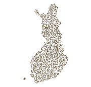
Suuralueellinen purosedimenttigeokemiallinen kartoitusaineisto kuvaa pienten latvapurojen orgaanisen purosedimentin alkuaineiden pitoisuuksia. Näytteet on otettu pienistä latvapuroista (valuma-alue alle 30 km2) loppukesällä 1990. Näytteenotto on toistettu noin joka neljännessä pisteessä vuosina 1995, 2000 ja 2006. Näytemäärät olivat vuonna 1990 1162 (tiheys 1 näyte/300 km2), vuonna 1995 286, vuonna 2000 286 ja vuonna 2006 249 kappaletta. Aineisto kattaa koko Suomen. Samaan aikaan on otettu myös purovesinäytteitä.
Näytteiden otto, käsittely ja analytiikka on kuvattu Suomen geokemian atlaksen 3. osan (Lahermo ym. 1996) sivuilla 27-30. Kenttähavainnot, koordinaatit ja näytteestä määritetyt alkuainepitoisuudet on yhdistetty tietokannaksi, jonka kukin tietue kuvaa yhtä näytepistettä. Kunkin näytteenottovuoden tiedot on talletettu eri tauluihin. Analyysimenetelmään viitataan nelimerkkisellä menetelmäkoodilla. Koodit ovat seuraavat:
503H = elohopeamääritys kylmähöyrymenetelmällä
503P = uutto typpihappouutolla mikroaaltouunissa, mittaus ICP-AES:llä
503M = uutto typpihappouutolla mikroaaltouunissa, mittaus ICP-MS:llä
820L = hiili, vety ja typpi LECO-analysaattorilla
Alkuainepitoisuus-tietoon kuuluu numeerinen pitoisuusarvo yksikössä mg/kg (eli ppm) ja mahdollinen tarkistusmerkki. Pitoisuus on talletettu muuttujaan, jonka nimi koostuu alkuaineen kemiallisesta merkistä ja analyysimenetelmän koodista. Esimerkiksi AS_503M on arseenin (As) pitoisuus, joka on määritetty ICP-MS-menetelmällä (503M). Sitä seuraava muuttuja on tarkistusmerkki, esimerkiksi AS_503MT. Jos lukuarvoa seuraava tarkistusmerkki on ’>’ tai ’<’, niin pitoisuuskenttään talletettu lukuarvo on kemiallisen analyysimenetelmän määritysraja ja todellinen pitoisuus on tätä arvoa pienempi. Jos tarkistusmerkki on huutomerkki (!), analyysitulos on pienempi kuin analyysimenetelmän määritysraja, mutta tietokantaan on talletettu mittauslaitteen (epäluotettava) mittaustulos. Jos tarkistusmerkki on ’x’, tieto puuttuu.
Suuralueellisen purosedimenttigeokemiallisen kartoitusaineiston alkuperäinen käyttötarkoitus oli valtakunnallinen geokemiallinen yleiskartoitus ja ympäristön tilan perusarviointi. Muita käyttötapoja ovat esimerkiksi ympäristön tilan muutosten arviointi ja purosedimenttien taustapitoisuuksien määrittäminen.
The Regional Stream Sediment Geochemical Mapping data set gives information on the elemental concentrations in organic sediments of small headwater streams. The samples have been taken from small headwater streams (catchment area under 30 km2) in the late summer of 1990. Sampling has been repeated for about every fourth point during the years 1995, 2000 and 2006. The number of samples was 1162 in 1990 (at a density of one sample / 300 km2), 286 in 1995, 286 in 2000 and 249 in 2006. The data set covers the whole of Finland. Stream water samples have also been taken at the same time.
Sampling, processing and analysis methods have been described in the Geochemical Atlas of Finland, Part 3, p. 27 - 30 (Lahermo et. al 1996). Field observations, coordinates and element concentrations determined from samples have been made into a database, in which each record represents one sample point. The data for each sampling year have been recorded on different tables. The method of analysis is referred to with a four-character method code. The codes are as follows:
503H = mercury determination using the cold vapour method
503P = nitric acid extraction in a microwave oven, measurement with ICP-AES
503M = nitric acid extraction in a microwave oven, measurement with ICP-MS
820L = carbon, hydrogen and nitrogen determination with a LECO analyser.
The element concentration data include a numerical concentration value (as mg kg-1 or ppm) and possibly a check mark. The concentration is recorded as a variable, which has a name that comprises the chemical symbol for the element and the code for the method of analysis. For example AS_503M is arsenic (As) concentration, which is determined with the ICP-MS method (503M). The next variable has a check mark, for example AS_503MT. If the numerical value following the check mark is ‘>’ or '‘<’ then the number recorded in the concentration field is the determination limit of the chemical analytical method used and the actual concentration is less than this value. If the check mark is an exclamation mark (!), the analytical result is smaller than the determination limit of the analytical method use but the (unreliable) value obtained with the measuring instrument has been entered in the database. There is no data are if the check mark is a 'x'.
The original purpose of the Regional Stream Water Geochemical Mapping data set was national general geochemical mapping and the basic assessment of environmental state. Other uses are, for example, the assessment of changes in environmental state and determination of the baseline concentrations of surface water as part of the evaluation of the chemical state of catchment areas in accordance with the Water Framework Directive of the EU. The original purpose of the Regional Stream Water Geochemical Mapping data set was national general geochemical mapping and the basic assessment of environmental state. Other uses are, for example, the assessment of changes in environmental state and determination of the baseline concentrations of surface water as part of the evaluation of the chemical state of catchment areas in accordance with the Water Framework Directive of the EU.
Simple
-
Date (Publication)Date (Julkaisu)
- 2010-11-22
- Unique resource identifier
- http://paikkatiedot.fi/so/1000169
-
KäyttötarkoitusPurpose
-
Suuralueellisen purosedimenttigeokemiallisen kartoitusaineiston alkuperäinen käyttötarkoitus oli valtakunnallinen geokemiallinen yleiskartoitus ja ympäristön tilan perusarviointi. Muita käyttötapoja ovat esimerkiksi ympäristön tilan muutosten arviointi ja purosedimenttien taustapitoisuuksien määrittäminen.
The original purpose of the Regional Stream Sediment Geochemical Mapping data set was national general geochemical mapping and the basic assessment of environmental state. Other uses are, for example, the assessment of changes in environmental state and determination of the baseline concentrations of stream sediments.
-
Geosanasto
Geosanasto
-
-
Geokemia
Geochemistry
-
Purosedimentti
Stream sediments
-
Kartoitus
Mapping
-
Näytteenotto
Sampling
-
Kemialliset analyysit
Chemical analysis
-
Geokemialliset tutkimukset
Geochemical surveys
-
Geokemialliset provinssit
Geochemical provinces
-
Alkuaineet
Chemical elements
-
-
PlacePaikka
-
-
Suomi
Finland
-
-
DisciplineToimiala
-
-
Geokemialliset kartat
Geochemical maps
-
Kartastot
Atlas
-
Geokemia
Geochemistry
-
Purosedimentti
Stream sediments
-
Kartoitus
Mapping
-
Näytteenotto
Sampling
-
Kemialliset analyysit
Chemical analysis
-
-
TemporalAikajakso
-
-
1990-2006
1990-2006
-
-
GEMET - INSPIRE themes, version 1.0
-
-
Geologia
Geology
-
-
Paikkatietohakemiston asiasanasto
-
-
Ei-Inspire
Not-Inspire
-
-
Access constraintsSaantirajoitteet
-
Other restrictionsMuut rajoitteet
-
Muut rajoitteetOther constraints
-
julkista saatavuutta ei ole rajoitettuno limitations to public access
-
Use constraintsKäyttörajoitteet
-
Other restrictionsMuut rajoitteet
-
Muut rajoitteetOther constraints
-
Geologian tutkimuskeskuksen peruslisenssiGeological Survey of Finland's basic licence
-
Spatial representation typeSijaintitiedon esitystapa
-
VectorVektori
-
Metadata languageMetatiedon kieli
- Finnish
-
Topic categoryAiheluokka
-
-
Geoscientific informationGeotieteet
-
))
-
Unique resource identifier
-
EPSG:3067
-
Topology levelTopologian taso
-
Geometry onlyPelkkä geometria
-
Distribution formatJakeluformaatti
-
-
ESRI file gdbESRI file gdb
(
10.1
)
-
ESRI file gdbESRI file gdb
(
10.1
)
-
OnLine resourceOnline-lähteen tiedot
- http://gtkdata.gtk.fi/mdae/index.html ( WWW:LINK-1.0-http--link )
-
Hierarchy levelRaportoinnin laajuuden hierarkiataso
-
DatasetTietoaineisto
Conformance result
Vaatimuksenmukaisuus
-
Date (Publication)Date (Julkaisu)
- 2010-12-08
-
Selitys
-
Aineisto ei ole INSPIRE-tietotuotemäärittelyn mukainen
-
PassSääntöjenmukaisuusaste
- No
-
Kuvaus aineiston historiastaStatement
-
Näytteen koordinaatit on määritetty 1:20 000 -peruskarttalehdiltä tai pienempimittakaavaisilta kartoilta. Kentällä on havainnoitu puron leveys, veden virtausnopeus, ympäristön maankäyttö ja maalaji näytteenottopisteessä. Muut tiedot perustuvat laboratoriossa tehtyihin kemiallisiin analyyseihin.
Kenttähavainnot on koodattu seuraavasti:
Aines
MU muta
LJ lieju
X tieto puuttuu
Virran (puron) leveys ilmoitetaan metreinä.
Virtausnopeus on arvioitu neliluokkaisella asteikolla:
1 seisova vesi
2 selvä virtaus
3 nopea virtaus
4 uoma kuivillaan
Ympäristön maankäyttö on koodattu seuraavasti:
H hakkuuaukea
M metsä, pensaikko
N niitty, viljelemätön pelto
P viljelty pelto
S suo
T taaja asutus
X tuntematon
Maaperä
HK hiekka
KA kallio, louhikko, kivikko
MR moreeni
SA savi, siltti
TU turve
XX tuntematon
Kansantl
X Näytteestä on tehty lisämäärityksiä Kansanterveyslaitoksella (mykobakteerit).
Suuralueellisessa purosedimenttigeokemiallisessa kartoituksessa näytteet kerättiin 0,06 mm silmäkoon seulakangashaavilla usean kymmenen metrin matkalta. Näytekoko oli noin 0,5 l. Karkein mineraaliaines poistettiin dekantoimalla ja karkea orgaaninen aines poistettiin seulomalla noin 2 mm muoviseulalla. Näytteet kuivattiin 60oC:n lämpötilassa ja hienonnettiin muoviteräisellä leikkurilla. Lopuksi näytteet seulottiin <2 mm raekokoon ennen kemiallisia analyysejä. Yksityiskohtaiset näytteenottokuvaukset on esitetty julkaisussa Lahermo ym. (1996) ja vuoden 2000 osalta Gregorauskiene ym. (2000).
Näytteet analysoitiin Geologian tutkimuskeskuksen (GTK) laboratoriossa Otaniemessä. Laboratorio on akkreditoidu TO25 (EN ISO/IEC 17025) mukaisesti.
Näytteet liuotettiin väkevällä typpihapolla mikroaaltouunissa (US EPA 3051A) ja analysoitiin induktiivisesti kytketyllä plasma massaspektometrillä (ICP-MS) ja plasma atomiemissiospektrometrillä (ICP-AES). Elohopea määritettiin kylmähöyrymenetelmällä. Hiili, vety ja typpi määritettiin LECO-analysaattorilla.
The coordinates of the samples have been determined from 1:20 000 base maps or from smaller scale maps. Stream width, the flow rate, surrounding land-use and the sediment type at the sample site have been observed in the field. Other data are based on chemical analyses done in the laboratory.
Field observations are coded as follows:
Material
MU mud
LJ gyttja
X no data
Width of flow (stream) is given in metres.
The flow rate is estimated using a four degree scale:
1 standing water
2 clear flow
3 rapid flow
4 dry river bed
Surrounding land-use is coded as follows:
H clear cut area
M forest, bush
N meadow, uncultivated field
P cultivated field
S mire
T dense habitation
X unknown
Sediment/terrain type
HK sand
KA rock, boulder field, rock field
MR till
SA clay, silt
TU peat
XX unknown
Kansantl
X Additional determinations (mycobacteria) have been analysed from the sample at the National Institute for Health and Welfare (THL).
In Regional Stream Sediment Geochemical Mapping samples were collected using a (nylon) sieve cloth frame with a 0.06 mm mesh size over a distance on several dozen metres. The sample size was ca. 0.5 l. The coarsest mineral matter was removed by decanting and coarse organic matter was removed by sifting with a plastic sieve (ca. 2 mm mesh size). The samples were dried at a temperature of 60°C and ground fine with a plastic-bladed cutter. Finally, the samples were sieved to less than two mm grain size prior to chemical analysis. Detailed sampling descriptions are given in Lahermo et al. (1996) and for the year 2000 by Gregorauskiene et al. (2000).
The samples were analysed in the laboratory of Geological Survey of Finland (GTK) in Otaniemi. The laboratory is accredited in accordance with TO25 (EN ISO/IEC 17025).
The samples were dissolved in concentrated nitric acid in a microwave oven (US EPA 3051A) and analysed with an inductively coupled plasma mass spectrometer (ICP-MS) and with a plasma atomic emission spectrometer (ICP-AES). Mercury was determined with a cold vapour method. Carbon, hydrogen and nitrogen were determined using a LECO analyser.
-
DescriptionDescription
-
Suuralueellisessa purosedimenttigeokemiallisessa kartoituksessa näytteet kerättiin 0,06 mm silmäkoon seulakangashaavilla usean kymmenen metrin matkalta. Näytekoko oli noin 0,5 l. Karkein mineraaliaines poistettiin dekantoimalla ja karkea orgaaninen aines poistettiin seulomalla noin 2 mm muoviseulalla. Näytteet kuivattiin 60oC:n lämpötilassa ja hienonnettiin muoviteräisellä leikkurilla. Lopuksi näytteet seulottiin <2 mm raekokoon ennen kemiallisia analyysejä. Yksityiskohtaiset näytteenottokuvaukset on esitetty julkaisussa Lahermo ym. (1996) ja vuoden 2000 osalta Gregorauskiene ym. (2000).
Näytteet analysoitiin Geologian tutkimuskeskuksen (GTK) laboratoriossa Otaniemessä. Laboratorio on akkreditoidu TO25 (EN ISO/IEC 17025) mukaisesti.
Näytteet liuotettiin väkevällä typpihapolla mikroaaltouunissa (US EPA 3051A) ja analysoitiin induktiivisesti kytketyllä plasma massaspektometrillä (ICP-MS) ja plasma atomiemissiospektrometrillä (ICP-AES). Elohopea määritettiin kylmähöyrymenetelmällä. Hiili, vety ja typpi määritettiin LECO-analysaattorilla.
Näytteet analysoitiin Geologian tutkimuskeskuksen (GTK) laboratoriossa Otaniemessä. Kenttätiedot on yhdistetty analyysituloksiin SPSS-ohjelmalla kenttätunnuksen perusteella.
In Regional Stream Sediment Geochemical Mapping samples were collected using a (nylon) sieve cloth frame with a 0.06 mm mesh size over a distance on several dozen metres. The sample size was ca. 0.5 l. The coarsest mineral matter was removed by decanting and coarse organic matter was removed by sifting with a plastic sieve (ca. 2 mm mesh size). The samples were dried at a temperature of 60°C and ground fine with a plastic-bladed cutter. Finally, the samples were sieved to less than two mm grain size prior to chemical analysis. Detailed sampling descriptions are given in Lahermo et al. (1996) and for the year 2000 by Gregorauskiene et al. (2000).
The samples were analysed in the laboratory of Geological Survey of Finland (GTK) in Otaniemi. The laboratory is accredited in accordance with TO25 (EN ISO/IEC 17025).
The samples were dissolved in concentrated nitric acid in a microwave oven (US EPA 3051A) and analysed with an inductively coupled plasma mass spectrometer (ICP-MS) and with a plasma atomic emission spectrometer (ICP-AES). Mercury was determined with a cold vapour method. Carbon, hydrogen and nitrogen were determined using a LECO analyser.
The samples were analysed in the laboratory of Geological Survey of Finland (GTK) in Otaniemi.
The field data have been combined with analytical results via a field code by using the SPSS program.
-
File identifierTiedostotunniste
- 463f5375-0fae-4dc5-af90-a8ebbf87035a XML
-
Metadata languageMetatiedon kieli
- Finnish
-
Hierarchy levelResurssin tyyppi
-
SeriesTietoaineistosarja
- Hierarchy level name
-
Aineisto
-
Date stampMetatiedon päiväys
- 2024-02-21T09:32:07
Overviews
Spatial extent
Provided by
