 Paikkatietohakemisto
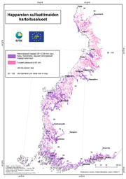
Acid sulfate soils 1:250 000
The data on acid sulfate soils in 1:250 000 scale contains material generated since 2009 on the existence and properties of sulfate soils on the Finnish coastal areas and their drainage basins roughly up to the highest shoreline of the ancient Litorina Sea. The data contains the following levels:
- Acid sulfate soils, 1:250 000 maps
o Probability of the existence of acid sulfate soils
o Probability of the existence of coarse-grained acid sulfate soils
- Acid sulfate soils, profile points on 1:250 000 maps
- Acid sulfate soils, survey points on 1:250 000 maps
- Acid sulfate soils, profile point fact sheets on 1:250 000 maps
The data gives a general outlook on the properties and occurrence of acid sulfate soils. The regional existence of sulfate soils is presented as a regional map plane using a four-tiered probability classification: high, moderate, low and very low. These classifications are complemented with regional planar data on whether the acid sulfate soil is coarse-grained, since its properties are significantly different from typical fine-grained sulfate soils. The drilling point (profile points and survey points) observations and analysis data are presented as point-like data on the map and as profile point fact sheets linked to points The survey data can be utilised, for example, in the planning and execution of land use and water management as required by environmental protection and land use. The survey scale is 1:20 000 – 1:50 000. The observation point density is 1–2 / 2 km² on average, and the minimum area of the region-like pattern is usually 6 hectares. The surveys collected data on the lithostratigraphy, existence of sulfide and the depth where found, and the soil pH values. The survey depth is three metres. The laboratory analyses included the determination of elements with the ICP-OES method and pH incubation. The data is published in GTK’s Acid Sulfate Soils map service.
Simple
- Alternate title
-
Happamien sulfaattimaiden yleiskartta
- Date (Publication)
- 2014-09-17
- Edition
-
1.0
- Unique resource identifier
- http://paikkatiedot.fi/so/1000662
- Presentation form
- digitalGeographicInfo
- Purpose
-
The 1:250 000 scale data on acid sulfate soils is suitable for planning of land use on a general scale, planning and execution of water management and related action plans, monitoring of surface water condition and in the prevention of acidification and metal burden. Moreover, the data can be used in agriculture and forestry, scientific and applied research, and when considering actions that mitigate and prevent problems caused by acid sulfate soils. The scale of the maps (regional planes) is 1:100 000-1:250 000.
The data is unsuitable for determining detailed protection / remediation actions, for example, on a farm-specific level. However, the data can be used for finding targets for more detailed surveys.
- Credit
-
Åbo Akademi, Geologian ja mineralogian laitos
- Credit
-
Helsingin Yliopisto, Elintarvike- ja ympäristötieteiden laitos
- Status
- Completed
0295032901
- Maintenance and update frequency
- As needed
- Place
-
-
Finland
-
-
Geosanasto
-
-
Quaternary
-
Holocene
-
- Theme
-
-
Environmental effects
-
Soils
-
Sediments
-
Gyttja
-
Clay
-
Silt
-
Fine sand
-
Peat
-
Sulfides
-
pH
-
-
GEMET - INSPIRE themes, version 1.0
-
-
Geology
-
-
Paikkatietohakemiston asiasanasto
-
-
avoindata.fi
-
Not-Inspire
-
- Use constraints
- Other restrictions
- Other constraints
- Attribution 4.0 International (CC BY 4.0)
- Access constraints
- Other restrictions
- Other constraints
- no limitations to public access
- Spatial representation type
- Vector
- Denominator
- 250000
- Metadata language
- Finnish
- Character set
- 8859 Part 15
- Topic category
-
- Geoscientific information
))
- Reference system identifier
- EPSG / ETRS89 / ETRS-TM35FIN (EPSG:3067) / 7.4
- Topology level
- Geometry only
- Distribution format
-
-
ESRI file gdb
(
10.1
)
-
ESRI file gdb
(
10.1
)
- OnLine resource
- http://hakku.gtk.fi/fi/locations/search?location_id=68 ( WWW:LINK-1.0-http--link )
- OnLine resource
- Happamat sulfaattimaat ( WWW:LINK-1.0-http--link )
- Hierarchy level
- Dataset
Conformance result
- Date (Publication)
- 2013-12-10
- Explanation
-
Ei sääntöjen mukainen.
- Pass
- No
Conformance result
- Date (Publication)
- 2010-12-08
- Explanation
-
Aineisto ei ole INSPIRE-tietotuotemäärittelyn mukainen
- Pass
- No
- Statement
-
The background material for the general survey of acid sulfate soils were the GTK soil maps (1:20 000 and 1:200 000), geophysical data from GTK’s airborne surveys, data from GTK’s peat investigations and the terrain database and elevation data of the National Land Survey of Finland. The primary data of the products are the field observations of the field survey and the laboratory analysis results. The surveyed area (the coastal area below the ancient Litorina shore) is surveyed by drainage basin (main division and coastal areas). The final product will consist of a uniform plane covering the entire coastal area below the ancient Litorina shore.
The acid sulfate soil survey consists of the following steps: (1) preliminary research where the survey material is collected and the survey plan is created (2) actual survey on the field (3) laboratory analyses and incubation and (4) processing and finalising the survey data (5) creation of map products (maps indicating the probability of existence, coarse-grained acid sulfate soils, classified observation points and profile point fact sheets) based on the survey data.
The field survey consists of the description of soil boring profiles (profile and survey points) down to 3 metres from the ground surface, collection of soil samples and pH measurements. Most of the field surveys are carried out in the vicinity of the road network. The observation point density is 1-2 / 2 km² on average.
Some samples collected in the field are sent to a laboratory for a more detailed analysis of multiple elements and possibly grain size distribution and humus content analysis. The samples to be analysed are chosen to represent the surveyed area and various lithologies as well as possible and thus support the creation of maps. The pH of all samples is also measured after an oxidation period (incubation) of 9-19 weeks.
Area maps on the probability of the existence of acid sulfate soils and the existence of coarse-grained acid sulfate soils are digitised using ArcMap software. The minimum area of a pattern is approximately 6 hectares. The maps are drawn using the following source materials:
- Field observations and laboratory analysis results (primary material)
- Soil maps, scale 1:20 000 and 1:200 000 (GTK)
- Peat survey data (GTK)
- Low-altitude airborne geophysics (GTK)
o Imaginary component of electrical conductivity (3 kHz)
o Real component of electrical conductivity (3 kHz)
o Apparent characteristic resistivity of electrical conductivity (3 kHz)
- Terrain database of the National Land Survey of Finland.
- Laser scanning data of the National Land Survey of Finland.
The 1:250 000 scale map contains four probability classes: high, moderate, low, very low. The existence of coarse-grained sulfate soils is described as a plane above the plane describing the probability of sulfate soil existence. A combination of these planes indicates the probability of sulfate soils and whether the area is interpreted to host coarse-grained sulfate soils. The correctness and uniformity of the planes is verified by the geologist in charge.
Profile points and survey points are classified according to boring point attributes and laboratory analysis resultsand the material is used to create a fact sheet for each profile point. The fact sheets present the lithostratigraphy and laboratory analysis results, among other things.
The final product of the map production are polygonal planes tied to a coordinate system and depicting the regional probability of the occurrence of sulfide sediments, and the profile and survey points and fact sheets describing the soil properties. Data collected during the survey is stored in the GTK geoinformation system (GTJ).
The 1:250 000 data of acid sulfate soils are published in the GTK map service. The service presents the polygons depicting the probability of the occurrence of sulfate soils, complemented with polygons depicting the occurrence of coarse-grained sulfate soils, profile and survey points classified by the depth of occurrence of the sulfide layer and the fact sheets of the profile points. The survey and development of survey methods was started at GTK in 2010 along with the CATERMASS Life+ programme (2010-2012).
- Description
-
The acid sulfate soil survey consists of the following steps: (1) preliminary research where the survey material is collected and the survey plan is created (2) actual survey on the field (3) laboratory analyses and incubation and (4) processing and finalising the survey data (5) creation of map products (maps indicating the probability of existence, coarse-grained acid sulfate soils, classified observation points and profile point fact sheets) based on the survey data.
The field survey consists of the description of soil boring profiles (profile and survey points) down to 3 metres from the ground surface, collection of soil samples and pH measurements. Most of the field surveys are carried out in the vicinity of the road network. The observation point density is 1-2 / 2 km² on average.
Some samples collected in the field are sent to a laboratory for a more detailed analysis of multiple elements and possibly grain size distribution and humus content analysis. The samples to be analysed are chosen to represent the surveyed area and various lithologies as well as possible and thus support the creation of maps. The pH of all samples is also measured after an oxidation period (incubation) of 9-19 weeks.
Area maps on the probability of the existence of acid sulfate soils and the existence of coarse-grained acid sulfate soils are digitised using ArcMap software. The minimum area of a pattern is approximately 6 hectares. The maps are drawn using the following source materials:
- Field observations and laboratory analysis results (primary material)
- Soil maps, scale 1:20 000 and 1:200 000 (GTK)
- Peat survey data (GTK)
- Low-altitude airborne geophysics (GTK)
o Imaginary component of electrical conductivity (3 kHz)
o Real component of electrical conductivity (3 kHz)
o Apparent characteristic resistivity of electrical conductivity (3 kHz)
- Terrain database of the National Land Survey of Finland.
- Laser scanning data of the National Land Survey of Finland.
The 1:250 000 scale map contains four probability classes: high, moderate, low, very low. The existence of coarse-grained sulfate soils is described as a plane above the plane describing the probability of sulfate soil existence. A combination of these planes indicates the probability of sulfate soils and whether the area is interpreted to host coarse-grained sulfate soils. The correctness and uniformity of the planes is verified by the geologist in charge.
Profile points and survey points are classified according to boring point attributes and laboratory analysis resultsand the material is used to create a fact sheet for each profile point. The fact sheets present the lithostratigraphy and laboratory analysis results, among other things.
The final product of the map production are polygonal planes tied to a coordinate system and depicting the regional probability of the occurrence of sulfide sediments, and the profile and survey points and fact sheets describing the soil properties. Data collected during the survey is stored in the GTK geoinformation system (GTJ).
The 1:250 000 data of acid sulfate soils are published in the GTK map service. The service presents the polygons depicting the probability of the occurrence of sulfate soils, complemented with polygons depicting the occurrence of coarse-grained sulfate soils, profile and survey points classified by the depth of occurrence of the sulfide layer and the fact sheets of the profile points. The survey and development of survey methods was started at GTK in 2010 along with the CATERMASS Life+ programme (2010-2012).
The general survey and map drawing of acid sulfate soils used ArcGIS GIS software and GTK’s plugins (MAAPELI). The point cards of the survey points were made with the following software: MS Excel, Strater3 / SedLog, CorelDRAW and MS Office Publisher. The field observations are stored using a GPS device.
- Description
-
The background material for the general survey of acid sulfate soils were the GTK soil maps (1:20 000 and 1:200 000), geophysical data from GTK’s airborne surveys, data from GTK’s peat investigations and the terrain database and elevation data of the National Land Survey of Finland. The primary data of the products are the field observations of the field survey and the laboratory analysis results. The surveyed area (the coastal area below the ancient Litorina shore) is surveyed by drainage basin (main division and coastal areas). The final product will consist of a uniform plane covering the entire coastal area below the ancient Litorina shore.
- File identifier
- a35864db-7cf6-4f30-bf82-b1a52825dc6c XML
- Metadata language
- Finnish
- Character set
- 8859 Part 15
- Hierarchy level
- Dataset
- Hierarchy level name
-
Happamat sulfaattimaat 1:250 000
- Date stamp
- 2024-02-15T14:56:09
0295032901
Overviews
Spatial extent
Provided by
