 Paikkatietohakemisto
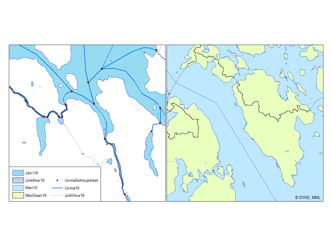
Uomaverkosto
Uomaverkosto pohjautuu Maanmittauslaitoksen maastotietokannan vuosien 2000-2008 aineistoon (1:5 000-1:10 000). Aineiston pohjalta on Sykessä luotu uomia kuvaava uomaverkosto, jonka verkostomainen rakenne on tuotettu lisäämällä viivamaisiin jokiin aluemaisten jokien keskilinjat sekä järvien ylitykset ns. pseudouomilla. Aineistoon on lisätty uomatunnukset.
Uomaverkosto kattaa kaikki vähintään yli 10 km2 yläpuolisen valuma-alueen omaavat uomat. Lisäksi uomaverkosto sisältää myös vesienhoidollisesti merkittäviä alle 10km2 yläpuolisen valuma-alueen omaavia uomia. Uomaverkosto ei sinällään kuvaa uuden vesilain vesistömääritelmän mukaista vesistöä. Uoma vaihtuu toiseksi yksilöllisen uomatunnuksen omaavaksi uomaksi aina uomaverkostoon kuuluvien uomien risteyksessä sekä uoman ja järven yhtymäkohdassa. Uomaverkosto on rakennettu siten, että kaikki siihen kuuluvat osat liittyvät topologiset yhteen ja omaavat oikean virtaussuunnan ja sitä voidaan käyttää erilaisiin verkostoanalyyseihin. Uomien välisiä topologia suhteita kuvaavat tiedot on tallennettu erillisiin tauluihin. Uomille on lisäksi laskettu muita paikantavia ja fysiograafisia tietoja. Uomaverkosto kuuluu Syken avoimiin aineistoihin (CC BY 4.0).
Uomaverkosto-aineistosta on julkaistu INSPIRE-tietotuote.
Käyttötarkoitus:
Uomaverkosto on luotu palvelemaan hyvin laajasti vesivarojen käyttöä ja hoitoa, vesiensuojelua ja vesientutkimusta sekä vesivaroihin liittyvää kansainvälistä ja kansallista raportointia ja tietojärjestelmätyötä.
Lisätietoja:
https://geoportal.ymparisto.fi/meta/julkinen/Dokumentit/ranta10.pdf
https://ckan.ymparisto.fi/dataset/ranta10-rantaviiva-1-10-000
River Network
River network is based on the topographic database of the National Land Survey of Finland in scale of 1:5 000-1:10 000 from years 2000-2008.
The continuous network has been created in Finnish Environment Institute (Syke) by combining rivers to the central lines through polygon rivers and lakes. The dataset includes also unique river codes and lake codes.
The river network includes all river segments with catchment areas larger than 10 km². Other, smaller rivers with smaller catchment areas are also included in case they are considered significant for water management tasks (e.g. WFD). The change from one river segment to another, with unique river code and information, is located at the junction of the river network. The river code also changes at a connection point of a river segment and a lake. The river network has been created such a way that all parts of the network are linked topologically to each other and have a correct flow direction so that the dataset can be used for analyzing the network.
River network is dataset owned by Syke and has same copyright and ownership conditions as other similar datasets owned by Syke. Syke applies Creative Commons By 4.0 International license for open datasets.
River network is developed to serve a wide variety of tasks related to water management, scientific research, water conservation and national and international reporting as well as associated information management.
Simple
- Date (Publication)
- 2012-11-14
- Date (Revision)
- 2026-03-17
- Unique resource identifier
- http://paikkatiedot.fi/so/1002202/hy-n/WatercourseLink
-
SYKE resource classification
-
-
Paikkatietoaineisto
-
- Keywords
-
-
INSPIRE-tietotuote
-
- Keywords
-
-
Järvi
-
joki
-
sisävedet
-
pintavesi
-
- Keywords
-
-
FEO
-
-
High-value dataset categories
-
-
Maan havainnointi ja ympäristö
-
-
EU-legislation
-
-
Arvokkaat tietoaineistot
-
INSPIRE
-
- Use constraints
- Other restrictions
- Other constraints
-
Uomaverkosto on Syken avoin aineisto, jota koskee CC4.0 BY –lisenssi. Creative Commons Nimeä 4.0 Kansainvälinen https://www.syke.fi/fi/ymparistotieto/kayttolupa-ja-vastuut
Uomaverkosto, Lähde: Syke
- Access constraints
- Other restrictions
- Other constraints
- no limitations
- Spatial representation type
- Vector
- Denominator
- 10000
- Metadata language
- Finnish
- Topic category
-
- Inland waters
))
- Distribution format
-
-
ESRI shapefile
(
3.x
)
-
GML
(
3.2.1
)
- Specification
-
D2.8.I.8Data Specification on Hydrography – Technical Guidelines
-
OGC WMS
(
1.3.0
)
-
OGC WFS
(
2.0.0.
)
-
ESRI shapefile
(
3.x
)
- OnLine resource
- Syken Avoin tieto -palvelu
- OnLine resource
- Syken INSPIRE ATOM-syöte
- OnLine resource
- Hydrografia INSPIRE WMS-katselupalvelu
- OnLine resource
- Hydrografia WFS-latauspalvelu
- Hierarchy level
- Dataset
Conformance result
- Date (Publication)
- 2010-12-08
- Explanation
-
Tietotuotemäärittelyt Inspire-direktiivin mukaisten paikkatietotuotteiden osalta.
- Pass
- Yes
- Statement
-
Uomaverkosto pohjautuu Maanmittauslaitoksen maastotietokannan vuosien 2000-2008 aineistoon (1:5 000-1:10 000). Aineiston pohjalta on Sykessä laadittu yhtenäinen topologisesti eheä viivamainen uomaverkosto, joka sisältää aluemaisten jokien ja järvien läpi kulkevat pseudokeskilinjat sekä pienempien jokien viivat, jotka ovat uomaverkoston varrella. Uomaverkostoon on valittu mukaan kaikki yli 10 km2 yläpuolisen valuma-alueen omaavat virtausreitit. Yläpuolisten valuma-alueiden koon mallintamisessa on hyödynnetty MML:n 25m korkeusmallia, jonka virtausreittejä on korostettu Ranta10-aineiston avulla hydrologisen mallinnuksen tarkkuuden parantamiseksi. Lisäksi uomaverkosto sisältää myös vesienhoidollisesti merkittäviä alle 10km2 yläpuolisen valuma-alueen omaavia uomia. Sykessä on korjattu mtk:ssa olevia topologiavirheitä (mm. katkeamat), jotta on saatu luotua topologisesti eheä verkosto. Alueelliset ympäristökeskukset ovat tarkistaneet mallinnetun uomaverkoston virtaussuuntien ja -reittien osalta sekä täydentäneet verkostoa vesienhoidollisesti merkittävillä alle 10km2 yläpuolisen valuma-alueen omaavilla uomilla. Uomille on laskettu yksilöllinen uomatunnus ja muut uomatiedot.
The river network is based on the shoreline data taken from the topographic database of the National Land Survey of Finland (NLS) in the scale of 1:5 000-1:10 000. The source data is from years 2000-2008, after which the geometry data has not been updated. The topological errors of the database have been corrected by Syke to create a river network. The river network dataset has been completed in Syke by adding central lines through polygon rivers and lakes.
The river network includes all river segments with catchment areas larger than 10 km². These were chosen in a hydrological modeling process using 25m DEM of NLS enhanced with Ranta10. Local ELY-centers have verified modeled river network and added river segments considered significant for water management tasks (e.g. WFD).
The dataset also includes spatial and physiographic values calculated for individual rivers.
- File identifier
- {E15CD0B3-3934-4ABC-BF23-A8C622FA6A57} XML
- Metadata language
- Finnish
- Character set
- UTF8
- Hierarchy level
- Dataset
- Date stamp
- 2026-03-17
- Metadata standard name
-
ISO 19115
- Metadata standard version
-
2003/Cor.1:2006
Overviews
Spatial extent
Provided by
