Maritime Spatial Plan 2030 for Finland
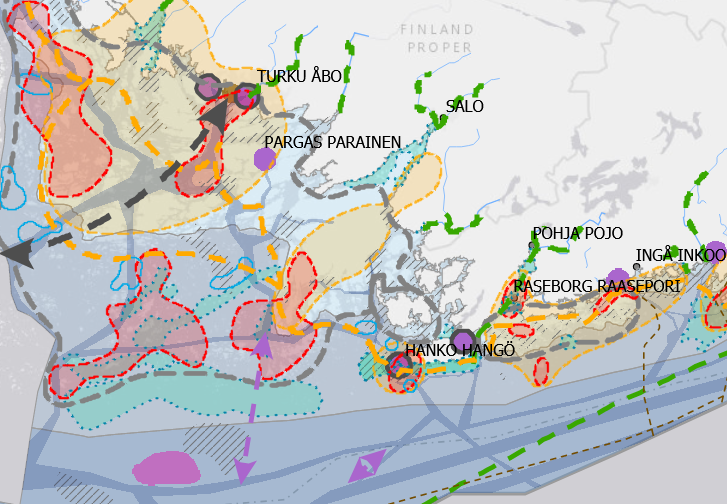
A maritime spatial plan is a strategic development document illustrated by a map. Map markings are used to show the values of marine areas and existing activities and potential future sites for new activities and their alternative placement in all of Finland’s marine areas. The plan covers the territorial waters and the Exclusive Economic Zone. The plan is not legally binding, but an assessment of its indirect and direct impacts and effectiveness forms part of the planning process.
The administrative authorities of coastal regional councils approved the plan, prepared according to the Land Use and Building Act, between November and December 2020. The councils of coastal regions have prepared the maritime spatial plan in three different parts: Gulf of Finland (Helsinki-Uusimaa Regional Council and Regional Council of Kymenlaakso), Archipelago Sea and Southern Bothnian Sea (Regional Council of Southwest Finland and Regional Council of Satakunta), and Northern Bothnian Sea, Quark and Bothnian Bay (Regional Council of Ostrobothnia, Regional Council of Central Ostrobothnia, Council of Oulu Region and Regional Council of Lapland).
The data is suitable for a general-level examination of Finnish marine areas.
More information on maritime spatial plan: https://www.merialuesuunnitelma.fi.
Simple
- Date (Publication)
- 2020-12-15
- Point of contact
-
Organisation name Individual name Electronic mail address Role Varsinais-Suomen liitto
Point of contact Satakuntaliitto
Custodian Pohjanmaan liitto
Custodian Keski-Pohjanmaan liitto
Custodian Pohjois-Pohjanmaan liitto
Custodian Lapin liitto
Custodian Kymenlaakson liitto
Custodian Uudenmaan liitto
Custodian
-
Paikkatietohakemiston asiasanasto
-
-
Not-Inspire
-
Not-Inspire
-
Regional planning and cadastral system
-
-
Alueellinen laajuus
-
-
National
-
- Access constraints
- Other restrictions
- Use constraints
- Other restrictions
- Other constraints
- Attribution 4.0 International (CC BY 4.0)
- Spatial representation type
- Vector
- Denominator
- 750000
- Language
- Finnish
- Language
- Swedish
- Language
- English
- Topic category
-
- Planning cadastre
))
- Unique resource identifier
- EPSG:3067
- Distribution format
-
Name Version OGC:WMS
- OnLine resource
-
Protocol Linkage Name WWW:LINK-1.0-http--link
https://www.merialuesuunnitelma.fi WWW:LINK-1.0-http--link
https://kymenlaakso-geoserver.gispocoding.fi/geoserver/merialuesuunnitelma/wms?request=GetCapabilities&service=WMS WMS-palvelu
WWW:LINK-1.0-http--link
https://kymenlaakso-geoserver.gispocoding.fi/geoserver/merialuesuunnitelma/wfs?request=GetCapabilities&service=WFS WFS-palvelu
- Hierarchy level
- Dataset
Conformance result
- Date (Publication)
- 2010-12-08
- Explanation
-
Aineisto ei ole INSPIRE-tietotuotemäärittelyn mukainen
- Pass
- No
- Statement
-
The administrative authorities of coastal regional councils approved the plan, prepared according to the Land Use and Building Act, between November and December 2020. The councils of coastal regions have prepared the maritime spatial plan in three different parts: Gulf of Finland (Helsinki-Uusimaa Regional Council and Regional Council of Kymenlaakso), Archipelago Sea and Southern Bothnian Sea (Regional Council of Southwest Finland and Regional Council of Satakunta), and Northern Bothnian Sea, Quark and Bothnian Bay (Regional Council of Ostrobothnia, Regional Council of Central Ostrobothnia, Council of Oulu Region and Regional Council of Lapland).
The planning solutions are based on the best available information, such as surveys, studies, modelings, expert assessments, and regional characteristics.
Maritime spatial plans are drawn up in all EU coastal states. In Finland, the plan is not legally binding and does not form part of the land use planning system or land use plan hierarchy. The maritime spatial plan will be updated at least every 10 years.
- File identifier
- 949166e0-156e-4065-9236-5c823be5ea33 XML
- Metadata language
- Finnish
- Hierarchy level
- Dataset
- Hierarchy level
- Dataset
- Hierarchy level name
-
Aineisto
- Date stamp
- 2025-03-19T07:56:04
- Metadata author
-
Organisation name Individual name Electronic mail address Role Varsinais-Suomen liitto
Point of contact
- Other language
-
Language Character encoding Swedish UTF8 English UTF8 Finnish UTF8
Overviews
Spatial extent
Provided by