Paikkatietohakemisto
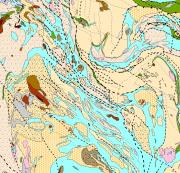
Bedrock of Finland 1:200 000
Bedrock of Finland 1:200 000 is a unified bedrock map dataset covering the whole Finland. It has been compiled by generalising the scale-free bedrock map feature dataset.
The dataset consists of a lithological/stratigraphic geological unit polygon layer and linear layers, in which faults, diverse overprinting lines and dykes are represented. The dataset also includes an origin of the data and a quality estimation of the data polygon layers.
The stratigraphic geological unit polygon layer includes lithological coding, geological time period and hierarchical lithostratigraphical or lithodemic classification as attributes in accordance with the Finnish database for stratigrafic geological units (Finstrati). The line layers have their own hierarchical classification.
The data are at 1:200 000 scale, which indicates that the main part of the scale-free data have been generalised to correspond to a product at a scale of 1:200 000. Those areas where the source data is coarser than 1:200 000 have not been generalised.
Coordinate reference system of the dataset was transformed in March 2013. The transformation from Finnish National Grid Coordinate System (Kartastokoordinaattijärjestelmä, KKJ) Uniform Coordinate Frame to ETRS-TM35FIN projection was done by using the three-dimensional transformation in accordance with the recommendations for the public administration JHS154.
Simple
- Date (Revision)
- 2015-02-17
- Edition
-
1.1
- Presentation form
- digitalGeographicInfo
- Purpose
-
The dataset is suitable for use in analysis of bedrock data, the mineral resource mapping of the bedrock and scientific and applied research. The scale of use of the spatial dataset is 1:200 000.
- Status
- Completed
- Point of contact
-
Organisation name Individual name Electronic mail address Role Geologian tutkimuskeskus
Owner
- Maintenance and update frequency
- Not planned
- Theme
-
-
Bedrock
-
Lithostratigraphy
-
Lithodemic units
-
Geologia
-
- Place
-
-
Finland
-
- Temporal
-
-
Archean
-
Proterozoic
-
Paleozoic
-
-
Geosanasto
-
-
Geologic maps
-
Lithologic maps
-
-
GEMET - INSPIRE themes, version 1.0
-
-
Geology
-
-
Paikkatietohakemiston asiasanasto
-
-
avoindata.fi
-
-
Alueellinen laajuus
-
-
National
-
- Access constraints
- Other restrictions
- Other constraints
- no limitations to public access
- Use constraints
- Other restrictions
- Other constraints
- Attribution 4.0 International (CC BY 4.0)
- Spatial representation type
- Vector
- Denominator
- 200000
- Language
- English
- Character set
- 8859 Part 15
- Topic category
-
- Geoscientific information
))
- Reference system identifier
- EPSG / ETRS89 / ETRS-TM35FIN (EPSG:3067) / 7.4
- Distribution format
-
Name Version ESRI file gdb
10.1
MapInfo TAB
?
- OnLine resource
-
Protocol Linkage Name http://geomaps2.gtk.fi/website1/FinstratiPage.aspx WWW:LINK-1.0-http--link
http://hakku.gtk.fi/fi/locations/search?location_id=2
- Hierarchy level
- Dataset
Conformance result
- Title
-
KOMISSION ASETUS (EU) N:o 1089/2010, annettu 23 päivänä marraskuuta 2010, Euroopan parlamentin ja neuvoston direktiivin 2007/2/EY täytäntöönpanosta paikkatietoaineistojen ja -palvelujen yhteentoimivuuden osalta
- Date (Publication)
- 2010-12-08
- Explanation
-
Ei sääntöjen mukainen.
- Pass
- No
- Statement
-
The scale-free bedrock map feature dataset (BEDROCK.Bedrock_Map_FDS) have been used as source data for the Bedrock of Finland 1:200 000.
The lithological layer, or stratigraphic geological unit polygon layer, of the Bedrock of Finland 1:200 000 has been produced by generalising the scale-free bedrock map feature dataset. Generalisation of the lithological polygons has been done by removing some of the lithological border lines and label points. The stratigraphic unit polygons have been combined such that smaller polygons belonging to the same larger unit have either been removed completely or have been combined in larger stratigraphic entities. For example, members or facies have been partially joined together to form a coherent formation or lithodeme. The aim has been to remove units less than 50 m wide from the data. Polygon attributes have been saved in the label point inside every polygon. The most important attributes are information on the geological time period, stratigraphical unit information (following the Finstrati classification scheme) and lithological classification. Generalised lithological border line and label point layers have been used to build a polygon layer.
The lithological border lines and the fault lines have been classed hierarchically. These also include information on the origin of the lines. It is also possible to record the name of a structure at the fault line layer.
Similarly to the polygon layer, the dyke layer includes information on geological time period, stratigraphical unit classification and lithological classification.
The origin of data layer contains information on the original map (map sheet, scale, author information, year of completion) used as source material for lithological / stratigraphic unit layer. The information is represented as polygons. The layer includes information on the low-altitude aerogeophysical survey year, which by comparison with the date of completion of the map gives an idea of the quality of the source material. The layer contains information on whether the original data have been edited, and if so by whom. The comments field contains additional information on the origin of the source material. The editing of the scale-free bedrock map dataset has mainly been based on low-altitude aerogeophysics, bedrock observations and other maps of the area.
The compilers of the spatial dataset have made a five class quality estimation for the lithological unit polygon layer. The quality estimation is presented as polygons. The quality estimation mainly reflects the quality of the source material. The most important classification criteria have been the scale of the bedrock mapping, observation density, the availability of low-altitude aerogeophysics and lithological diversity in the area. The classes used are:
A = Good data quality: the map is based on new mapping data or is edited from good quality source material with low-altitude aerogeophysics available; 1:200 000 scale bedrock maps of areas where there is little lithological variation (e.g. Koillismaa-Kainuu).
B = Reasonably good data: mapping in progress or incomplete; project maps with reasonable observation density; low- altitude aerogeophysics have been available; old maps of Southern Finland, which are classed as being of good quality because of a good observation density (e.g. Saaristomeri and Ahvenanmaa) or of a simple regional geology (e.g. Southeastern Finland).
C = Mediocre data: areas with old 1:100 000 and 1:400 000 maps, which have undergone limited editing using observation data and low-altitude aerogeophysics; (e.g. regions in the eastern Finland where mapping is in progress).
D = Adequate data quality: areas with old 1:100 000 maps from Southern Finland, in which originally high altitude aerogeophysics has been used and the data has not been edited using low-altitude aerogeophysics: those areas of Southern and central Finland not mapped at a scale of 1:100 000 for which 1:400 000 scale mapping data or material from Outokumpu Oy have been used; areas in northern Finland, which have been digitised for the map database on the basis of low- altitude aerogeophysics and observation data.
E = Adequate data quality- (minus); the areas of the oldest 1:100 000 scale maps in Southern Finland. The maps have been compiled without aerogeophysical data; data have not been edited using low-altitude aerogeophysics; the unmapped areas of Northern Finland which have been digitised for the map database on the basis of low-altitude aerogeophysics.
- Description
-
The lithological layer, or stratigraphic geological unit polygon layer, of the Bedrock of Finland 1:200 000 has been produced by generalising the scale-free bedrock map feature dataset. Generalisation of the lithological polygons has been done by removing some of the lithological border lines and label points. The stratigraphic unit polygons have been combined such that smaller polygons belonging to the same larger unit have either been removed completely or have been combined in larger stratigraphic entities. For example, members or facies have been partially joined together to form a coherent formation or lithodeme. The aim has been to remove units less than 50 m wide from the data. Polygon attributes have been saved in the label point inside every polygon. The most important attributes are information on the geological time period, stratigraphical unit information (following the Finstrati classification scheme) and lithological classification. Generalised lithological border line and label point layers have been used to build a polygon layer.
The lithological border lines and the fault lines have been classed hierarchically. These also include information on the origin of the lines. It is also possible to record the name of a structure at the fault line layer.
Similarly to the polygon layer, the dyke layer includes information on geological time period, stratigraphical unit classification and lithological classification.
The origin of data layer contains information on the original map (map sheet, scale, author information, year of completion) used as source material for lithological / stratigraphic unit layer. The information is represented as polygons. The layer includes information on the low-altitude aerogeophysical survey year, which by comparison with the date of completion of the map gives an idea of the quality of the source material. The layer contains information on whether the original data have been edited, and if so by whom. The comments field contains additional information on the origin of the source material. The editing of the scale-free bedrock map dataset has mainly been based on low-altitude aerogeophysics, bedrock observations and other maps of the area.
The compilers of the spatial dataset have made a five class quality estimation for the lithological unit polygon layer. The quality estimation is presented as polygons. The quality estimation mainly reflects the quality of the source material. The most important classification criteria have been the scale of the bedrock mapping, observation density, the availability of low-altitude aerogeophysics and lithological diversity in the area. The classes used are:
A = Good data quality: the map is based on new mapping data or is edited from good quality source material with low-altitude aerogeophysics available; 1:200 000 scale bedrock maps of areas where there is little lithological variation (e.g. Koillismaa-Kainuu).
B = Reasonably good data: mapping in progress or incomplete; project maps with reasonable observation density; low- altitude aerogeophysics have been available; old maps of Southern Finland, which are classed as being of good quality because of a good observation density (e.g. Saaristomeri and Ahvenanmaa) or of a simple regional geology (e.g. Southeastern Finland).
C = Mediocre data: areas with old 1:100 000 and 1:400 000 maps, which have undergone limited editing using observation data and low-altitude aerogeophysics; (e.g. regions in the eastern Finland where mapping is in progress).
D = Adequate data quality: areas with old 1:100 000 maps from Southern Finland, in which originally high altitude aerogeophysics has been used and the data has not been edited using low-altitude aerogeophysics: those areas of Southern and central Finland not mapped at a scale of 1:100 000 for which 1:400 000 scale mapping data or material from Outokumpu Oy have been used; areas in northern Finland, which have been digitised for the map database on the basis of low- altitude aerogeophysics and observation data.
E = Adequate data quality- (minus); the areas of the oldest 1:100 000 scale maps in Southern Finland. The maps have been compiled without aerogeophysical data; data have not been edited using low-altitude aerogeophysics; the unmapped areas of Northern Finland which have been digitised for the map database on the basis of low-altitude aerogeophysics.
Initially, ArcInfo and ArcView geographical informations systems (GIS) software were used in the processing of the dataset while, later, ArcGIS software was used almost exclusively. Different geophysical dataset has been used as back ground layers in map making process.
Unit attributes are coming from Finnish unit database (Finstrati). The Finstrati database is built up according the international rules and it is maintained by GTK in collaboration with the Precambrian sub-commission of the Stratigraphic Commission of Finland. The Finstrati database contains the latest description of the Finnish bedrock stratigraphy and the references into the publications. The topology of the database is checked.
- Description
-
The scale-free bedrock map feature dataset (BEDROCK.Bedrock_Map_FDS) have been used as source data for the Bedrock of Finland 1:200 000.
- File identifier
- f88b26f6-faea-4911-aaf4-40b1e25b37a0 XML
- Metadata language
- Finnish
- Character set
- 8859 Part 15
- Hierarchy level
- Dataset
- Hierarchy level name
-
Kallioperä 1:200 000
- Date stamp
- 2024-02-06T10:38:28
- Metadata author
-
Organisation name Individual name Electronic mail address Role Geological Survey of Finland
Point of contact
- Other language
-
Language Character encoding English 8859 Part 15 Finnish UTF8