 Paikkatietohakemisto
NLS orthophotos
NLS Orthophotos are an aerial photo dataset covering the whole of Finland. An orthophoto is a combination of several individual aerial photos. The geometry of the orthophotos corresponds to a map.
The aerial photo data set in orthophoto format is available as
- the most recent data set consisting of the most recent aerial photos available. The most recent data is usually 1–3 years old.
- old aerial photos, consisting of data sets that are older than the most recent data set. The oldest aerial photos were taken in the 1930s. New data is added to the data set continuously.
NLS Orthophotos are updated every 3 years (in Northern Lapland 12 years).
Different versions of orthophoto products:
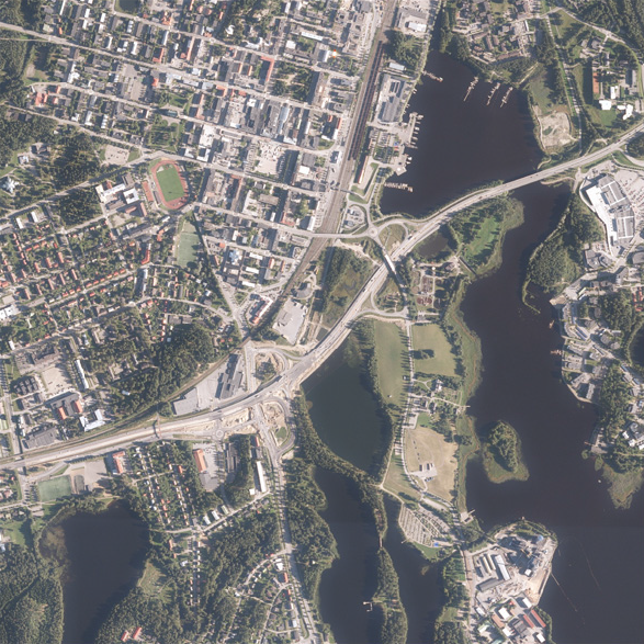
- Ortophoto
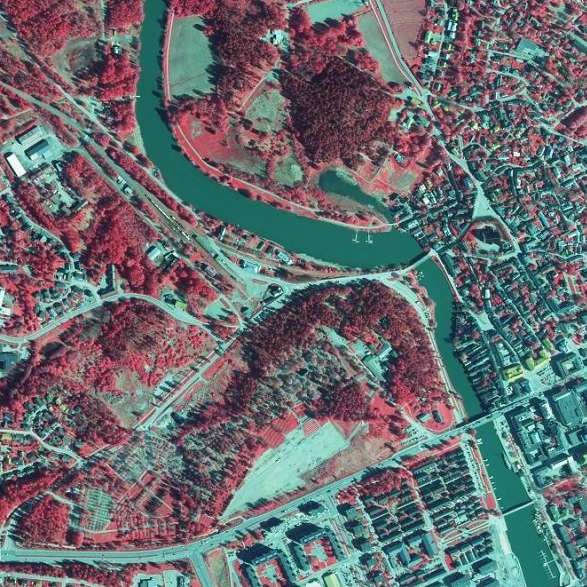
- Ortophoto, false colour
- Ortophoto, forest ortho
- Ortophoto, natural disasters
In addition, there is an index map available presenting the year, when the newest photo was taken in each square.
The product belongs to the open data of the National Land Survey of Finland.
Simple
- Date (Revision)
- 2010-04-01
- Unique resource identifier
- http://paikkatiedot.fi/so/1000244
- Purpose
-
Orthophotos are utilized for mapping and also for planning and monitoring the environment. Colour or black-and-white orthophotos are suitable for planning or as background material for various map presentations. False colour orthopohotos and forest orthos are best suitable for, e.g. forest inventory.
- Maintenance and update frequency
- As needed
- Maintenance note
-
New colour and false colour images are taken every three years, except for North Lapland, which is photographed approximately every 12 years. Aerial photography plans can be seen on the status map https://tilannekartta.maanmittauslaitos.fi/ilmakuva
In addition, product called Ortophoto (forest ortho) is available. The product is similar to Ortophoto (false colour), but colours have been adjusted in order to perceive coniferous and deciduous forests better.
Other product versions are not updated.
The index map of old aerial photos can be seen in Paikkatietoikkuna https://paikkatietoikkuna.fi/historiallisetilmakuvat
The most up-to-date data is available in the interface and viewing services (see Distribution and further information).
The updating status varies by feature depending on the progress of updating.
-
Paikkatietohakemiston asiasanasto
-
-
Terrain and land cover
-
Built environment
-
Waterbodies
-
Environment
-
avoindata.fi
-
Aerial photos
-
Orthophotos
-
-
GEMET - INSPIRE themes, version 1.0
-
-
Orthoimagery
-
- Access constraints
- Other restrictions
- Other constraints
- no limitations to public access
- Use constraints
- Other restrictions
- Other constraints
- Attribution 4.0 International (CC BY 4.0)
- Other constraints
-
Mention the name of the Licensor (the National Land Survey of Finland), the name of the dataset(s) and the time when the National Land Survey has delivered the dataset(s) (e.g.: contains data from the National Land Survey of Finland Topographic Database 06/2014).
- Spatial representation type
- Grid
- Distance
- 0.5 m
- Metadata language
- Finnish
- Topic category
-
- Imagery base maps earth cover
- Location
- Inland waters
- Environment
))
- Supplemental Information
-
The metadata of the orthophotos is provided by request.
- Reference system identifier
- EPSG / ETRS89 / TM35FIN(E,N) (EPSG:3067) / 8.6
- Distribution format
-
-
Tiff (tfw)
(
1.0
)
-
JPEG2000
(
1.0
)
-
Tiff (tfw)
(
1.0
)
- Transfer size
- 4000000
- OnLine resource
- MapSite Download geospatial data section ( WWW:LINK-1.0-http--link )
- OnLine resource
-
Karttakuvapalvelu (WMS) palvelukuvaus
(
WWW:LINK-1.0-http--link
)
Karttakuvapalvelu (WMS)
- OnLine resource
-
Karttakuvapalvelu (WMTS)
(
WWW:LINK-1.0-http--link
)
Karttakuvapalvelu (WMTS)
- OnLine resource
- Ortokuvien ja korkeusmallien kyselypalvelu (WCS) rajapintaosoite ( http://www.opengis.net/def/serviceType/ogc/wcs )
- OnLine resource
-
Ortokuvien ja korkeusmallien kyselypalvelu (WCS) palvelukuvaus
(
WWW:LINK-1.0-http--link
)
Ortokuvien ja korkeusmallien kyselypalvelu (WCS)
- OnLine resource
- Paikkatiedon tiedostopalvelu (OGC API Processes) rajapintaosoite ( http://www.opengis.net/def/docs/18-062r2 )
- OnLine resource
- Karttakuvapalvelu (WMS) sopimusrajapinta ( http://www.opengis.net/def/serviceType/ogc/wms )
- OnLine resource
- Karttakuvapalvelu (WMTS) avoin rajapintaosoite ( http://www.opengis.net/def/serviceType/ogc/wmts )
- OnLine resource
- Paikkatiedon tiedostopalvelu (OGC API Processes) ( WWW:LINK-1.0-http--link )
- OnLine resource
- Hakemistokäyttöliittymä ( WWW:LINK-1.0-http--link )
- Hierarchy level
- Dataset
Conformance result
- Date (Publication)
- 2010-12-08
- Pass
- Yes
- Statement
-
NLS Orthophotos is the only set of aerial photographs that covers the whole of Finland.
Starting from 2009, orthophotos are also available in colour and false colour format. The coordinate reference system used in the photo shoots until 2007 was KKJ, i.e. the national grid coordinate system (zones of the coordinate reference system). As of 2008, the coordinate reference system used in aerial photos has been ETRS89/TM35FIN.
The accuracy of an orthophoto depends on the sensor used in aerial photography, the photographing altitude and the elevation model used in producing the orthophoto. The elevation model has the biggest influence on the geometrical accuracy of the photo. The positional accuracy of an orthophoto is 0.5–2 metres.
The product can be printed out on scale ranging from 1:1 000.
Content Information
- Included with dataset
- No
- Date (Revision)
- 2020-09-18
- Other citation details
-
Film, black-and-white
Pixel size 0.5 metres.
Normal size 10,000 x 10,000 pixels (general map-sheet division, KKJ).
Normal size 12,000 x 12,000 pixels (TM35 map-sheet division, ETRS-TM35FIN) consists of a maximum of 256 different greyscale values (8 bit).
Film, false colour
Pixel size 0.5 m.
Normal size 10,000 x 10,000 pixels (general map-sheet division, KKJ).
Normal size 12,000 x 12,000 pixels (TM35 map-sheet division, ETRS-TM35FIN) consists of three colour channels (near-IR, red, green).
Each colour channel contains a maximum of 256 different shade values (8 bit).
Digital, colour
Pixel size 0.5 m.
Normal size 12,000 x 12,000 pixels (TM35 map-sheet division, ETRS-TM35FIN) consists of three colour channels (red, green, blue).
Each colour channel contains a maximum of 256 different shade values (8 bit).
Digital, false colour
Pixel size 0.5 m.
Normal size 12,000 x 12,000 pixels (TM35 map-sheet division, ETRS-TM35FIN) consists of three colour channels (near-IR, red, green).
Each colour channel contains a maximum of 256 different shade values (8 bit).
- File identifier
- 8bc5dfd6-752a-40bc-9620-d67e43ab07ae XML
- Metadata language
- Finnish
- Character set
- 8859 Part 10
- Hierarchy level
- Dataset
- Hierarchy level name
-
Aineisto
- Date stamp
- 2025-03-04T14:53:13
- Metadata standard name
-
ISO 19115:2003/19139
- Metadata standard version
-
1.0
Overviews
Spatial extent
Provided by
