Paikkatietohakemisto
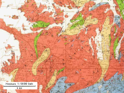
Geological map of Finland, pre-quaternary 1:100 000
The 1:100 000 scale bedrock map data of the Geological Survey of Finland (GTK) include material produced during 1948-2007 for the needs of the mapping of mineral resources, for the sustainable exploitation of aggregate resources and for scientific research. These data include lithological information as polygons, bedrock observation points and drilling sites as well as essential tectonic observations, and information on lithological primary structures, ore minerals and metamorphic index minerals. Some 1:100 000 map sheets give both stratigraphical information as well as lithological data. An explanatory text accompanies most map sheets.
Simple
- Date (Publication)
- 2014-10-23T00:00:00
- Edition
-
1.0
- Presentation form
- Digital map
- Purpose
-
The 1:100 000 scale bedrock mapping data area suitable for guiding the mapping of mineral raw materials, for maintaining rock aggregate resources, for scientific and applied research, for landuse planning and for environmental management of bedrock conservation programmes. The scale of use of the map data is 1:100 000.
- Status
- Completed
- Point of contact
-
Organisation name Individual name Electronic mail address Role Geological Survey of Finland
Owner
- Maintenance and update frequency
- Not planned
- Discipline
-
-
Areal geology
-
Geologic maps
-
Lithologic maps
-
- Place
-
-
Finland
-
-
Geosanasto
-
-
Archaean
-
Proterozoic
-
Paleoproterozoic
-
- Theme
-
-
Bedrock
-
-
GEMET - INSPIRE themes, version 1.0
-
-
Geology
-
-
Paikkatietohakemiston asiasanasto
-
-
Not-Inspire
-
avoindata.fi
-
- Access constraints
- Other restrictions
- Other constraints
- no limitations to public access
- Use constraints
- Other restrictions
- Other constraints
- Attribution 4.0 International (CC BY 4.0)
- Spatial representation type
- Vector
- Denominator
- 100000
- Language
- Finnish
- Character set
- 8859 Part 15
- Topic category
-
- Geoscientific information
))
- Reference system identifier
- EPSG / ETRS89 / ETRS-TM35FIN (EPSG:3067) / 7.4
- Distribution format
-
Name Version ESRI shapefile
9.3
tiff
1.1.2011
- OnLine resource
-
Protocol Linkage Name WWW:DOWNLOAD-1.0-http--download
http://hakku.gtk.fi/fi/locations/search?location_id=11
- Hierarchy level
- Series
Conformance result
- Title
-
Data Specification on Geology - Technical Guidelines
- Date (Publication)
- 2010-12-08
- Explanation
-
Ei sääntöjen mukainen.
- Pass
- No
Conformance result
- Date (Publication)
- 2010-12-08
- Explanation
-
Aineisto ei ole INSPIRE-tietotuotemäärittelyn mukainen
- Pass
- No
- Statement
-
More recent maps available from the National Land Survey of Finland (NLS), such as 1:100 000 scale economic maps, 1:20 000 scale base or topographic maps as well as black and white or false colour aerial photographs and aerial photography maps, have been used to locate and position bedrock observation points. Since 1998, observation points have also been positioned using GPS equipment; a practice which became standard in 2000. Bedrock observations were recorded in observation diaries or on observation forms and entered in the databases of the Geological Survey of Finland (GTK). The high-altitude aerogeophysical maps of the GTK as well as processed low-altitude data that were available at the time were used in the delineation of rock units.
- Description
-
In the field, bedrock observations were recorded in an observation diary and located and positioned using the 1:100 000 Economic Map of Finland, 1:20 000 base or topographic maps, aerial photographs at different scales or 1:20 000 air photo maps.
Beginning in 1998, observation points were also positioned using a GPS device with an accuracy of >10 m (<10 m from 2000). The observations were entered in the bedrock observation and drill core databases of the Geological Survey of Finland (GTK). Besides high-altitude aerogeophysical maps, available low-altitude aerogeophysical data were used to delineate rock units, the latter giving a higher accuracy in interpretation.
From 1998, observation points were located using a GPS device with a position accuracy of >10 m (<10 m from 2000). The observations were entered in the bedrock observation and drill core databases of the Geological Survey of Finland (GTK). From the beginning of the 1980s, the data has been digitised using FINGIS software and from 1997 using the ArcView program.
- Description
-
More recent maps available from the National Land Survey of Finland (NLS), such as 1:100 000 scale economic maps, 1:20 000 scale base or topographic maps as well as black and white or false colour aerial photographs and aerial photography maps, have been used to locate and position bedrock observation points. Since 1998, observation points have also been positioned using GPS equipment; a practice which became standard in 2000. Bedrock observations were recorded in observation diaries or on observation forms and entered in the databases of the Geological Survey of Finland (GTK). The high-altitude aerogeophysical maps of the GTK as well as processed low-altitude data that were available at the time were used in the delineation of rock units.
- File identifier
- 8838726a-18c7-4ff7-9128-86fb50b6ade4 XML
- Metadata language
- Finnish
- Character set
- 8859 Part 15
- Hierarchy level
- Series
- Hierarchy level name
-
Kallioperä 1:100 000
- Date stamp
- 2024-02-15T14:59:53
- Metadata author
-
Organisation name Individual name Electronic mail address Role Geological Survey of Finland
Point of contact
- Other language
-
Language Character encoding English 8859 Part 15 Finnish UTF8