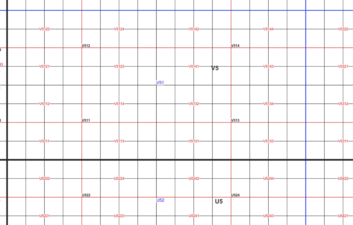
Map sheet division
The map sheet division is a system created for printing maps, which covers map sheet codes, map scales and map sheet sizes. Today, map sheet division is also used for other purposes. It is also possible to download other NLS datasets in addition to maps in accordance with map sheet division. The map sheet division TM35, which is based on the projected coordinate reference system ETRS-TM35FIN is in use today. Before 2007, a map sheet division that was based on the KKS coordinate reference system was used.
The TM35 map sheet division consists of 7 different grid sizes, the smallest scale is 1:200,000 and the largest is 1:5000. An explanation of how the grids are further split into more detailed grids and the principles of map sheet numbering is on the National Land Survey website (in Finnish) https://www.maanmittauslaitos.fi/kartat-ja-paikkatieto/kartat/osta-kartta/nain-loydat-oikean-karttalehden. The attribute data of the grids include map sheet number, the area of a square on the grid, perimeter and the coordinates of the centre of the square.
The map sheet division is available as a file in vector format and through our contract-based WMTS service in raster format. In addition, you can view it in the geoportal Paikkatietoikkuna.
The product is a part of the open data of the National Land Survey.
Simple
- Date (Publication)
- 2007-05-30
- Unique resource identifier
- http://paikkatiedot.fi/so/1000014
- Purpose
-
Map sheet division shows how printed maps or maps in a file format are divided for each scale.
-
Paikkatietohakemiston asiasanasto
-
-
avoindata.fi
-
Not-Inspire
-
-
GEMET - INSPIRE themes, version 1.0
-
-
Geographical grid systems
-
- Access constraints
- Other restrictions
- Other constraints
- no limitations to public access
- Use constraints
- Other restrictions
- Other constraints
- Attribution 4.0 International (CC BY 4.0)
- Other constraints
-
Mention the name of the Licensor (the National Land Survey of Finland), the name of the dataset(s) and the time when the National Land Survey has delivered the dataset(s) (e.g.: contains data from the National Land Survey of Finland Topographic Database 06/2014).
- Spatial representation type
- Grid
- Spatial representation type
- Vector
- Denominator
- 5000
- Denominator
- 10000
- Denominator
- 25000
- Denominator
- 50000
- Denominator
- 100000
- Denominator
- 200000
- Denominator
- 1000
- Metadata language
- Finnish
- Topic category
-
- Location
))
- Reference system identifier
- EPSG / ETRS89 / TM35FIN(E,N) (EPSG:3067) / 8.6
- Number of dimensions
- 2
- Dimension name
- Row
- Dimension size
- 2400
- Resolution
- 10 m
- Dimension name
- Column
- Dimension size
- 1200
- Resolution
- 10 m
- Transformation parameter availability
- No
- Distribution format
-
-
PNG
(
)
-
ESRI Shapefile
(
)
-
PDF
(
)
-
GeoPackage
(
)
-
PNG
(
)
- OnLine resource
- MapSite Download geospatial data section ( WWW:LINK-1.0-http--link )
- OnLine resource
- Map image service (WMS ja WMTS) (in Finnish) ( WWW:LINK-1.0-http--link )
- OnLine resource
- Geodata portalen Paikkatietoikkuna ( WWW:LINK-1.0-http--link )
- OnLine resource
- Näin löydät oikean karttalehden (in Finnish) ( WWW:LINK-1.0-http--link )
- OnLine resource
- Aineiston erillistoimitus (maksullinen, koskee KKJ-karttalehtijakoa) ( WWW:LINK-1.0-http--link )
- OnLine resource
- Paikkatiedon tiedostopalvelu (OGC API Processes)
- Hierarchy level
- Dataset
Conformance result
- Date (Publication)
- 2010-12-08
- Explanation
-
Aineisto on INSPIRE-tietotuotemäärittelyn mukainen
- Pass
- No
- Statement
-
Until 2007, printed maps were published in a map sheet division based on the coordinate reference system KKJ. This map sheet division is shown in a pdf-file: https://www.maanmittauslaitos.fi/sites/maanmittauslaitos.fi/files/attachments/2023/11/KKJ_karttalehtijako.pdf
Since 2007, the map sheet division TM35 has been in use. The largest grid level conforms to a map in scale 1:200,000. The most precise level is 1:5000. The product also includes the map sheet divisions of printed maps, such as the basic map 1 25,000 and topographic map 1:50,000.
The GeoPackage file (BETA, https://asiointi.maanmittauslaitos.fi/karttapaikka/tiedostopalvelu?lang=en) also contains the map sheet division in scale 1:1000 (1 km x 1 km) used for laser scanning data 5 p.
- Date
- 2022-01-01
- Other citation details
-
Map sheet division TM35, Map sheet division KKJ
- File identifier
- 7581db43-4ed7-4a69-9a02-c662d0941cb9 XML
- Metadata language
- Finnish
- Hierarchy level
- Dataset
- Hierarchy level name
-
Aineisto
- Date stamp
- 2023-11-16T15:44:23
Overviews

Spatial extent
))
Provided by

 Paikkatietohakemisto