Paikkatietohakemisto
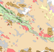
Superficial deposits 1:20 000 / 1:50 000
The Superficial deposits 1:20 000 / 1:50 000 data include material produced during the period 1972-2007 for land use planning, for the mapping and inventory of the natural resources as well as for environmental management and for scientific research. The main mapping scale has been 1:10 000. The data contains a sediment as a basal deposit at a depth of one metre. The minimum size of the basal deposit polygon is two hectares, with islands, mire and field enclosures, as well as geologically significant sites as an exception. The 0.4-0.9 m thick layers are described as overlying the basal deposit and, in geologically or economically significant cases, such layers could be even thicker. The minimum polygon size of the overlying deposit is usually four hectares. Thin covering layers under 0.4 m in thickness, which are difficult to delimit but effect an area of at least four hectares, are displayed as point data. Besides the deposits Quaternary geological formations formed in different ways, such as eskers and hummocky moraines, are described in the data. Other mapping sites such as small rock exposures, dunes and raised beaches are shown as point or line data.
Coordinate reference system of the Superficial deposits 1:20 000 / 1:50 000 was transformed in March 2013. The transformation from Finnish National Grid Coordinate System (Kartastokoordinaattijärjestelmä, KKJ) Uniform Coordinate Frame to ETRS-TM35FIN projection was done by using the three-dimensional transformation in accordance with the recommendations for the public administration JHS154.
Simple
- Date (Publication)
- 2015-01-01
- Purpose
-
The Superficial deposits of Finland 1:200 000 (sediment polygons) is suitable for use at a general scale (medium scale) in land-use planning, in the mapping and inventory of the natural resources of land areas, in environmental management, in agriculture and forestry and in education as well as in scientific and applied research. The scale of use of the map data set is 1:100 000-1:250 000.
- Credit
-
Maa- ja elintarviketalouden tutkimuskeskus
- Credit
-
Maanmittauslaitos
- Credit
-
Metsäntutkimuslaitos
- Credit
-
Oulun yliopisto
- Credit
-
Puolustusvoimat
- Credit
-
Turun yliopisto
- Status
- Completed
- Point of contact
-
Organisation name Individual name Electronic mail address Role Geological Survey of Finland
Owner
-
Geosanasto
-
-
Soils
-
Glacial features
-
Sediments
-
Shore features
-
Eolian features
-
Raised beaches
-
Erosion features
-
Ground water
-
Samples
-
Drilling
-
- Place
-
-
Finland
-
- Temporal
-
-
Quaternary
-
- Discipline
-
-
Geologic maps
-
Surficial geology maps
-
Geologic sites
-
-
GEMET - INSPIRE themes, version 1.0
-
-
Geology
-
-
Alueellinen laajuus
-
-
National
-
- Access constraints
- Other restrictions
- Other constraints
- no limitations to public access
- Use constraints
- Other restrictions
- Other constraints
- Attribution 4.0 International (CC BY 4.0)
- Spatial representation type
- Vector
- Denominator
- 20000
- Denominator
- 50000
- Language
- Finnish
- Topic category
-
- Geoscientific information
))
- Reference system identifier
- http://www.opengis.net/def/crs/EPSG/0/3067
- Topology level
- Geometry only
- Distribution format
-
Name Version ESRI file gdb
10.0
- OnLine resource
-
Protocol Linkage Name WWW:LINK-1.0-http--link
http://hakku.gtk.fi/fi/locations/search?location_id=1 WWW:LINK-1.0-http--link
http://gtkdata.gtk.fi/Maankamara/index.html Maankamara
- Hierarchy level
- Dataset
Conformance result
- Title
-
KOMISSION ASETUS (EU) N:o 1089/2010, annettu 23 päivänä marraskuuta 2010, Euroopan parlamentin ja neuvoston direktiivin 2007/2/EY täytäntöönpanosta paikkatietoaineistojen ja -palvelujen yhteentoimivuuden osalta
- Date (Publication)
- 2010-12-08
- Explanation
-
Tietotuotemäärittelyä ei ole vielä julkaistu.
- Pass
- No
- Statement
-
The following have been used as background data for the Superficial deposits mapping: available base maps and black and white or false colour aerial photographs as stereoscopic pairs at a scale of 1:10 000 (these were those that were more recent at the time of mapping produced by the National Land Survey (NLS)); the Quaternary, bedrock, rock aggregate and groundwater research data of the Geological Survey of Finland (GTK); and other studies dealing with the geology of the area. The positioning (locating) of deposit boundaries and of other exposures was done mainly using aerial photographs and base maps. The use of GPS positioning began in 1998.
The Superficial deposits 1:20 000/1:50 000 mapping process consisting of preliminary work, fieldwork and data completion work. Preparatory work consists of the collection of the maps, aerial photographs and previous research necessary for background data as well as making preliminary field observations and a pre-interpretation on base maps and 1:10 000 aerial photographs. After 2003 preliminary work consists of the collection and preparation of the necessary digital map data and aerial photographs and previous research. The data were transferred to a field computer equipped with a GPS device and GIS software. In the field, preliminary observations were entered directly into the field computer, after which an pre-interpretation was made at a scale of 1:10 000.
A probing rod and a spade were used to aid sediment identification during fieldwork. Boundaries between superficial deposits and other superficial observations were marked on base map transparencies overlain on 1:10 000 stereoscopic aerial photographs and on observation log sheets. Deposit polygons were drawn on the basis of field observations and stereoscopic aerial photo interpretation. The positioning of observations was achieved mainly using a map and an aerial photograph; accuracy varied depending on the terrain. From 1998, GPS devices were introduced for use in positioning. Where necessary, field mapping was supplemented by soil (deposit) samples, and with drillings and soundings. After 2003 the boundaries between deposit and other superficial deposit observations were entered into the field computer.
The data completion work consisted of checking of the deposit polygons and other superficial deposit data and final drafting, the selection of drilling and other information for the final map and the entering of the data into the databases of the Geological Survey of Finland (GTK).
Coordinate reference system of the Superficial deposits 1:20 000/1:50 000 was transformed in March 2013. The transformation from Finnish National Grid Coordinate System (Kartastokoordinaattijärjestelmä, KKJ) Uniform Coordinate Frame to ETRS-TM35FIN projection was done by using the three-dimensional transformation in accordance with the recommendations for the public administration JHS154.
In fieldwork, a probing rod and a spade were used to aid sediment identification.
From 1998, observation points were positioned using GPS equipment with an accuracy of >10 m (<10 m from 2000). The observations were entered into the databases of the Geological Survey of Finland (GTK). From 2003, field observations began to be entered directly into a field data storage device.
The processing and editing of the data was carried out using GIS software.
- Description
-
The Superficial deposits 1:20 000/1:50 000 mapping process consisting of preliminary work, fieldwork and data completion work. Preparatory work consists of the collection of the maps, aerial photographs and previous research necessary for background data as well as making preliminary field observations and a pre-interpretation on base maps and 1:10 000 aerial photographs. After 2003 preliminary work consists of the collection and preparation of the necessary digital map data and aerial photographs and previous research. The data were transferred to a field computer equipped with a GPS device and GIS software. In the field, preliminary observations were entered directly into the field computer, after which an pre-interpretation was made at a scale of 1:10 000.
A probing rod and a spade were used to aid sediment identification during fieldwork. Boundaries between superficial deposits and other superficial observations were marked on base map transparencies overlain on 1:10 000 stereoscopic aerial photographs and on observation log sheets. Deposit polygons were drawn on the basis of field observations and stereoscopic aerial photo interpretation. The positioning of observations was achieved mainly using a map and an aerial photograph; accuracy varied depending on the terrain. From 1998, GPS devices were introduced for use in positioning. Where necessary, field mapping was supplemented by soil (deposit) samples, and with drillings and soundings. After 2003 the boundaries between deposit and other superficial deposit observations were entered into the field computer.
The data completion work consisted of checking of the deposit polygons and other superficial deposit data and final drafting, the selection of drilling and other information for the final map and the entering of the data into the databases of the Geological Survey of Finland (GTK).
Coordinate reference system of the Superficial deposits 1:20 000/1:50 000 was transformed in March 2013. The transformation from Finnish National Grid Coordinate System (Kartastokoordinaattijärjestelmä, KKJ) Uniform Coordinate Frame to ETRS-TM35FIN projection was done by using the three-dimensional transformation in accordance with the recommendations for the public administration JHS154.
- File identifier
- 0f3f054f-ad70-4cf1-a1d1-93589261bd04 XML
- Metadata language
- Finnish
- Hierarchy level
- Dataset
- Hierarchy level name
-
Aineisto
- Date stamp
- 2023-10-11T15:47:43
- Metadata author
-
Organisation name Individual name Electronic mail address Role Geologian tutkimuskeskus
Point of contact
- Other language
-
Language Character encoding English 8859 Part 15 Finnish UTF8