 Paikkatietohakemisto
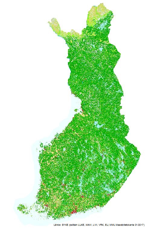
Corine maanpeite 2018
CORINE Land Cover 2018 kuvaa koko Suomen maankäyttöä ja maanpeitettä vuonna 2018. Sykessä EU:n Copernicus Land -hankkeessa tuotettiin Suomen alueelta maanpeiteaineistot sekä laadittiin maanpeitteen muutoksia välillä 2012-2018 kuvaavat aineistot. Aineistot luotiin kahdella tarkkuustasolla: toinen EU-vaatimusten mukaisesti ja toinen kansalliseen käyttöön. Aineisto koostuu rasterimuotoisesta paikkatietokannasta (erotuskyky 20 * 20 m) ja vektorimuotoisesta paikkatietokannasta, jossa pienin maastossa erottuva alue on vähintään 25 ha ja kapeimmillaan 100 metriä.
Kansallisen muutosaineiston 2012-2018 pienin kuvio on 0,5 ha ja eurooppalaisen 5 ha.
Aineisto on tuotettu Sykessä olemassa oleviin paikkatietoaineistoihin sekä satelliittikuvatulkintaan perustuen. Vektoriaineisto tuotettiin yleistämällä rasteriaineistoa EEA:n CORINE-sääntöjen mukiseksi.
Vektoriaineistoissa maankäyttöä/maanpeitettä kuvataan kolmitasoisella hierarkisella luokittelulla. Viisi pääluokkaa (rakennetut alueet; maatalousalueet; metsät sekä avoimet kankaat ja kalliomaat; kosteikot ja avoimet suot sekä vesialueet) jaetaan toisella tasolla yhteensä 15 alaluokkaan.. Kolmannella luokittelutasolla luokat jaetaan edelleen yhteensä 44 alaluokkaan. Rasteriaineistossa on joidenkin luokkien kohdalla vielä neljännen tason kansallisia luokkia.
Aineisto kuuluu SYKEn avoimiin aineistoihin (CC BY 4.0).
Aineistosta on julkaistu INSPIRE-tietotuote.
Käyttötarkoitus:
Vektoriaineisto, jossa minimikuviokoko on 25 ha/muutos 5 ha, on tuotettu Euroopan ympäristövirastolle. Tarkempi 20 m resoluutiolla oleva rasteriaineisto ja 1 ha muutosaineisto on tarkoitettu kansalliseen käyttöön kuvaamaan maanpeitettä/maankäyttöä. Aineistoja voidaan käyttää paikkatietoanalyysien lisäksi myös taustakarttoina.
Lisätietoja:
https://geoportal.ymparisto.fi/meta/julkinen/dokumentit/CorineMaanpeite2018.pdf
https://geoportal.ymparisto.fi/meta/julkinen/dokumentit/CorineMaanpeite2018Luokat.xls
https://geoportal.ymparisto.fi/meta/julkinen/dokumentit/CorineMaanpeite2018Luokkakuvaus.pdf
CORINE Land Cover 2018 dataset provides information on Finnish land cover and land use on 2018, and its changes from 2012 to 2018. The data was produced as a part of EU Copernicus Land project.
The dataset includes several spatial layers:
• CLC raster (resolution of 20x20 m)
• CLC vector (minimum mapping unit 25 hectares and minimum width 100 m).
• Change vector (minimum mapping unit 5 hectares)
• Change raster (minimum mapping unit 0,5 hectares)
The dataset has been produced in Finnish Environment Institute (Syke), based on automated interpretation of satellite images and data integration with existing digital map data. The vector dataset was produced from raster data by generalization according to the CORINE 2018 project class definitions.
The nomenclature of the vector data has 3 hierarchy levels. The first level classes are: artificial surfaces, agricultural areas, forests and seminatural areas, wetlands and water. The second level has 15 classes and the third level 44 sub-classes. The raster dataset has an additional fourth, national class in some of the sub-classes.
Syke applies Creative Commons By 4.0 International license for open datasets.
Data was produced with funding by the European Union. Copyright Copernicus Programme.
Syke has undertaken to distribute the data on behalf of EEA under Specific Contract No 3436/R0-Copernicus/EEA.56936 implementing Framework service contract No EEA/IDM/R0/16/009/Finland. Syke accepts no responsibility or liability whatsoever with regard to the content and use of these data.
The vector land cover dataset (25 ha) and the change dataset (5 ha) were produced for the European Environment Agency as a part of EU Copernicus Land project for harmonized land cover maps and statistics in Europe. The more specific raster dataset (20 m x 20 m) and the change (0,5 ha) were produced for national use to provide information on Finnish land cover and land use. The datasets can be used in analyses and as background maps.
The source material is generally from years 2016-2017.
Simple
- Date (Publication)
- 2018-11-27
- Unique resource identifier
- http://paikkatiedot.fi/so/1002032/lc/LandCoverUnit/
-
SYKE resource classification
-
-
Paikkatietoaineisto
-
- Keywords
-
-
INSPIRE-tietotuote
-
- Keywords
-
-
Maanpeite
-
maankäyttö
-
- Keywords
-
-
FEO
-
-
High-value dataset categories
-
-
Maan havainnointi ja ympäristö
-
-
EU legislation
-
-
Arvokkaat tietoaineistot
-
INSPIRE
-
- Use constraints
- Other restrictions
- Other constraints
-
Creative Commons Nimeä 4.0 Kansainvälinen http://www.syke.fi/fi-FI/Avoin_tieto/Kayttolupa_ja_vastuut
Lupatekstit:
Lähde: Syke (osittain LUKE, MAVI, LIVI, DVV, EU, MML Maastotietokanta 01/2017)
Vektoriaineisto Lähde: Syke, EEA, EU/Copernicus
- Access constraints
- Other restrictions
- Other constraints
- no limitations
- Spatial representation type
- Vector
- Denominator
- 100000
- Metadata language
- Finnish
- Topic category
-
- Environment
))
- Begin date
- 2018-01-01
- Distribution format
-
-
ESRI shapefile
(
3.x
)
-
GeoTiff
(
1
)
-
GML
(
3.2.1
)
- Specification
-
D2.8.II.2 Data Specification on Land Cover – Technical Guidelines
-
OGC WMS
(
1.3.0
)
-
OGC WFS
(
2.0.0.
)
-
OGC WCS
(
2.0.1.
)
-
ESRI shapefile
(
3.x
)
- OnLine resource
- Syken Avoin tieto -palvelu
- OnLine resource
- Syken Avoin tieto -palvelu
- OnLine resource
- Syken INSPIRE ATOM-syöte
- OnLine resource
- Maanpeite INSPIRE WMS-katselupalvelu
- OnLine resource
- Maanpeite INSPIRE WCS-katselupalvelu
- OnLine resource
- Maanpeite WFS-katselupalvelu
- Hierarchy level
- Dataset
Conformance result
- Date (Publication)
- 2010-12-08
- Explanation
-
Tietotuotemäärittelyt Inspire-direktiivin mukaisten paikkatietotuotteiden osalta.
- Pass
- Yes
- Statement
-
CLC2018-luokkien muodostamiseen on käytetty useita eri paikkatietoaineistoja, tärkeimpinä Maanmittauslaitoksen Maastotietokanta, Liikenneviraston Digiroad, Digi- ja väestötietoviraston Väestötietojärjestelmä (Rakennus- ja huoneistorekisteri), Maaseutuviraston peltolohkot vallitsevan kasvin mukaan, EU/Copernicus-ohjelman Imperviousness2015-aineisto sekä CLC2012. Paikkatietoaineistoista saatu maankäyttö ja maaperätieto yhdistettiin Image 2017 -satelliittikuvilta (Sentinel 2) tulkittuihin maanpeitetietoihin. Tulkinnassa hyödynnettiin lisäksi mm.Luonnonvarakeskuksen VMI2015-aineistoa, Metsäkeskuksen laserkeilausaineistoa, digitaalista korkeusmallia ja maaperää kuvaavia teemoja Maastotietokannasta. Lisäksi muutamia luokkia tulkittiin satelliittikuvilta manuaalisesti digitoimalla, kuten golfkentät. Lopputuloksena saatiin rasterimuotoinen paikkatietoaineisto 20 metrin pikselikoolla.
Several spatial datasets have been used to compile Finnish CLC2018 classes, most notably The Topographic Database of Finland, Digiroad (digital road database of Finland), Building and dwelling register, Finnish Land Parcel Information System, CLC2012. Land cover and land use information gathered from these sources was integrated with land cover data interpreted from satellite images. The satellite image mosaic used in producing CLC2018 (IMAGE2017) was compiled from ESA Sentinel 2 a+b MSI instruments, with 10*10 m resolution. In the satellite image interpretation process National Forest Inventory data (from Finnish Forest Research Institute), Biotope data (from Metsähallitus), Digital Elevation Model and Soil Information from Topographic Database were also used. In addition, some classes were manually interpreted from the satellite imagery. As a result of combining all these datasets was a spatial database in raster format with 20 m pixel size.
- File identifier
- {0B4B2FAC-ADF1-43A1-A829-70F02BF0C0E5} XML
- Metadata language
- Finnish
- Character set
- UTF8
- Hierarchy level
- Dataset
- Date stamp
- 2024-05-20
- Metadata standard name
-
ISO 19115
- Metadata standard version
-
2003/Cor.1:2006
Overviews
Spatial extent
Provided by
